

The Chapel of St-Jean d'Orgerolles

No reviews yet
Have you flown here? Share your experience with other pilots.
+ Write the first reviewDescription
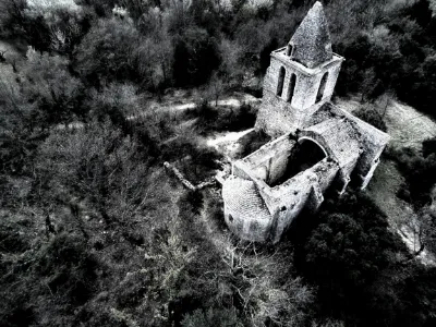
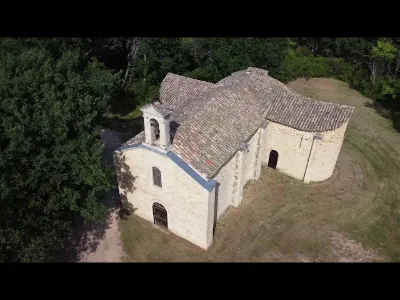
Located 10 km from Uzès, between La Bastide-d'Engras and Pougnadoresse, the chapel of Saint-Jean d'Orgerolles served as a place of worship for these two villages and offers a magnificent view over the Tave plain, the Rhône, Mont Ventoux, the Alps and the Alpilles!
The Romanesque part of the chapel dates from the end of the 11th and the beginning of the 12th century.
In the 16th century, a 21-meter-high bell tower in late Romanesque style was added to the building, most likely for defensive purposes during the Wars of Religion. Inscriptions deciphered on the northwest corner buttress, "VV le roy, VV Bastide 1588", support this hypothesis.
The construction of the bell tower came with that of two side chapels, which required cutting two large openings in the south wall to access them. This architectural intervention weakened the structure and led to the collapse of the vaults of two bays in the 20th century.
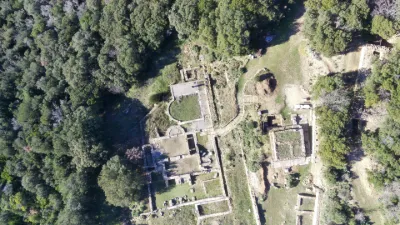
Next to the chapel lies the forgotten cemetery of Saint Jean d'Orgerolles, where you can still see dozens of beautiful steles, fallen into oblivion. The cemetery was still in use until 1910…
Map and restricted areas
Open in the main mapNearby aerodromes
Open aerodromes within 25 km of the spot, heliports included, with their distance and direction from the spot. Near an aerodrome, drone flying is prohibited or height-limited: check the UAS zones map.
| Aerodrome | Type | Distance | Elevation | Difference |
|---|---|---|---|---|
| Uzès Airfield | Aerodrome | 7.5 km W | 270 m | spot 66 m lower |
| Aérodrome d'Avignon-Pujaut | Aerodrome | 24 km SE | 45 m | spot 159 m higher |
Aviation weather (METAR and TAF)
LFMO – Orange-Caritat (BA 115) Air Base VFR
METAR
METAR LFMO 210700Z AUTO 33004KT CAVOK 04/04 Q1020 NOSIG
- Wind
- 330°, 7 km/h
- Visibility
- 10 km or more
- Clouds
- –
- Temperature
- 4 °C, dew point 4 °C
- QNH
- 1020 hPa
- Flight category
- VFR: ceiling > 3,000 ft and visibility > 5 mi
TAF
TAF LFMO 210200Z 2103/2203 32003KT CAVOK TX16/2115Z TN05/2105Z PROB30 TEMPO 2122/2203 4000 -RA BECMG 2201/2203 13015G25KT
| Period (local time) | Change | Wind | Visibility | Weather | Clouds |
|---|---|---|---|---|---|
| 21/11 04:00 → 22/11 02:00 | Initial conditions | 320°, 6 km/h | 10 km or more | No significant cloud | |
| 21/11 23:00 → 22/11 04:00 | Temporarily, probability 30% | 4.0 km | Rain light | ||
| 22/11 02:00 → 22/11 04:00 | Becoming | 130°, 28 km/h, gusts 46 km/h | 10 km or more | No significant cloud |
Weather and Kp index
| Day | Weather | Temp. min. / max. | Wind | Rain | Max Kp |
|---|---|---|---|---|---|
| Sat 21 Nov | Fair | 7° / 15° | 12 km/h E | 1.4 mm | 2 |
| Sun 22 Nov | Fair | 10° / 15° | 24 km/h W | 5.1 mm | 2 |
| Mon 23 Nov | Fair | 7° / 13° | 17 km/h N | – | 4 |
| Tue 24 Nov | Cloudy | 4° / 8° | 19 km/h N | 3.2 mm | 2 |
| Wed 25 Nov | Heavy rain | 6° / 8° | 18 km/h SE | 42 mm | – |
| Thu 26 Nov | Clear sky | 4° / 11° | 5 km/h NE | – | – |
| Fri 27 Nov | Clear sky | 2° / 10° | 7 km/h N | – | – |
Hour by hour: Saturday 21 November
| Time | Weather | Temp. | Wind | Rain | Clouds | Kp |
|---|---|---|---|---|---|---|
| 08:00 | Partly cloudy | 7° | 10 km/h N | – | 100 % | 2 |
| 09:00 | Partly cloudy | 8° | 6 km/h N | – | 99 % | 2 |
| 10:00 | Partly cloudy | 11° | 6 km/h N | – | 87 % | 2 |
| 11:00 | Partly cloudy | 13° | 5 km/h N | – | 59 % | 2 |
| 12:00 | Fair | 14° | 6 km/h N | – | 28 % | 2 |
| 13:00 | Fair | 15° | 4 km/h N | – | 31 % | 1 |
| 14:00 | Partly cloudy | 15° | 3 km/h NE | – | 52 % | 1 |
| 15:00 | Partly cloudy | 15° | 2 km/h SE | – | 48 % | 1 |
| 16:00 | Partly cloudy | 14° | 3 km/h SE | – | 77 % | 2 |
| 17:00 | Partly cloudy | 12° | 4 km/h SE | – | 86 % | 2 |
| 18:00 | Partly cloudy | 10° | 5 km/h SE | – | 94 % | 2 |
| 19:00 | Partly cloudy | 10° | 6 km/h SE | – | 98 % | 2 |
| 20:00 | Cloudy | 9° | 6 km/h SE | – | 100 % | 2 |
| 21:00 | Cloudy | 10° | 7 km/h SE | – | 100 % | 2 |
| 22:00 | Rain | 10° | 9 km/h E | 0.5 mm | 100 % | 2 |
Hour by hour: Sunday 22 November
| Time | Weather | Temp. | Wind | Rain | Clouds | Kp |
|---|---|---|---|---|---|---|
| 06:00 | Rain | 14° | 18 km/h S | 0.5 mm | 100 % | 2 |
| 07:00 | Light rain | 14° | 16 km/h S | 0.2 mm | 100 % | 2 |
| 08:00 | Fog | 14° | 14 km/h SW | – | 100 % | 2 |
| 09:00 | Partly cloudy | 12° | 22 km/h W | – | 84 % | 2 |
| 10:00 | Cloudy | 13° | 19 km/h W | – | 100 % | 2 |
| 11:00 | Partly cloudy | 14° | 23 km/h W | – | 41 % | 2 |
| 12:00 | Fair | 15° | 24 km/h W | – | 27 % | 2 |
| 13:00 | Fair | 15° | 23 km/h W | – | 34 % | 2 |
| 14:00 | Partly cloudy | 15° | 23 km/h W | – | 46 % | 2 |
| 15:00 | Fair | 14° | 21 km/h W | – | 35 % | 2 |
| 16:00 | Fair | 14° | 24 km/h W | – | 24 % | 2 |
| 17:00 | Fair | 12° | 21 km/h W | – | 30 % | 2 |
| 18:00 | Partly cloudy | 11° | 19 km/h W | – | 56 % | 2 |
| 19:00 | Partly cloudy | 12° | 20 km/h W | – | 48 % | 2 |
| 20:00 | Partly cloudy | 11° | 21 km/h NW | – | 54 % | 2 |
| 21:00 | Partly cloudy | 11° | 21 km/h NW | – | 49 % | 2 |
| 22:00 | Fair | 11° | 20 km/h NW | – | 35 % | 2 |
Sunrise and sunset
| Day | Dawn | Sunrise | Golden hour | Sunset | Dusk | Day length |
|---|---|---|---|---|---|---|
| Sat 21 Nov | 07:13 | 07:45 | 07:45–08:30 · 16:26–17:11 | 17:11 | 17:42 | 9 h 25 |
| Sun 22 Nov | 07:15 | 07:46 | 07:46–08:31 · 16:25–17:10 | 17:10 | 17:42 | 9 h 23 |
| Mon 23 Nov | 07:16 | 07:47 | 07:47–08:33 · 16:24–17:09 | 17:09 | 17:41 | 9 h 21 |
| Tue 24 Nov | 07:17 | 07:49 | 07:49–08:34 · 16:23–17:09 | 17:09 | 17:41 | 9 h 19 |
| Wed 25 Nov | 07:18 | 07:50 | 07:50–08:35 · 16:23–17:08 | 17:08 | 17:40 | 9 h 18 |
| Thu 26 Nov | 07:19 | 07:51 | 07:51–08:37 · 16:22–17:08 | 17:08 | 17:39 | 9 h 16 |
| Fri 27 Nov | 07:20 | 07:52 | 07:52–08:38 · 16:21–17:07 | 17:07 | 17:39 | 9 h 14 |


Reviews
Log in to review this spot. Log in · Create a free account
No reviews yet. Share yours!