

Briançon, the Pont d'Asfeld
No reviews yet
Have you flown here? Share your experience with other pilots.
+ Write the first reviewDescription
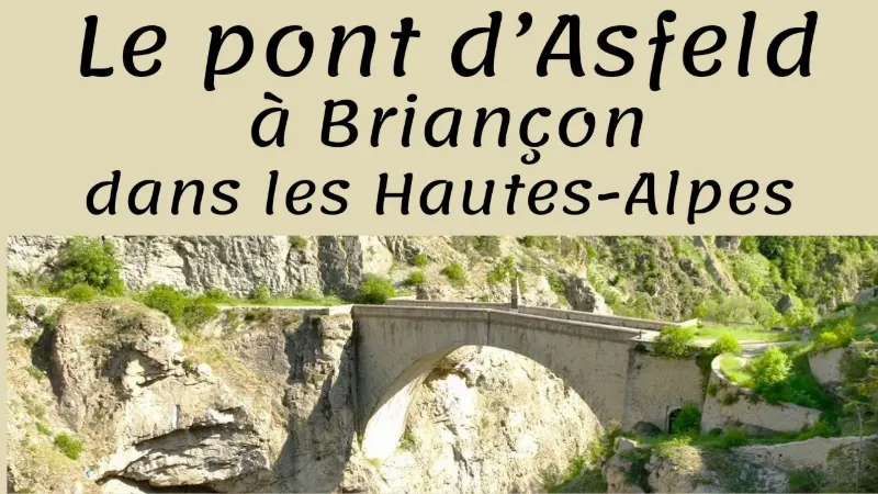
A true work of engineering, combining technical achievement and aesthetics, this bridge was built to link the upper town with the forts on the left bank of the Durance. An airy, dizzying structure, the Pont d'Asfeld has spanned the Durance since the 18th century, connecting the upper town of Briançon with the forts that defend it.
As part of the works program begun in 1720 under the orders of the Marquis d'Asfeld, who gave it his name, this stone bridge plays a central role in the defense of Briançon, an essential stronghold in the Alps and a true defensive lock in the Durance valley. This bold structure, which spans a gorge 55 meters deep in a single arch, links the upper town with the forts built on the Têtes plateau, on the left bank of the Durance.
In the middle of the bridge stands an ironwork cross crowning a stone pyramid. A bronze plaque, a facsimile of the original, displays the date 1731, which corresponds to the Marquis d'Asfeld's elevation to the rank of Marshal of France. Completely renovated in 1987, the Pont d'Asfeld is among the structures listed as UNESCO World Heritage under the Fortifications of Vauban.
Map and restricted areas
Open in the main mapNearby aerodromes
Open aerodromes within 25 km of the spot, heliports included, with their distance and direction from the spot. Near an aerodrome, drone flying is prohibited or height-limited: check the UAS zones map.
| Aerodrome | Type | Distance | Elevation | Difference |
|---|---|---|---|---|
| Centre Hospitalier Heliport | Heliport | 1.5 km NW | 1,333 m | spot 5 m higher |
| Mont-Dauphin - St-Crépin Airfield | Aerodrome | 22 km S | 903 m | spot 435 m higher |
Aviation weather (METAR and TAF)
No METAR station within 50 km.
Weather and Kp index
Sunrise and sunset
| Day | Dawn | Sunrise | Golden hour | Sunset | Dusk | Day length |
|---|---|---|---|---|---|---|
| Sat 21 Nov | 07:07 | 07:39 | 07:39–08:24 · 16:14–17:00 | 17:00 | 17:32 | 9 h 21 |
| Sun 22 Nov | 07:08 | 07:40 | 07:40–08:26 · 16:13–16:59 | 16:59 | 17:31 | 9 h 19 |
| Mon 23 Nov | 07:09 | 07:41 | 07:41–08:27 · 16:12–16:58 | 16:58 | 17:31 | 9 h 17 |
| Tue 24 Nov | 07:10 | 07:43 | 07:43–08:29 · 16:11–16:58 | 16:58 | 17:30 | 9 h 15 |
| Wed 25 Nov | 07:11 | 07:44 | 07:44–08:30 · 16:11–16:57 | 16:57 | 17:29 | 9 h 13 |
| Thu 26 Nov | 07:13 | 07:45 | 07:45–08:31 · 16:10–16:56 | 16:56 | 17:29 | 9 h 11 |
| Fri 27 Nov | 07:14 | 07:46 | 07:46–08:33 · 16:09–16:56 | 16:56 | 17:28 | 9 h 09 |




Reviews
Log in to review this spot. Log in · Create a free account
No reviews yet. Share yours!