

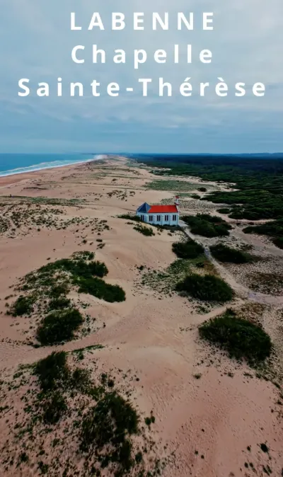
The Sainte Thérèse chapel in Labenne

No reviews yet
Have you flown here? Share your experience with other pilots.
+ Write the first reviewDescription
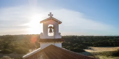
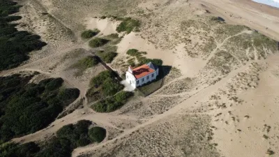
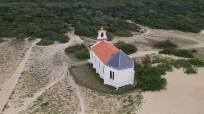
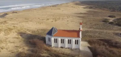
The chapel was built in 1932 on the dunes at Labenne Océan. Classical in architectural style, it consists of a sanctuary and a single nave. The interior of the chapel is decorated with a Way of the Cross painted by a fine arts student, Suzanne Labatut. The Germans, who occupied the chapel during the Second World War, fled with the bell. It was replaced after the occupation. Over the years, the chapel suffered from weather damage and vandalism, and became very run down. Because of its heritage value and its location on the dune, the Conservatoire du Littoral carried out its restoration in the autumn of 2018. The bell was restored and put back in its small bell tower for the chapel's inauguration in June 2019. The chapel is not open to the public, except for special events, but it can be admired from the outside.
Map and restricted areas
Open in the main mapNearby aerodromes
Open aerodromes within 25 km of the spot, heliports included, with their distance and direction from the spot. Near an aerodrome, drone flying is prohibited or height-limited: check the UAS zones map.
| Aerodrome | Type | Distance | Elevation | Difference |
|---|---|---|---|---|
| Centre Hospitalier De La Côte Basque Heliport | Heliport | 14 km S | 23 m | spot 15 m lower |
| Biarritz-Anglet-Bayonne Airport | Airport | 17 km S | 75 m | spot 67 m lower |
Aviation weather (METAR and TAF)
LFBZ – Biarritz-Anglet-Bayonne Airport VFR
METAR
METAR LFBZ 171330Z AUTO 01007KT 340V050 9999 FEW006 BKN058 OVC074 16/15 Q1003 NOSIG
- Wind
- 010°, 13 km/h
- Visibility
- 10 km or more
- Clouds
- Few (1-2/8) at 600 ft (180 m) ; Broken (5-7/8) at 5,800 ft (1770 m) ; Overcast (8/8) at 7,400 ft (2260 m)
- Temperature
- 16 °C, dew point 15 °C
- QNH
- 1003 hPa
- Flight category
- VFR: ceiling > 3,000 ft and visibility > 5 mi
TAF
TAF LFBZ 171100Z 1712/1812 25008KT 9999 BKN045 TEMPO 1712/1713 4000 SHRA BKN010 BKN030TCU PROB30 TEMPO 1716/1718 4000 -SHRA BKN040TCU TEMPO 1722/1803 22015G25KT TEMPO 1803/1808 29015G30KT 2500 SHRA BKN008 BKN020TCU TEMPO 1808/1810 4000 -SHRA BKN050TCU
| Period (local time) | Change | Wind | Visibility | Weather | Clouds |
|---|---|---|---|---|---|
| 17/11 13:00 → 18/11 13:00 | Initial conditions | 250°, 15 km/h | 10 km or more | Broken (5-7/8) at 4,500 ft (1370 m) | |
| 17/11 13:00 → 17/11 14:00 | Temporarily | 4.0 km | Showers of rain | Broken (5-7/8) at 1,000 ft (300 m) ; Broken (5-7/8) at 3,000 ft (910 m) (towering cumulus) | |
| 17/11 17:00 → 17/11 19:00 | Temporarily, probability 30% | 4.0 km | Showers of rain light | Broken (5-7/8) at 4,000 ft (1220 m) (towering cumulus) | |
| 17/11 23:00 → 18/11 04:00 | Temporarily | 220°, 28 km/h, gusts 46 km/h | |||
| 18/11 04:00 → 18/11 09:00 | Temporarily | 290°, 28 km/h, gusts 56 km/h | 2.5 km | Showers of rain | Broken (5-7/8) at 800 ft (240 m) ; Broken (5-7/8) at 2,000 ft (610 m) (towering cumulus) |
| 18/11 09:00 → 18/11 11:00 | Temporarily | 4.0 km | Showers of rain light | Broken (5-7/8) at 5,000 ft (1520 m) (towering cumulus) |
Weather and Kp index
Sunrise and sunset
| Day | Dawn | Sunrise | Golden hour | Sunset | Dusk | Day length |
|---|---|---|---|---|---|---|
| Tue 17 Nov | 07:31 | 08:02 | 08:02–08:46 · 16:56–17:39 | 17:39 | 18:10 | 9 h 36 |
| Wed 18 Nov | 07:33 | 08:04 | 08:04–08:47 · 16:55–17:38 | 17:38 | 18:09 | 9 h 34 |
| Thu 19 Nov | 07:34 | 08:05 | 08:05–08:49 · 16:54–17:38 | 17:38 | 18:09 | 9 h 32 |
| Fri 20 Nov | 07:35 | 08:06 | 08:06–08:50 · 16:53–17:37 | 17:37 | 18:08 | 9 h 30 |
| Sat 21 Nov | 07:36 | 08:07 | 08:07–08:52 · 16:52–17:36 | 17:36 | 18:07 | 9 h 28 |
| Sun 22 Nov | 07:37 | 08:09 | 08:09–08:53 · 16:51–17:35 | 17:35 | 18:07 | 9 h 26 |
| Mon 23 Nov | 07:38 | 08:10 | 08:10–08:54 · 16:50–17:35 | 17:35 | 18:06 | 9 h 24 |

Reviews
Log in to review this spot. Log in · Create a free account
No reviews yet. Share yours!