

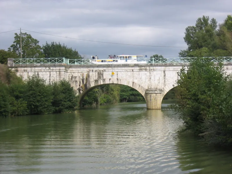
Canal Bridge over the Baïse (also in the commune of Vianne)
No reviews yet
Have you flown here? Share your experience with other pilots.
+ Write the first reviewHistory
Pont-canal construit par l'inspecteur des ponts et chaussées Thomas de Baudre et l'ingénieur Job. Il s'agit du second pont-canal du canal latéral à celui du Midi. L'ouvrage en pierre de taille comporte trois arches couvertes en plein cintre. Aux extrémités du pont, le raccordement avec les bajoyers est assuré par une culée formant un massif de maçonnerie. La jonction entre ce massif et le pont est assurée par un bec traité en quart de cylindre couvert d'un chaperon plat. Les piles du pont sont protégées en amont comme en aval par deux becs semblables mais semi-cylindriques. Sur la corniche repose un garde-corps en fonte d'esprit néo-classique. Sur le pont où le lit du canal est théoriquement profond, deux banquettes revêtues de galets servaient au passage des piétons et au halage. Par un jeu de galets noirs et clairs, la banquette orientale est ornée d'une grecque sur toute sa longueur. Sur le territoire de Vianne, au nord-ouest, se trouve le dispositif d'approche du pont-canal, avec écluse et bassin d'attente à l'entrée du pont.
Map and restricted areas
Open in the main mapRestricted zones
| Zone | Category | Limits | Conditions |
|---|---|---|---|
| Zena Perigord Low | ZRT | FL 165 / FL 195 | SUP AIP 062/26 · Du jeudi 23 avril 2026 au jeudi 25 mars 2027 |
Nearby aerodromes
Open aerodromes within 25 km of the spot, heliports included, with their distance and direction from the spot. Near an aerodrome, drone flying is prohibited or height-limited: check the UAS zones map.
| Aerodrome | Type | Distance | Elevation |
|---|---|---|---|
| Montpezat d'Agenais | Aerodrome | 19 km NE | 37 m |
| Agen-La Garenne Airport | Airport | 22 km E | 62 m |
Aviation weather (METAR and TAF)
LFBA – Agen-La Garenne Airport IFR
METAR
METAR LFBA 171400Z AUTO 26004KT 230V290 2900 +RA BR SCT006/// BKN012/// OVC019/// ///TCU 14/14 Q1003 TEMPO 3000 RA BKN014 BKN035 FEW060CB
- Wind
- 260°, 7 km/h
- Visibility
- 2.9 km
- Weather
- Rain heavy ; mist
- Clouds
- Scattered (3-4/8) at 600 ft (180 m) ; Broken (5-7/8) at 1,200 ft (370 m) ; Overcast (8/8) at 1,900 ft (580 m)
- Temperature
- 14 °C, dew point 14 °C
- QNH
- 1003 hPa
- Flight category
- IFR: ceiling 500–1,000 ft or visibility 1–3 mi
TAF
TAF AMD LFBA 171415Z 1714/1721 25010KT CAVOK TEMPO 1714/1717 2000 RA SCT005 BKN014 BKN035 FEW060CB TEMPO 1719/1721 3000 RA BKN040TCU
| Period (local time) | Change | Wind | Visibility | Weather | Clouds |
|---|---|---|---|---|---|
| 17/11 15:00 → 17/11 22:00 | Initial conditions | 250°, 19 km/h | 10 km or more | No significant weather | No significant cloud |
| 17/11 15:00 → 17/11 18:00 | Temporarily | 2.0 km | Rain | Scattered (3-4/8) at 500 ft (150 m) ; Broken (5-7/8) at 1,400 ft (430 m) ; Broken (5-7/8) at 3,500 ft (1070 m) | |
| 17/11 20:00 → 17/11 22:00 | Temporarily | 3.0 km | Rain | Broken (5-7/8) at 4,000 ft (1220 m) (towering cumulus) |
Weather and Kp index
| Day | Weather | Temp. min. / max. | Wind | Rain | Max Kp |
|---|---|---|---|---|---|
| Tue 17 Nov | Heavy rain | 13° / 14° | 16 km/h SW | 12 mm | 5 |
| Wed 18 Nov | Showers | 12° / 18° | 24 km/h W | 5.4 mm | 5 |
| Thu 19 Nov | Showers | 10° / 14° | 30 km/h W | 10 mm | 3 |
| Fri 20 Nov | Fair | 10° / 14° | 25 km/h W | 6.3 mm | 3 |
| Sat 21 Nov | Cloudy | 8° / 15° | 14 km/h SE | 2.5 mm | – |
| Sun 22 Nov | Showers | 11° / 15° | 26 km/h W | 3.3 mm | – |
| Mon 23 Nov | Cloudy | 8° / 15° | 13 km/h SW | 0.1 mm | – |
Hour by hour: Tuesday 17 November
| Time | Weather | Temp. | Wind | Rain | Clouds | Kp |
|---|---|---|---|---|---|---|
| 15:00 | Heavy rain | 14° | 13 km/h W | 1.9 mm | 100 % | 4 |
| 16:00 | Heavy rain | 14° | 9 km/h SW | 2.5 mm | 100 % | 4 |
| 17:00 | Heavy rain | 13° | 10 km/h SW | 2.1 mm | 100 % | 4 |
| 18:00 | Heavy rain | 13° | 10 km/h SW | 2.2 mm | 100 % | 4 |
| 19:00 | Heavy rain | 13° | 14 km/h SW | 2.4 mm | 100 % | 5 |
| 20:00 | Light rain | 14° | 15 km/h SW | 0.1 mm | 100 % | 5 |
| 21:00 | Cloudy | 14° | 16 km/h SW | – | 100 % | 5 |
| 22:00 | Rain | 14° | 15 km/h SW | 0.6 mm | 99 % | 5 |
Hour by hour: Wednesday 18 November
| Time | Weather | Temp. | Wind | Rain | Clouds | Kp |
|---|---|---|---|---|---|---|
| 06:00 | Partly cloudy | 14° | 21 km/h W | – | 46 % | 4 |
| 07:00 | Fair | 14° | 21 km/h W | – | 13 % | 4 |
| 08:00 | Clear sky | 13° | 19 km/h W | – | 5 % | 4 |
| 09:00 | Clear sky | 13° | 18 km/h SW | – | 2 % | 4 |
| 10:00 | Clear sky | 15° | 19 km/h SW | – | 12 % | 4 |
| 11:00 | Showers | 16° | 22 km/h W | 0.3 mm | 54 % | 4 |
| 12:00 | Showers | 16° | 23 km/h W | 0.2 mm | 43 % | 4 |
| 13:00 | Showers | 17° | 24 km/h W | 0.2 mm | 32 % | 3 |
| 14:00 | Clear sky | 18° | 22 km/h W | – | 11 % | 3 |
| 15:00 | Fair | 18° | 21 km/h W | – | 23 % | 3 |
| 16:00 | Clear sky | 18° | 15 km/h W | – | 4 % | 3 |
| 17:00 | Partly cloudy | 15° | 6 km/h SW | – | 88 % | 3 |
| 18:00 | Cloudy | 13° | 9 km/h S | – | 99 % | 3 |
| 19:00 | Cloudy | 13° | 11 km/h SE | – | 100 % | 2 |
| 20:00 | Cloudy | 14° | 15 km/h SE | – | 100 % | 2 |
| 21:00 | Rain | 14° | 20 km/h SE | 0.5 mm | 100 % | 2 |
| 22:00 | Heavy rain | 13° | 22 km/h SE | 2.4 mm | 100 % | 2 |
Sunrise and sunset
| Day | Dawn | Sunrise | Golden hour | Sunset | Dusk | Day length |
|---|---|---|---|---|---|---|
| Tue 17 Nov | 07:26 | 07:57 | 07:57–08:41 · 16:46–17:30 | 17:30 | 18:02 | 9 h 33 |
| Wed 18 Nov | 07:27 | 07:58 | 07:58–08:43 · 16:45–17:29 | 17:29 | 18:01 | 9 h 31 |
| Thu 19 Nov | 07:28 | 07:59 | 07:59–08:44 · 16:44–17:29 | 17:29 | 18:00 | 9 h 29 |
| Fri 20 Nov | 07:29 | 08:01 | 08:01–08:46 · 16:43–17:28 | 17:28 | 17:59 | 9 h 27 |
| Sat 21 Nov | 07:30 | 08:02 | 08:02–08:47 · 16:42–17:27 | 17:27 | 17:59 | 9 h 24 |
| Sun 22 Nov | 07:32 | 08:03 | 08:03–08:48 · 16:41–17:26 | 17:26 | 17:58 | 9 h 22 |
| Mon 23 Nov | 07:33 | 08:05 | 08:05–08:50 · 16:40–17:26 | 17:26 | 17:57 | 9 h 21 |

Reviews (0)
Log in to review this spot. Log in · Create a free account
No reviews yet. Share yours!