

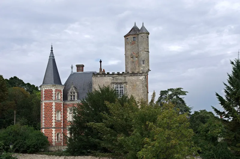
Beaumont Castle
No reviews yet
Have you flown here? Share your experience with other pilots.
+ Write the first reviewHistory
Beaumont fut d'abord une châtellenie relevant de Maillé et dont le premier seigneur est cité en 1108. D'un château du 13e siècle subsiste un donjon carré découronné de son chemin de ronde et de son étage supérieur en 1780. Chaque angle possédait une tourelle en encorbellement, dont il ne subsiste que celle du nord. Au 16e siècle, les murs Est et sud furent percés de fenêtres accostées de pilastres. En même temps fut élevée une tour octogonale en briques. Le logis d'habitation se développe au nord du donjon. La façade a été refaite au 18e siècle. De 1874 à 1880, il a été prolongé par une construction de style Louis XII.
Map and restricted areas
Open in the main mapRestricted zones
Nearby aerodromes
Open aerodromes within 25 km of the spot, heliports included, with their distance and direction from the spot. Near an aerodrome, drone flying is prohibited or height-limited: check the UAS zones map.
| Aerodrome | Type | Distance | Elevation |
|---|---|---|---|
| Tours-Val-de-Loire Airport | Airport | 16 km S | 109 m |
Aviation weather (METAR and TAF)
No METAR station within 50 km.
Weather and Kp index
Sunrise and sunset
| Day | Dawn | Sunrise | Golden hour | Sunset | Dusk | Day length |
|---|---|---|---|---|---|---|
| Tue 17 Nov | 07:32 | 08:05 | 08:05–08:53 · 16:31–17:19 | 17:19 | 17:53 | 9 h 13 |
| Wed 18 Nov | 07:33 | 08:07 | 08:07–08:55 · 16:30–17:18 | 17:18 | 17:52 | 9 h 11 |
| Thu 19 Nov | 07:34 | 08:08 | 08:08–08:57 · 16:29–17:17 | 17:17 | 17:51 | 9 h 08 |
| Fri 20 Nov | 07:36 | 08:10 | 08:10–08:58 · 16:27–17:16 | 17:16 | 17:50 | 9 h 06 |
| Sat 21 Nov | 07:37 | 08:11 | 08:11–09:00 · 16:26–17:15 | 17:15 | 17:49 | 9 h 04 |
| Sun 22 Nov | 07:38 | 08:12 | 08:12–09:02 · 16:25–17:14 | 17:14 | 17:49 | 9 h 01 |
| Mon 23 Nov | 07:40 | 08:14 | 08:14–09:03 · 16:24–17:14 | 17:14 | 17:48 | 8 h 59 |
Reviews (0)
Log in to review this spot. Log in · Create a free account
No reviews yet. Share yours!