

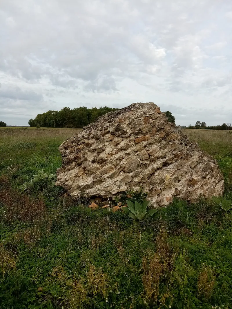
Remains of the Gallo-Roman Fanum
No reviews yet
Have you flown here? Share your experience with other pilots.
+ Write the first reviewHistory
Vestiges d'un fanum gallo-romain constitué par un cône de maçonnerie formée d'assises régulières de moellons, unis par un mortier très dur de sable de falunière. Il est possible qu'un parement appareillait primitivement ce blocage, mais toute trace en a disparu. Soit à la suite de fouilles, soit par effondrement des substructions, le bloc s'est incliné du côté méridional. Au début du 20e siècle, un second bloc était visible à proximité, représentant la partie supérieure de l'édifice, mais il a été morcelé et a disparu.
Map and restricted areas
Open in the main mapRestricted zones
Nearby aerodromes
Open aerodromes within 25 km of the spot, heliports included, with their distance and direction from the spot. Near an aerodrome, drone flying is prohibited or height-limited: check the UAS zones map.
| Aerodrome | Type | Distance | Elevation |
|---|---|---|---|
| Tours Le Louroux Airport | Aerodrome | 12 km N | 126 m |
| Centre Hospitalier Heliport | Heliport | 25 km S | 84 m |
| Tours Sorigny Airport | Aerodrome | 25 km N | 91 m |
Aviation weather (METAR and TAF)
No METAR station within 50 km.
Weather and Kp index
Sunrise and sunset
| Day | Dawn | Sunrise | Golden hour | Sunset | Dusk | Day length |
|---|---|---|---|---|---|---|
| Tue 17 Nov | 07:30 | 08:04 | 08:04–08:51 · 16:33–17:21 | 17:21 | 17:54 | 9 h 17 |
| Wed 18 Nov | 07:32 | 08:05 | 08:05–08:53 · 16:32–17:20 | 17:20 | 17:53 | 9 h 14 |
| Thu 19 Nov | 07:33 | 08:07 | 08:07–08:54 · 16:31–17:19 | 17:19 | 17:52 | 9 h 12 |
| Fri 20 Nov | 07:34 | 08:08 | 08:08–08:56 · 16:30–17:18 | 17:18 | 17:52 | 9 h 09 |
| Sat 21 Nov | 07:36 | 08:09 | 08:09–08:58 · 16:29–17:17 | 17:17 | 17:51 | 9 h 07 |
| Sun 22 Nov | 07:37 | 08:11 | 08:11–08:59 · 16:28–17:16 | 17:16 | 17:50 | 9 h 05 |
| Mon 23 Nov | 07:38 | 08:12 | 08:12–09:01 · 16:27–17:15 | 17:15 | 17:49 | 9 h 03 |
Reviews (0)
Log in to review this spot. Log in · Create a free account
No reviews yet. Share yours!