

Courcelles-le-Roy Castle
No reviews yet
Have you flown here? Share your experience with other pilots.
+ Write the first reviewHistory
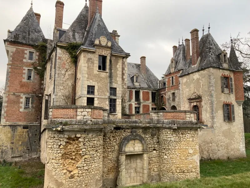
Le château s'ordonne autour d'un quadrilatère. Trois corps de bâtiment entourent la cour intérieure. La façade sud-ouest présente un bâtiment du 17e siècle. Au centre se détache un pavillon qui semble dater de la même époque mais peut être un pastiche du 19e siècle. Aux extrémités de cette façade ont été ajoutées, au 19e siècle, des ailes terminées par des tours, celles du sud-est ayant été démolies au 20e siècle et remplacées par un pavillon. La façade nord-est présente une succession de trois pavillons reliés entre eux. Au centre, le "châtelet" a été modifié ou construit au 19e siècle. Au nord se trouve la chapelle élevée à la fin du 18e siècle. A l'ouest de ces bâtiments se trouvent les écuries, le colombier à lanternon et les communs avec la grange.
Map and restricted areas
Open in the main mapRestricted zones
Nearby aerodromes
Open aerodromes within 25 km of the spot, heliports included, with their distance and direction from the spot. Near an aerodrome, drone flying is prohibited or height-limited: check the UAS zones map.
| Aerodrome | Type | Distance | Elevation |
|---|---|---|---|
| Base ULM de Beaulieu-sur-Loire | Aerodrome | 4.9 km E | 135 m |
| Briare Chatillon Airport | Aerodrome | 7.0 km N | 164 m |
| Base ULM de Sury en Vaux | Aerodrome | 19 km S | 305 m |
| Cosne Sur Loire Airfield | Aerodrome | 25 km SE | 177 m |
Aviation weather (METAR and TAF)
No METAR station within 50 km.
Weather and Kp index
Sunrise and sunset
| Day | Dawn | Sunrise | Golden hour | Sunset | Dusk | Day length |
|---|---|---|---|---|---|---|
| Tue 17 Nov | 07:23 | 07:57 | 07:57–08:45 · 16:23–17:11 | 17:11 | 17:45 | 9 h 14 |
| Wed 18 Nov | 07:25 | 07:58 | 07:58–08:47 · 16:22–17:10 | 17:10 | 17:44 | 9 h 11 |
| Thu 19 Nov | 07:26 | 08:00 | 08:00–08:48 · 16:20–17:09 | 17:09 | 17:43 | 9 h 09 |
| Fri 20 Nov | 07:27 | 08:01 | 08:01–08:50 · 16:19–17:08 | 17:08 | 17:42 | 9 h 06 |
| Sat 21 Nov | 07:29 | 08:03 | 08:03–08:52 · 16:18–17:07 | 17:07 | 17:41 | 9 h 04 |
| Sun 22 Nov | 07:30 | 08:04 | 08:04–08:53 · 16:17–17:06 | 17:06 | 17:40 | 9 h 02 |
| Mon 23 Nov | 07:31 | 08:05 | 08:05–08:55 · 16:16–17:05 | 17:05 | 17:39 | 8 h 59 |



Reviews (0)
Log in to review this spot. Log in · Create a free account
No reviews yet. Share yours!