

Pont-Chevron Castle
No reviews yet
Have you flown here? Share your experience with other pilots.
+ Write the first reviewHistory
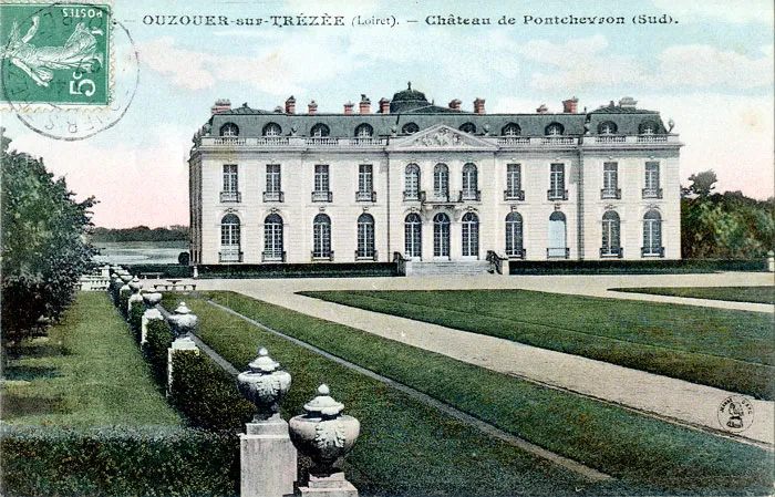
Un château médiéval s'élevait sur une petite île de l'étang. De ce château démoli au début du 19e siècle, ne reste qu'un pont en pierre à deux arches, reliant l'île à la rive. En 1896, la construction du nouveau château est confiée aux architectes Coulomb et Chauvet. Les travaux sont achevés en 1900. L'édifice est formé d'un corps de logis de plan allongé. Il présente, au nord, une rotonde ovale en demi-hors-oeuvre, formant avant-corps central. Les communs sont de plan rectangulaire, ponctué au sud d'un avant-corps central. A l'intérieur, un vaisseau central distribuait les remises à voitures et les écuries. De part et d'autre, et en vis à vis du château, s'étendent deux ailes en quart de cercle, terminées par deux pavillons, celui de l'ouest abritant la chapelle. Si le décor, en façade, se concentre sur les frontons, il n'est pas absent du reste de l'édifice : des clefs sculptées en forme d'agrafes et des guirlandes de fleurs soulignent les baies ; un bossage en table anime le pavement des trumeaux. Tout autour de l'édifice court une balustrade. A l'intérieur, le hall d'entrée présente un décor architecturé rappelant celui des façades. La salle à manger s'orne d'un décor de gypserie peint en faux marbre. Le salon est orné de panneaux sur toile représentant des animaux.
Map and restricted areas
Open in the main mapRestricted zones
Nearby aerodromes
Open aerodromes within 25 km of the spot, heliports included, with their distance and direction from the spot. Near an aerodrome, drone flying is prohibited or height-limited: check the UAS zones map.
| Aerodrome | Type | Distance | Elevation |
|---|---|---|---|
| Briare Chatillon Airport | Aerodrome | 8.3 km S | 164 m |
| Base ULM de Beaulieu-sur-Loire | Aerodrome | 15 km S | 135 m |
Aviation weather (METAR and TAF)
No METAR station within 50 km.
Weather and Kp index
| Day | Weather | Temp. min. / max. | Wind | Rain | Max Kp |
|---|---|---|---|---|---|
| Tue 17 Nov | Cloudy | 11° / 15° | 33 km/h SW | 1.8 mm | 5 |
| Wed 18 Nov | Showers | 10° / 14° | 30 km/h SW | 4.1 mm | 5 |
| Thu 19 Nov | Showers | 9° / 12° | 34 km/h SW | 9.8 mm | 3 |
| Fri 20 Nov | Showers | 9° / 12° | 27 km/h SW | 2.4 mm | 3 |
| Sat 21 Nov | Cloudy | 7° / 11° | 23 km/h SW | 0.1 mm | – |
| Sun 22 Nov | Rain | 6° / 12° | 26 km/h W | 12 mm | – |
| Mon 23 Nov | Fair | 6° / 11° | 25 km/h W | 0.7 mm | – |
Hour by hour: Tuesday 17 November
| Time | Weather | Temp. | Wind | Rain | Clouds | Kp |
|---|---|---|---|---|---|---|
| 15:00 | Cloudy | 15° | 26 km/h SW | – | 100 % | 4 |
| 16:00 | Partly cloudy | 15° | 28 km/h SW | – | 78 % | 4 |
| 17:00 | Partly cloudy | 14° | 28 km/h SW | – | 68 % | 4 |
| 18:00 | Light rain | 14° | 31 km/h SW | 0.1 mm | 90 % | 4 |
| 19:00 | Rain | 13° | 31 km/h SW | 0.5 mm | 90 % | 5 |
| 20:00 | Rain | 12° | 32 km/h SW | 0.9 mm | 100 % | 5 |
| 21:00 | Light rain | 11° | 33 km/h SW | 0.3 mm | 98 % | 5 |
| 22:00 | Cloudy | 12° | 31 km/h SW | – | 100 % | 5 |
Hour by hour: Wednesday 18 November
| Time | Weather | Temp. | Wind | Rain | Clouds | Kp |
|---|---|---|---|---|---|---|
| 06:00 | Partly cloudy | 10° | 25 km/h SW | – | 79 % | 4 |
| 07:00 | Cloudy | 11° | 26 km/h SW | – | 88 % | 4 |
| 08:00 | Cloudy | 10° | 26 km/h SW | – | 100 % | 4 |
| 09:00 | Cloudy | 11° | 27 km/h SW | – | 94 % | 4 |
| 10:00 | Showers | 12° | 26 km/h SW | 0.1 mm | 61 % | 4 |
| 11:00 | Partly cloudy | 12° | 30 km/h SW | – | 49 % | 4 |
| 12:00 | Fair | 13° | 27 km/h SW | – | 27 % | 4 |
| 13:00 | Showers | 14° | 29 km/h SW | 0.1 mm | 23 % | 3 |
| 14:00 | Showers | 13° | 29 km/h SW | 0.8 mm | 48 % | 3 |
| 15:00 | Partly cloudy | 14° | 28 km/h SW | – | 43 % | 3 |
| 16:00 | Clear sky | 13° | 23 km/h SW | – | 10 % | 3 |
| 17:00 | Clear sky | 12° | 22 km/h SW | – | 9 % | 3 |
| 18:00 | Fair | 11° | 21 km/h SW | – | 30 % | 3 |
| 19:00 | Partly cloudy | 11° | 21 km/h SW | – | 85 % | 2 |
| 20:00 | Cloudy | 11° | 21 km/h SW | – | 99 % | 2 |
| 21:00 | Light rain | 11° | 21 km/h SW | 0.1 mm | 100 % | 2 |
| 22:00 | Heavy rain | 11° | 22 km/h S | 1.4 mm | 100 % | 2 |
Sunrise and sunset
| Day | Dawn | Sunrise | Golden hour | Sunset | Dusk | Day length |
|---|---|---|---|---|---|---|
| Tue 17 Nov | 07:24 | 07:57 | 07:57–08:46 · 16:22–17:10 | 17:10 | 17:44 | 9 h 13 |
| Wed 18 Nov | 07:25 | 07:59 | 07:59–08:47 · 16:21–17:09 | 17:09 | 17:43 | 9 h 10 |
| Thu 19 Nov | 07:26 | 08:00 | 08:00–08:49 · 16:20–17:08 | 17:08 | 17:42 | 9 h 08 |
| Fri 20 Nov | 07:28 | 08:02 | 08:02–08:51 · 16:18–17:07 | 17:07 | 17:41 | 9 h 05 |
| Sat 21 Nov | 07:29 | 08:03 | 08:03–08:52 · 16:17–17:07 | 17:07 | 17:41 | 9 h 03 |
| Sun 22 Nov | 07:30 | 08:04 | 08:04–08:54 · 16:16–17:06 | 17:06 | 17:40 | 9 h 01 |
| Mon 23 Nov | 07:32 | 08:06 | 08:06–08:55 · 16:15–17:05 | 17:05 | 17:39 | 8 h 58 |



Reviews (0)
Log in to review this spot. Log in · Create a free account
No reviews yet. Share yours!