

La Rivière Castle
No reviews yet
Have you flown here? Share your experience with other pilots.
+ Write the first reviewHistory
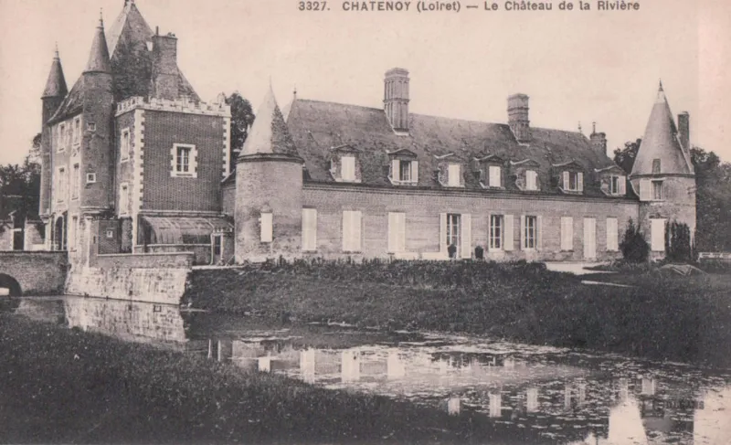
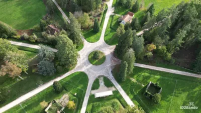
Il existait au Moyen Age un château dont l'emplacement est incertain et qui fut probablement détruit lors de la guerre de Cent ans. Nicolas de Harlay, grand dignitaire de la cour de Henri III et Henri IV, fit construire le château actuel. L'accès se fait par une allée d'arbres conduisant à la façade de briques roses. La construction comprend un donjon carré de deux étages (fin 16e siècle) et un corps de bâtiment qui lui est accolé en équerre au sud (début du 17e siècle). Les douves forment un canal rectangulaire, entourant également la cour au nord et la pelouse au sud. L'entrée se fait par le donjon, précédée d'un pont de pierre ayant remplacé le pont-levis. La façade extérieure du donjon est flanquée de deux tours en poivrière. Un grand portail en anse de panier donne accès au vestibule qui occupe la base du donjon, et débouche dans la cour par un portail identique. La façade sur cour présente à peu près la même ordonnance, moins les tourelles. Le côté nord de la cour était occupé, à l'origine, par les communs qui ont été reportés, au 19e siècle, au-delà de la douve, rejoignant les écuries et le colombier. Au 19e siècle, une tour carrée et crénelée a été accolée à la façade sud du donjon.
Map and restricted areas
Open in the main mapRestricted zones
Nearby aerodromes
Open aerodromes within 25 km of the spot, heliports included, with their distance and direction from the spot. Near an aerodrome, drone flying is prohibited or height-limited: check the UAS zones map.
| Aerodrome | Type | Distance | Elevation |
|---|---|---|---|
| Base ULM de St Benoit sur Loire | Aerodrome | 16 km S | 112 m |
| Orléans – Saint-Denis-de-l'Hôtel Airport | Aerodrome | 19 km W | 121 m |
| Montargis Vimory Airport | Aerodrome | 20 km E | 94 m |
Aviation weather (METAR and TAF)
LFOZ – Orléans – Saint-Denis-de-l'Hôtel Airport MVFR
METAR
METAR LFOZ 171400Z AUTO 21019KT 9999 BKN030 15/11 Q0994
- Wind
- 210°, 35 km/h
- Visibility
- 10 km or more
- Clouds
- Broken (5-7/8) at 3,000 ft (910 m)
- Temperature
- 15 °C, dew point 11 °C
- QNH
- 994 hPa
- Flight category
- MVFR: ceiling 1,000–3,000 ft or visibility 3–5 mi
TAF
Weather and Kp index
Sunrise and sunset
| Day | Dawn | Sunrise | Golden hour | Sunset | Dusk | Day length |
|---|---|---|---|---|---|---|
| Tue 17 Nov | 07:26 | 07:59 | 07:59–08:48 · 16:22–17:11 | 17:11 | 17:45 | 9 h 11 |
| Wed 18 Nov | 07:27 | 08:01 | 08:01–08:50 · 16:21–17:10 | 17:10 | 17:44 | 9 h 09 |
| Thu 19 Nov | 07:28 | 08:02 | 08:02–08:51 · 16:20–17:09 | 17:09 | 17:43 | 9 h 06 |
| Fri 20 Nov | 07:30 | 08:04 | 08:04–08:53 · 16:19–17:08 | 17:08 | 17:42 | 9 h 04 |
| Sat 21 Nov | 07:31 | 08:05 | 08:05–08:55 · 16:18–17:07 | 17:07 | 17:41 | 9 h 01 |
| Sun 22 Nov | 07:32 | 08:07 | 08:07–08:56 · 16:16–17:06 | 17:06 | 17:41 | 8 h 59 |
| Mon 23 Nov | 07:34 | 08:08 | 08:08–08:58 · 16:15–17:05 | 17:05 | 17:40 | 8 h 57 |
Reviews (0)
Log in to review this spot. Log in · Create a free account
No reviews yet. Share yours!