

Gallo-Roman Water Sanctuary of Déversoir
No reviews yet
Have you flown here? Share your experience with other pilots.
+ Write the first reviewHistory
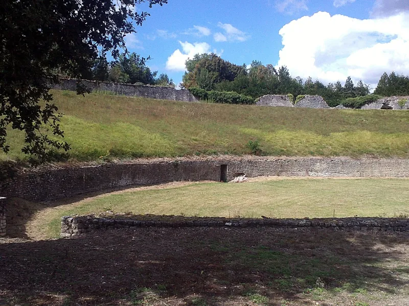
Sanctuaire guérisseur. Un grand quadrilatère construit en petit appareil est bordé sur son pourtour d'une galerie, divisée elle-même en deux rectangles par une galerie médiane. Le mur extérieur a été fortifié de trois tours carrées. En face de l'entrée s'ouvrait, sur la galerie est, une salle carrée dont les trois murs extérieurs sont ornés de pilastres et son sol recouvert d'une mosaïque faite de tesselles blanches et noires. Dans sa partie sud, la galerie périphérique est interrompue par une construction octogonale. Les murs extérieurs sont renforcés de deux contreforts et ornés de 24 colonnes demi-circulaires engagées (en brique et en pierre). Au centre de l'octogone, deux marches permettait d'accéder à un bassin ovale entouré d'une bordure dallée. La source jaillit directement dans cette piscine, protégée elle-même par un bassin rectangulaire. L'évacuation est assurée par deux canalisations, l'une qui traverse l'octogone et aboutit à un bassin carré. Dans le bassin circulaire ont été retrouvés des ex-votos en bois de chêne, représentant différentes parties du corps.
Map and restricted areas
Open in the main mapRestricted zones
Nearby aerodromes
Open aerodromes within 25 km of the spot, heliports included, with their distance and direction from the spot. Near an aerodrome, drone flying is prohibited or height-limited: check the UAS zones map.
| Aerodrome | Type | Distance | Elevation |
|---|---|---|---|
| Montargis Vimory Airport | Aerodrome | 15 km NW | 94 m |
| Centre Hospitalier de l'agglomeration Montargeoise Heliport | Heliport | 15 km N | 108 m |
| Base ULM de Perreux | Aerodrome | 23 km E | 186 m |
Aviation weather (METAR and TAF)
LFOZ – Orléans – Saint-Denis-de-l'Hôtel Airport VFR
METAR
METAR LFOZ 171330Z AUTO 22016KT 9999 SCT032 BKN037 BKN140 16/11 Q0995
- Wind
- 220°, 30 km/h
- Visibility
- 10 km or more
- Clouds
- Scattered (3-4/8) at 3,200 ft (980 m) ; Broken (5-7/8) at 3,700 ft (1130 m) ; Broken (5-7/8) at 14,000 ft (4270 m)
- Temperature
- 16 °C, dew point 11 °C
- QNH
- 995 hPa
- Flight category
- VFR: ceiling > 3,000 ft and visibility > 5 mi
TAF
Weather and Kp index
| Day | Weather | Temp. min. / max. | Wind | Rain | Max Kp |
|---|---|---|---|---|---|
| Tue 17 Nov | Cloudy | 12° / 16° | 33 km/h SW | 3.0 mm | 5 |
| Wed 18 Nov | Partly cloudy | 10° / 14° | 29 km/h SW | 5.4 mm | 5 |
| Thu 19 Nov | Showers | 9° / 13° | 33 km/h SW | 7.2 mm | 3 |
| Fri 20 Nov | Showers | 9° / 13° | 29 km/h SW | 2.9 mm | 3 |
| Sat 21 Nov | Cloudy | 7° / 12° | 24 km/h SW | 0.1 mm | – |
| Sun 22 Nov | Showers | 6° / 11° | 28 km/h W | 14 mm | – |
| Mon 23 Nov | Clear sky | 6° / 11° | 24 km/h W | 0.8 mm | – |
Hour by hour: Tuesday 17 November
| Time | Weather | Temp. | Wind | Rain | Clouds | Kp |
|---|---|---|---|---|---|---|
| 15:00 | Cloudy | 16° | 28 km/h SW | – | 100 % | 4 |
| 16:00 | Cloudy | 15° | 28 km/h SW | – | 96 % | 4 |
| 17:00 | Partly cloudy | 15° | 28 km/h SW | – | 85 % | 4 |
| 18:00 | Light rain | 14° | 30 km/h SW | 0.3 mm | 99 % | 4 |
| 19:00 | Rain | 14° | 31 km/h SW | 0.5 mm | 88 % | 5 |
| 20:00 | Heavy rain | 12° | 31 km/h SW | 1.4 mm | 100 % | 5 |
| 21:00 | Light rain | 12° | 33 km/h SW | 0.2 mm | 98 % | 5 |
| 22:00 | Light rain | 12° | 31 km/h SW | 0.3 mm | 100 % | 5 |
Hour by hour: Wednesday 18 November
| Time | Weather | Temp. | Wind | Rain | Clouds | Kp |
|---|---|---|---|---|---|---|
| 06:00 | Showers | 10° | 24 km/h SW | 0.1 mm | 76 % | 4 |
| 07:00 | Light rain | 11° | 25 km/h SW | 0.2 mm | 96 % | 4 |
| 08:00 | Cloudy | 10° | 24 km/h SW | – | 100 % | 4 |
| 09:00 | Cloudy | 11° | 27 km/h SW | – | 99 % | 4 |
| 10:00 | Partly cloudy | 11° | 26 km/h SW | – | 79 % | 4 |
| 11:00 | Partly cloudy | 12° | 28 km/h SW | – | 41 % | 4 |
| 12:00 | Fair | 13° | 26 km/h SW | – | 26 % | 4 |
| 13:00 | Partly cloudy | 14° | 28 km/h SW | – | 53 % | 3 |
| 14:00 | Showers | 13° | 29 km/h SW | 1.1 mm | 74 % | 3 |
| 15:00 | Fair | 12° | 25 km/h SW | – | 36 % | 3 |
| 16:00 | Clear sky | 13° | 23 km/h SW | – | 11 % | 3 |
| 17:00 | Clear sky | 12° | 22 km/h SW | – | 9 % | 3 |
| 18:00 | Fair | 12° | 20 km/h SW | – | 29 % | 3 |
| 19:00 | Partly cloudy | 11° | 20 km/h SW | – | 84 % | 2 |
| 20:00 | Cloudy | 11° | 20 km/h SW | – | 99 % | 2 |
| 21:00 | Rain | 11° | 21 km/h S | 0.6 mm | 100 % | 2 |
| 22:00 | Heavy rain | 11° | 21 km/h S | 1.4 mm | 100 % | 2 |
Sunrise and sunset
| Day | Dawn | Sunrise | Golden hour | Sunset | Dusk | Day length |
|---|---|---|---|---|---|---|
| Tue 17 Nov | 07:24 | 07:58 | 07:58–08:46 · 16:21–17:10 | 17:10 | 17:44 | 9 h 12 |
| Wed 18 Nov | 07:25 | 07:59 | 07:59–08:48 · 16:20–17:09 | 17:09 | 17:43 | 9 h 09 |
| Thu 19 Nov | 07:26 | 08:01 | 08:01–08:50 · 16:19–17:08 | 17:08 | 17:42 | 9 h 07 |
| Fri 20 Nov | 07:28 | 08:02 | 08:02–08:51 · 16:17–17:07 | 17:07 | 17:41 | 9 h 04 |
| Sat 21 Nov | 07:29 | 08:03 | 08:03–08:53 · 16:16–17:06 | 17:06 | 17:40 | 9 h 02 |
| Sun 22 Nov | 07:30 | 08:05 | 08:05–08:55 · 16:15–17:05 | 17:05 | 17:39 | 8 h 59 |
| Mon 23 Nov | 07:32 | 08:06 | 08:06–08:56 · 16:14–17:04 | 17:04 | 17:38 | 8 h 57 |


Reviews (0)
Log in to review this spot. Log in · Create a free account
No reviews yet. Share yours!