

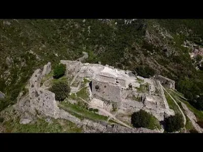
Carbonac Tower
No reviews yet
Have you flown here? Share your experience with other pilots.
+ Write the first reviewHistory
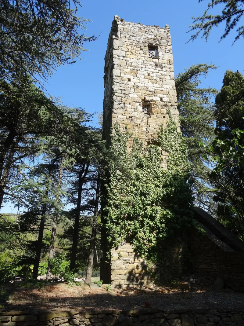
Le nom de Carbonac apparaît dans une cession de 1257 par le sénéchal à l'évêque de Carcassonne, de certaines rentes à Carbonac. Le dénombrement de 1500 mentionne une tour ancienne avec haute, moyenne et basse justice. Pour une petite seigneurie placée dans des conditions défensives défavorables, cette tour étroite de plan presque carré aurait pu servir de tour de guet. A la base, les assises sont de petit appareil, irrégulier. Vers le haut, quelques assises plus régulières sont en appareil moyen. Les seules ouvertures, rectangulaires, sont relativement récentes. Toiture en voûte de blocage. La base serait occupée par une petite salle voûtée en berceau. Le degré extérieur, construit pour accéder à la porte, n'est pas ancien.
Map and restricted areas
Open in the main mapRestricted zones
| Zone | Category | Limits | Conditions |
|---|---|---|---|
| Istres | Zone réglementée | 5491 m above sea level → 30766 m above sea level | Vols interdits sauf lorsque the official document of the zone l'autorise explicitement ou avec l'accord du gestionnaire de la zone lorsqu'il est désigné par the official document of the zone |
| TMA 7 TOULOUSE temporaire |
ZRT | FL 065 / FL 115 | SUP AIP AIRAC 180/26 · Du jeudi 01 octobre 2026 au mercredi 14 avril 2027 |
Nearby aerodromes
Open aerodromes within 25 km of the spot, heliports included, with their distance and direction from the spot. Near an aerodrome, drone flying is prohibited or height-limited: check the UAS zones map.
| Aerodrome | Type | Distance | Elevation |
|---|---|---|---|
| Gayraud Centre Hospitalier Heliport | Heliport | 12 km NW | 145 m |
| Carcassonne Airport | Airport | 16 km NW | 132 m |
| Lézignan-Corbières Airfield | Aerodrome | 21 km E | 63 m |
| Ulmodrome de Limoux | Aerodrome | 23 km SW | 183 m |
Aviation weather (METAR and TAF)
LFMK – Carcassonne Airport VFR
METAR
METAR LFMK 171330Z AUTO VRB03KT 9999 FEW028/// SCT130/// ///TCU 15/14 Q1004 NOSIG
- Wind
- Variable, 6 km/h
- Visibility
- 10 km or more
- Clouds
- Few (1-2/8) at 2,800 ft (850 m) ; Scattered (3-4/8) at 13,000 ft (3960 m)
- Temperature
- 15 °C, dew point 14 °C
- QNH
- 1004 hPa
- Flight category
- VFR: ceiling > 3,000 ft and visibility > 5 mi
TAF
TAF LFMK 170800Z 1709/1809 08008KT 9999 BKN070 TEMPO 1709/1712 -RA SCT004 BKN010 BECMG 1710/1712 VRB03KT TEMPO 1712/1720 SCT025TCU BECMG 1720/1722 CAVOK PROB30 TEMPO 1801/1807 3000 BR BECMG 1806/1808 27010KT 4000 RA BKN020 BKN030
| Period (local time) | Change | Wind | Visibility | Weather | Clouds |
|---|---|---|---|---|---|
| 17/11 10:00 → 17/11 11:00 | Initial conditions | 080°, 15 km/h | 10 km or more | Broken (5-7/8) at 7,000 ft (2130 m) | |
| 17/11 10:00 → 17/11 13:00 | Temporarily | Rain light | Scattered (3-4/8) at 400 ft (120 m) ; Broken (5-7/8) at 1,000 ft (300 m) | ||
| 17/11 11:00 → 17/11 21:00 | Becoming | Variable, 6 km/h | 10 km or more | Broken (5-7/8) at 7,000 ft (2130 m) | |
| 17/11 13:00 → 17/11 21:00 | Temporarily | Scattered (3-4/8) at 2,500 ft (760 m) (towering cumulus) | |||
| 17/11 21:00 → 18/11 07:00 | Becoming | Variable, 6 km/h | 10 km or more | No significant weather | No significant cloud |
| 18/11 02:00 → 18/11 08:00 | Temporarily, probability 30% | 3.0 km | Mist | ||
| 18/11 07:00 → 18/11 10:00 | Becoming | 270°, 19 km/h | 4.0 km | Rain | Broken (5-7/8) at 2,000 ft (610 m) ; Broken (5-7/8) at 3,000 ft (910 m) |
Weather and Kp index
| Day | Weather | Temp. min. / max. | Wind | Rain | Max Kp |
|---|---|---|---|---|---|
| Tue 17 Nov | Light rain | 12° / 15° | 12 km/h SW | 0.1 mm | 5 |
| Wed 18 Nov | Fair | 10° / 18° | 26 km/h W | 1.9 mm | 5 |
| Thu 19 Nov | Clear sky | 10° / 16° | 36 km/h W | 3.1 mm | 3 |
| Fri 20 Nov | Partly cloudy | 9° / 16° | 29 km/h W | – | 3 |
| Sat 21 Nov | Cloudy | 8° / 15° | 15 km/h E | – | – |
| Sun 22 Nov | Fair | 12° / 14° | 33 km/h W | 1.0 mm | – |
| Mon 23 Nov | Cloudy | 8° / 14° | 21 km/h W | – | – |
Hour by hour: Tuesday 17 November
| Time | Weather | Temp. | Wind | Rain | Clouds | Kp |
|---|---|---|---|---|---|---|
| 15:00 | Light rain | 15° | 12 km/h SW | 0.1 mm | 100 % | 4 |
| 16:00 | Cloudy | 15° | 6 km/h SW | – | 100 % | 4 |
| 17:00 | Cloudy | 15° | 5 km/h NW | – | 100 % | 4 |
| 18:00 | Cloudy | 14° | 4 km/h NW | – | 100 % | 4 |
| 19:00 | Cloudy | 13° | 3 km/h W | – | 94 % | 5 |
| 20:00 | Cloudy | 12° | 4 km/h NW | – | 98 % | 5 |
| 21:00 | Cloudy | 12° | 5 km/h W | – | 98 % | 5 |
| 22:00 | Cloudy | 12° | 6 km/h SW | – | 97 % | 5 |
Hour by hour: Wednesday 18 November
| Time | Weather | Temp. | Wind | Rain | Clouds | Kp |
|---|---|---|---|---|---|---|
| 06:00 | Light rain | 12° | 10 km/h SW | 0.3 mm | 100 % | 4 |
| 07:00 | Rain | 12° | 13 km/h SW | 1.0 mm | 100 % | 4 |
| 08:00 | Rain | 12° | 21 km/h W | 0.4 mm | 100 % | 4 |
| 09:00 | Light rain | 13° | 25 km/h W | 0.2 mm | 100 % | 4 |
| 10:00 | Cloudy | 14° | 26 km/h W | – | 100 % | 4 |
| 11:00 | Cloudy | 14° | 23 km/h W | – | 100 % | 4 |
| 12:00 | Partly cloudy | 15° | 24 km/h W | – | 45 % | 4 |
| 13:00 | Fair | 17° | 23 km/h W | – | 16 % | 3 |
| 14:00 | Clear sky | 18° | 22 km/h W | – | 2 % | 3 |
| 15:00 | Fair | 18° | 20 km/h W | – | 19 % | 3 |
| 16:00 | Partly cloudy | 17° | 17 km/h W | – | 56 % | 3 |
| 17:00 | Partly cloudy | 16° | 12 km/h W | – | 52 % | 3 |
| 18:00 | Partly cloudy | 13° | 9 km/h SW | – | 87 % | 3 |
| 19:00 | Partly cloudy | 12° | 8 km/h SW | – | 75 % | 2 |
| 20:00 | Partly cloudy | 11° | 9 km/h E | – | 84 % | 2 |
| 21:00 | Cloudy | 11° | 13 km/h E | – | 92 % | 2 |
| 22:00 | Cloudy | 12° | 16 km/h NE | – | 95 % | 2 |
Sunrise and sunset
| Day | Dawn | Sunrise | Golden hour | Sunset | Dusk | Day length |
|---|---|---|---|---|---|---|
| Tue 17 Nov | 07:15 | 07:45 | 07:45–08:29 · 16:42–17:25 | 17:25 | 17:55 | 9 h 39 |
| Wed 18 Nov | 07:16 | 07:47 | 07:47–08:30 · 16:41–17:24 | 17:24 | 17:55 | 9 h 37 |
| Thu 19 Nov | 07:17 | 07:48 | 07:48–08:31 · 16:40–17:23 | 17:23 | 17:54 | 9 h 35 |
| Fri 20 Nov | 07:18 | 07:49 | 07:49–08:33 · 16:39–17:22 | 17:22 | 17:53 | 9 h 33 |
| Sat 21 Nov | 07:19 | 07:50 | 07:50–08:34 · 16:38–17:22 | 17:22 | 17:53 | 9 h 31 |
| Sun 22 Nov | 07:20 | 07:52 | 07:52–08:35 · 16:37–17:21 | 17:21 | 17:52 | 9 h 29 |
| Mon 23 Nov | 07:22 | 07:53 | 07:53–08:37 · 16:36–17:20 | 17:20 | 17:51 | 9 h 27 |
Reviews (0)
Log in to review this spot. Log in · Create a free account
No reviews yet. Share yours!