

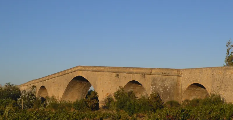
Bridge of the Estates of Languedoc
No reviews yet
Have you flown here? Share your experience with other pilots.
+ Write the first reviewHistory
Par son faible débit d'étiage, l'Orbieu ne paraissait pas justifier un travail de cette ampleur, mais les crues subites de ce cours d'eau ayant détruit plusieurs ouvrages successifs, on décida de le franchir à une hauteur suffisante pour éliminer tout danger. L'importance du devis excédant les moyens des localités et du diocèse de Narbonne, on eut recours aux Etats de Languedoc. Un premier projet, établi en 1745, situait le pont en aval, à Villedaigne, mais faisait allonger le tracé de la route prévue de Narbonne à Lézignan. En mars 1746 fut approuvé le projet de l'ingéneiur Carney. Les premiers travaux révélèrent que le roc était moins solide qu'il ne paraissait. La pile qui devait recevoir la retombée des deux arches centrales s'affaissait. Il fallut se résoudre à remplacer les eux grandes arches prévues par trois arches. En 1752, Garipuy remplace Carney, décédé.££L'ouvrage est à cinq arches en plein cintre. La cote du sommet de l'arche centrale est à 13m, celle des arches latérales à 6, d'où une pente assez accusée pour les avenues. Toutes les arches sont en pierre d'appareil, ainsi que les murs de la partie centrale. Seuls les murs latéraux, au-dessus des petites arches, sont en moellons. Les deux piles médianes, dans le cours d'eau, présentent des éperons triangulaires en pierre d'appareil. A l'arche médiane, les clefs, à l'amont comme à l'aval, sont ornées d'un grand cartouche sculpté aux armes des Etats de Languedoc. Les claveaux des trois grandes arches sont alternativement longs et courts. Un bandeau extérieur, en boudin, court à la base du parapet.
Map and restricted areas
Open in the main mapRestricted zones
| Zone | Category | Limits | Conditions |
|---|---|---|---|
| R 46 E2 | Zone réglementée | 244 m above ground level → 853 m above sea level | Vols interdits sauf lorsque the official document of the zone l'autorise explicitement ou avec l'accord du gestionnaire de la zone lorsqu'il est désigné par the official document of the zone |
| Istres | Zone réglementée | 5491 m above sea level → 30766 m above sea level | Vols interdits sauf lorsque the official document of the zone l'autorise explicitement ou avec l'accord du gestionnaire de la zone lorsqu'il est désigné par the official document of the zone |
| Istres | Zone réglementée | 5491 m above sea level → 30766 m above sea level | Vols interdits sauf lorsque the official document of the zone l'autorise explicitement ou avec l'accord du gestionnaire de la zone lorsqu'il est désigné par the official document of the zone |
| Zrt/zdt Lima 2 | ZRT/ZDT | FL 195 / FL 285 | SUP AIP 219/26 · Du mardi 20 octobre au jeudi 22 octobre 2026 |
Nearby aerodromes
Open aerodromes within 25 km of the spot, heliports included, with their distance and direction from the spot. Near an aerodrome, drone flying is prohibited or height-limited: check the UAS zones map.
| Aerodrome | Type | Distance | Elevation |
|---|---|---|---|
| Lézignan-Corbières Airfield | Aerodrome | 8.2 km W | 63 m |
| St Crescent Heliport | Heliport | 13 km E | 9 m |
| Narbonne | Aerodrome | 18 km E | 3 m |
Aviation weather (METAR and TAF)
LFMK – Carcassonne Airport VFR
METAR
METAR LFMK 171400Z AUTO VRB03KT 9999 FEW092/// BKN120/// ///TCU 15/14 Q1004 NOSIG
- Wind
- Variable, 6 km/h
- Visibility
- 10 km or more
- Clouds
- Few (1-2/8) at 9,200 ft (2800 m) ; Broken (5-7/8) at 12,000 ft (3660 m)
- Temperature
- 15 °C, dew point 14 °C
- QNH
- 1004 hPa
- Flight category
- VFR: ceiling > 3,000 ft and visibility > 5 mi
TAF
TAF LFMK 170800Z 1709/1809 08008KT 9999 BKN070 TEMPO 1709/1712 -RA SCT004 BKN010 BECMG 1710/1712 VRB03KT TEMPO 1712/1720 SCT025TCU BECMG 1720/1722 CAVOK PROB30 TEMPO 1801/1807 3000 BR BECMG 1806/1808 27010KT 4000 RA BKN020 BKN030
| Period (local time) | Change | Wind | Visibility | Weather | Clouds |
|---|---|---|---|---|---|
| 17/11 10:00 → 17/11 11:00 | Initial conditions | 080°, 15 km/h | 10 km or more | Broken (5-7/8) at 7,000 ft (2130 m) | |
| 17/11 10:00 → 17/11 13:00 | Temporarily | Rain light | Scattered (3-4/8) at 400 ft (120 m) ; Broken (5-7/8) at 1,000 ft (300 m) | ||
| 17/11 11:00 → 17/11 21:00 | Becoming | Variable, 6 km/h | 10 km or more | Broken (5-7/8) at 7,000 ft (2130 m) | |
| 17/11 13:00 → 17/11 21:00 | Temporarily | Scattered (3-4/8) at 2,500 ft (760 m) (towering cumulus) | |||
| 17/11 21:00 → 18/11 07:00 | Becoming | Variable, 6 km/h | 10 km or more | No significant weather | No significant cloud |
| 18/11 02:00 → 18/11 08:00 | Temporarily, probability 30% | 3.0 km | Mist | ||
| 18/11 07:00 → 18/11 10:00 | Becoming | 270°, 19 km/h | 4.0 km | Rain | Broken (5-7/8) at 2,000 ft (610 m) ; Broken (5-7/8) at 3,000 ft (910 m) |
Weather and Kp index
| Day | Weather | Temp. min. / max. | Wind | Rain | Max Kp |
|---|---|---|---|---|---|
| Tue 17 Nov | Light rain | 12° / 16° | 13 km/h SW | 0.1 mm | 5 |
| Wed 18 Nov | Clear sky | 11° / 18° | 34 km/h W | 1.1 mm | 5 |
| Thu 19 Nov | Clear sky | 12° / 17° | 39 km/h W | 2.4 mm | 3 |
| Fri 20 Nov | Partly cloudy | 10° / 17° | 28 km/h W | – | 3 |
| Sat 21 Nov | Cloudy | 9° / 16° | 13 km/h NE | – | – |
| Sun 22 Nov | Fair | 12° / 15° | 36 km/h W | 0.5 mm | – |
| Mon 23 Nov | Cloudy | 9° / 15° | 19 km/h W | 0.1 mm | – |
Hour by hour: Tuesday 17 November
| Time | Weather | Temp. | Wind | Rain | Clouds | Kp |
|---|---|---|---|---|---|---|
| 15:00 | Light rain | 16° | 13 km/h SW | 0.1 mm | 100 % | 4 |
| 16:00 | Cloudy | 16° | 10 km/h SW | – | 100 % | 4 |
| 17:00 | Cloudy | 16° | 5 km/h NW | – | 100 % | 4 |
| 18:00 | Cloudy | 15° | 4 km/h NE | – | 99 % | 4 |
| 19:00 | Cloudy | 14° | 5 km/h NE | – | 94 % | 5 |
| 20:00 | Cloudy | 13° | 6 km/h N | – | 88 % | 5 |
| 21:00 | Cloudy | 13° | 9 km/h NW | – | 98 % | 5 |
| 22:00 | Cloudy | 12° | 5 km/h W | – | 94 % | 5 |
Hour by hour: Wednesday 18 November
| Time | Weather | Temp. | Wind | Rain | Clouds | Kp |
|---|---|---|---|---|---|---|
| 06:00 | Cloudy | 12° | 9 km/h SW | – | 100 % | 4 |
| 07:00 | Rain | 12° | 10 km/h SW | 0.6 mm | 100 % | 4 |
| 08:00 | Rain | 13° | 23 km/h W | 0.4 mm | 100 % | 4 |
| 09:00 | Light rain | 14° | 31 km/h W | 0.1 mm | 100 % | 4 |
| 10:00 | Partly cloudy | 15° | 34 km/h W | – | 80 % | 4 |
| 11:00 | Partly cloudy | 16° | 32 km/h W | – | 85 % | 4 |
| 12:00 | Fair | 16° | 29 km/h W | – | 33 % | 4 |
| 13:00 | Clear sky | 17° | 26 km/h W | – | 11 % | 3 |
| 14:00 | Clear sky | 18° | 24 km/h W | – | 3 % | 3 |
| 15:00 | Clear sky | 18° | 21 km/h W | – | 12 % | 3 |
| 16:00 | Partly cloudy | 18° | 18 km/h W | – | 66 % | 3 |
| 17:00 | Partly cloudy | 16° | 14 km/h W | – | 46 % | 3 |
| 18:00 | Partly cloudy | 14° | 9 km/h SW | – | 70 % | 3 |
| 19:00 | Partly cloudy | 13° | 10 km/h SW | – | 69 % | 2 |
| 20:00 | Partly cloudy | 12° | 11 km/h S | – | 82 % | 2 |
| 21:00 | Partly cloudy | 13° | 12 km/h SE | – | 70 % | 2 |
| 22:00 | Cloudy | 13° | 15 km/h SE | – | 92 % | 2 |
Sunrise and sunset
| Day | Dawn | Sunrise | Golden hour | Sunset | Dusk | Day length |
|---|---|---|---|---|---|---|
| Tue 17 Nov | 07:13 | 07:44 | 07:44–08:27 · 16:40–17:23 | 17:23 | 17:54 | 9 h 39 |
| Wed 18 Nov | 07:15 | 07:45 | 07:45–08:29 · 16:39–17:22 | 17:22 | 17:53 | 9 h 37 |
| Thu 19 Nov | 07:16 | 07:47 | 07:47–08:30 · 16:38–17:22 | 17:22 | 17:52 | 9 h 34 |
| Fri 20 Nov | 07:17 | 07:48 | 07:48–08:31 · 16:37–17:21 | 17:21 | 17:52 | 9 h 32 |
| Sat 21 Nov | 07:18 | 07:49 | 07:49–08:33 · 16:36–17:20 | 17:20 | 17:51 | 9 h 30 |
| Sun 22 Nov | 07:19 | 07:50 | 07:50–08:34 · 16:35–17:19 | 17:19 | 17:50 | 9 h 29 |
| Mon 23 Nov | 07:20 | 07:51 | 07:51–08:36 · 16:35–17:19 | 17:19 | 17:50 | 9 h 27 |

Reviews (0)
Log in to review this spot. Log in · Create a free account
No reviews yet. Share yours!