

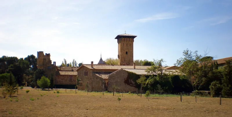
Gaussan Castle
No reviews yet
Have you flown here? Share your experience with other pilots.
+ Write the first reviewHistory
14e siècle ; 19e siècle En 1178, la chapelle rurale Saint-Etienne-de-Gaudia fut unie au prieuré régulier de Sainte-Eugénie. A la fin du 12e siècle, ce prieuré fut acquis avec la chapelle par le monastère de Fontfroide qui y établit, dès le 13e siècle, une ferme fortifiée. La ferme restera possession de Fontfroide jusqu'au 18e siècle. En 1791, tous les biens de l'abbaye sont mis sous séquestre, y compris la métairie de Gaussan, vendue la même année. L'actuel château correspond à un ensemble important de bâtiments, pour la plupart à vocation viticole et construits au 19e siècle. Le terme "château" s'attache plus particulièrement à quatre corps de bâtiments qui ferment une cour intérieure rectangulaire, très largement remaniés au 19e siècle mais dont le gros-oeuvre date majoritairement du 14e. Les façades Est et Sud sont couronnées par un système de défense établi au 19e siècle, à créneaux sur mâchicoulis, semblant reprendre un dispositif existant au préalable, les corbeaux formés de trois quart-de-rond en encorbellement étant d'origine. La porte d'entrée est constituée d'un arc de tête en plein cintre au revers duquel a été ménagée une gaine permettant le mouvement de la herse, et un deuxième arc plein cintre plus bas que le premier. Cette façade est cantonnée par deux échauguettes d'angle en encorbellement, remaniées au 19e siècle. Les façades sur cour, du 14e siècle, ont été remaniées au 19e siècle, notamment en ce qui concerne l'ordonnance des ouvertures. Le corps de bâtiment central se compose, en rez-de-chaussée, d'une vaste salle couverte en berceau brisé, de la fin du 13e - 14e siècle. L'étage est occupé par une chapelle désaffectée, aménagée au 19e siècle. Le corps d'habitation est placé dans le bâtiment sud. Au premier étage se trouve la chambre dite de "l'évêque", couverte d'une fausse voûte d'ogives à liernes et tiercerons. Au rez-de-chaussée, l'ensemble des pièces est plafonné à la française, à l'exception de la salle à manger et de la cage d'escalier voûtées. La tour nord-ouest, ou donjon, sur plan rectangulaire, est munie d'archères et couronnée par un rang de mâchicoulis sur corbeaux en encorbellement. Ces derniers sont d'origine tandis que les arcatures sont le résultat d'aménagements du 19e siècle. Les mâchicoulis portaient autrefois des créneaux qui ont été démolis par mesure de sécurité.
Map and restricted areas
Open in the main mapRestricted zones
| Zone | Category | Limits | Conditions |
|---|---|---|---|
| R 46 E2 | Zone réglementée | 244 m above ground level → 853 m above sea level | Vols interdits sauf lorsque the official document of the zone l'autorise explicitement ou avec l'accord du gestionnaire de la zone lorsqu'il est désigné par the official document of the zone |
| Istres | Zone réglementée | 5491 m above sea level → 30766 m above sea level | Vols interdits sauf lorsque the official document of the zone l'autorise explicitement ou avec l'accord du gestionnaire de la zone lorsqu'il est désigné par the official document of the zone |
| Istres | Zone réglementée | 5491 m above sea level → 30766 m above sea level | Vols interdits sauf lorsque the official document of the zone l'autorise explicitement ou avec l'accord du gestionnaire de la zone lorsqu'il est désigné par the official document of the zone |
| Zrt/zdt Lima 2 | ZRT/ZDT | FL 195 / FL 285 | SUP AIP 219/26 · Du mardi 20 octobre au jeudi 22 octobre 2026 |
Nearby aerodromes
Open aerodromes within 25 km of the spot, heliports included, with their distance and direction from the spot. Near an aerodrome, drone flying is prohibited or height-limited: check the UAS zones map.
| Aerodrome | Type | Distance | Elevation |
|---|---|---|---|
| Lézignan-Corbières Airfield | Aerodrome | 9.9 km NW | 63 m |
| St Crescent Heliport | Heliport | 13 km E | 9 m |
| Narbonne | Aerodrome | 18 km E | 3 m |
Aviation weather (METAR and TAF)
LFMK – Carcassonne Airport VFR
METAR
METAR LFMK 171330Z AUTO VRB03KT 9999 FEW028/// SCT130/// ///TCU 15/14 Q1004 NOSIG
- Wind
- Variable, 6 km/h
- Visibility
- 10 km or more
- Clouds
- Few (1-2/8) at 2,800 ft (850 m) ; Scattered (3-4/8) at 13,000 ft (3960 m)
- Temperature
- 15 °C, dew point 14 °C
- QNH
- 1004 hPa
- Flight category
- VFR: ceiling > 3,000 ft and visibility > 5 mi
TAF
TAF LFMK 170800Z 1709/1809 08008KT 9999 BKN070 TEMPO 1709/1712 -RA SCT004 BKN010 BECMG 1710/1712 VRB03KT TEMPO 1712/1720 SCT025TCU BECMG 1720/1722 CAVOK PROB30 TEMPO 1801/1807 3000 BR BECMG 1806/1808 27010KT 4000 RA BKN020 BKN030
| Period (local time) | Change | Wind | Visibility | Weather | Clouds |
|---|---|---|---|---|---|
| 17/11 10:00 → 17/11 11:00 | Initial conditions | 080°, 15 km/h | 10 km or more | Broken (5-7/8) at 7,000 ft (2130 m) | |
| 17/11 10:00 → 17/11 13:00 | Temporarily | Rain light | Scattered (3-4/8) at 400 ft (120 m) ; Broken (5-7/8) at 1,000 ft (300 m) | ||
| 17/11 11:00 → 17/11 21:00 | Becoming | Variable, 6 km/h | 10 km or more | Broken (5-7/8) at 7,000 ft (2130 m) | |
| 17/11 13:00 → 17/11 21:00 | Temporarily | Scattered (3-4/8) at 2,500 ft (760 m) (towering cumulus) | |||
| 17/11 21:00 → 18/11 07:00 | Becoming | Variable, 6 km/h | 10 km or more | No significant weather | No significant cloud |
| 18/11 02:00 → 18/11 08:00 | Temporarily, probability 30% | 3.0 km | Mist | ||
| 18/11 07:00 → 18/11 10:00 | Becoming | 270°, 19 km/h | 4.0 km | Rain | Broken (5-7/8) at 2,000 ft (610 m) ; Broken (5-7/8) at 3,000 ft (910 m) |
Weather and Kp index
| Day | Weather | Temp. min. / max. | Wind | Rain | Max Kp |
|---|---|---|---|---|---|
| Tue 17 Nov | Light rain | 12° / 16° | 13 km/h W | 0.2 mm | 5 |
| Wed 18 Nov | Clear sky | 10° / 18° | 35 km/h W | 0.6 mm | 5 |
| Thu 19 Nov | Clear sky | 12° / 16° | 39 km/h W | 1.7 mm | 3 |
| Fri 20 Nov | Partly cloudy | 10° / 17° | 27 km/h W | – | 3 |
| Sat 21 Nov | Cloudy | 10° / 16° | 12 km/h W | 0.2 mm | – |
| Sun 22 Nov | Clear sky | 11° / 15° | 33 km/h W | 0.2 mm | – |
| Mon 23 Nov | Cloudy | 10° / 14° | 20 km/h W | – | – |
Hour by hour: Tuesday 17 November
| Time | Weather | Temp. | Wind | Rain | Clouds | Kp |
|---|---|---|---|---|---|---|
| 15:00 | Light rain | 16° | 13 km/h W | 0.2 mm | 100 % | 4 |
| 16:00 | Cloudy | 16° | 9 km/h S | – | 100 % | 4 |
| 17:00 | Cloudy | 15° | 2 km/h NE | – | 99 % | 4 |
| 18:00 | Cloudy | 14° | 5 km/h NE | – | 100 % | 4 |
| 19:00 | Cloudy | 14° | 6 km/h W | – | 95 % | 5 |
| 20:00 | Cloudy | 13° | 6 km/h W | – | 88 % | 5 |
| 21:00 | Partly cloudy | 12° | 9 km/h NW | – | 84 % | 5 |
| 22:00 | Cloudy | 12° | 5 km/h W | – | 90 % | 5 |
Hour by hour: Wednesday 18 November
| Time | Weather | Temp. | Wind | Rain | Clouds | Kp |
|---|---|---|---|---|---|---|
| 06:00 | Cloudy | 12° | 9 km/h SW | – | 100 % | 4 |
| 07:00 | Rain | 12° | 11 km/h W | 0.4 mm | 100 % | 4 |
| 08:00 | Light rain | 13° | 23 km/h W | 0.2 mm | 100 % | 4 |
| 09:00 | Partly cloudy | 14° | 31 km/h W | – | 83 % | 4 |
| 10:00 | Partly cloudy | 15° | 35 km/h W | – | 66 % | 4 |
| 11:00 | Fair | 16° | 34 km/h W | – | 38 % | 4 |
| 12:00 | Fair | 16° | 29 km/h W | – | 34 % | 4 |
| 13:00 | Clear sky | 17° | 26 km/h W | – | 6 % | 3 |
| 14:00 | Clear sky | 18° | 25 km/h W | – | 4 % | 3 |
| 15:00 | Clear sky | 18° | 21 km/h W | – | 7 % | 3 |
| 16:00 | Partly cloudy | 18° | 18 km/h W | – | 68 % | 3 |
| 17:00 | Partly cloudy | 16° | 14 km/h W | – | 73 % | 3 |
| 18:00 | Partly cloudy | 14° | 9 km/h SW | – | 76 % | 3 |
| 19:00 | Partly cloudy | 13° | 10 km/h S | – | 66 % | 2 |
| 20:00 | Partly cloudy | 13° | 12 km/h S | – | 83 % | 2 |
| 21:00 | Partly cloudy | 14° | 14 km/h S | – | 85 % | 2 |
| 22:00 | Partly cloudy | 14° | 16 km/h S | – | 90 % | 2 |
Sunrise and sunset
| Day | Dawn | Sunrise | Golden hour | Sunset | Dusk | Day length |
|---|---|---|---|---|---|---|
| Tue 17 Nov | 07:13 | 07:44 | 07:44–08:27 · 16:40–17:23 | 17:23 | 17:54 | 9 h 39 |
| Wed 18 Nov | 07:14 | 07:45 | 07:45–08:28 · 16:39–17:22 | 17:22 | 17:53 | 9 h 37 |
| Thu 19 Nov | 07:16 | 07:46 | 07:46–08:30 · 16:38–17:22 | 17:22 | 17:52 | 9 h 35 |
| Fri 20 Nov | 07:17 | 07:48 | 07:48–08:31 · 16:37–17:21 | 17:21 | 17:52 | 9 h 33 |
| Sat 21 Nov | 07:18 | 07:49 | 07:49–08:33 · 16:36–17:20 | 17:20 | 17:51 | 9 h 31 |
| Sun 22 Nov | 07:19 | 07:50 | 07:50–08:34 · 16:36–17:19 | 17:19 | 17:50 | 9 h 29 |
| Mon 23 Nov | 07:20 | 07:51 | 07:51–08:35 · 16:35–17:19 | 17:19 | 17:50 | 9 h 27 |
Reviews (0)
Log in to review this spot. Log in · Create a free account
No reviews yet. Share yours!