

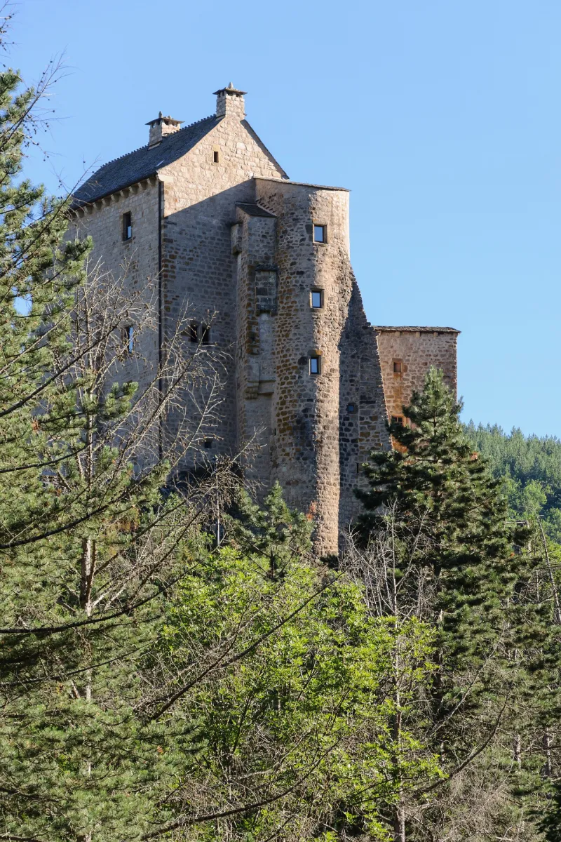
Miral Castle
No reviews yet
Have you flown here? Share your experience with other pilots.
+ Write the first reviewHistory
Remontant au 13e siècle, le château a été étroitement lié à l'histoire des troubles et guerres ayant touché le Gévaudan pendant cinq siècles. L'ensemble fortifié comprend un vaste donjon carré flanqué d'une haute tour ronde sur un côté, diverses constructions annexes et ouvrages de défense. L'époque Renaissance est représentée par les fenêtres à meneaux de l'ancienne demeure seigneuriale ainsi que les peintures murales intérieures (chapelle, bâtiment ouest). Ce château fort est un témoin de l'architecture militaire des 13e et 14e siècles avec aménagement d'un site naturel défensif, double enceinte, donjon et importante seigneurie locale qui exploitait des mines d'argent voisines. Il conserve également des décors sculptés et peints qui en font l'un des rares édifices civiles de cette région à en avoir conservé.
Map and restricted areas
Open in the main mapRestricted zones
| Zone | Category | Limits | Conditions |
|---|---|---|---|
| Rhone | Zone réglementée | 1529 m above sea level → 6259 m above sea level | Vols interdits sauf lorsque the official document of the zone l'autorise explicitement ou avec l'accord du gestionnaire de la zone lorsqu'il est désigné par the official document of the zone |
| Istres | Zone réglementée | 5491 m above sea level → 30766 m above sea level | Vols interdits sauf lorsque the official document of the zone l'autorise explicitement ou avec l'accord du gestionnaire de la zone lorsqu'il est désigné par the official document of the zone |
| Istres | Zone réglementée | 5491 m above sea level → 30766 m above sea level | Vols interdits sauf lorsque the official document of the zone l'autorise explicitement ou avec l'accord du gestionnaire de la zone lorsqu'il est désigné par the official document of the zone |
Nearby aerodromes
Open aerodromes within 25 km of the spot, heliports included, with their distance and direction from the spot. Near an aerodrome, drone flying is prohibited or height-limited: check the UAS zones map.
| Aerodrome | Type | Distance | Elevation |
|---|---|---|---|
| Florac Ste Enimie Airfield | Aerodrome | 16 km SW | 931 m |
| Mende-Brenoux Airfield | Airport | 18 km NW | 1,025 m |
Aviation weather (METAR and TAF)
No METAR station within 50 km.
Weather and Kp index
| Day | Weather | Temp. min. / max. | Wind | Rain | Max Kp |
|---|---|---|---|---|---|
| Tue 17 Nov | Light rain | 10° / 12° | 24 km/h W | 5.7 mm | 5 |
| Wed 18 Nov | Fair | 8° / 12° | 28 km/h W | 5.2 mm | 5 |
| Thu 19 Nov | Showers | 6° / 10° | 33 km/h W | 20 mm | 3 |
| Fri 20 Nov | Light rain | 6° / 8° | 28 km/h W | 5.5 mm | 3 |
| Sat 21 Nov | Partly cloudy | 7° / 12° | 16 km/h W | 0.4 mm | – |
| Sun 22 Nov | Showers | 7° / 9° | 24 km/h W | 9.1 mm | – |
| Mon 23 Nov | Cloudy | 5° / 10° | 17 km/h W | 1.9 mm | – |
Hour by hour: Tuesday 17 November
| Time | Weather | Temp. | Wind | Rain | Clouds | Kp |
|---|---|---|---|---|---|---|
| 15:00 | Light rain | 12° | 19 km/h W | 0.3 mm | 99 % | 4 |
| 16:00 | Light rain | 12° | 18 km/h NW | 0.1 mm | 100 % | 4 |
| 17:00 | Rain | 11° | 16 km/h W | 0.7 mm | 100 % | 4 |
| 18:00 | Rain | 10° | 13 km/h W | 0.8 mm | 100 % | 4 |
| 19:00 | Heavy rain | 10° | 15 km/h W | 1.4 mm | 100 % | 5 |
| 20:00 | Heavy rain | 10° | 14 km/h W | 1.0 mm | 100 % | 5 |
| 21:00 | Light rain | 10° | 18 km/h W | 0.3 mm | 100 % | 5 |
| 22:00 | Rain | 10° | 23 km/h W | 0.6 mm | 100 % | 5 |
Hour by hour: Wednesday 18 November
| Time | Weather | Temp. | Wind | Rain | Clouds | Kp |
|---|---|---|---|---|---|---|
| 06:00 | Rain | 10° | 26 km/h W | 0.6 mm | 100 % | 4 |
| 07:00 | Light rain | 10° | 25 km/h W | 0.3 mm | 100 % | 4 |
| 08:00 | Light rain | 10° | 26 km/h W | 0.1 mm | 98 % | 4 |
| 09:00 | Showers | 10° | 28 km/h W | 0.1 mm | 81 % | 4 |
| 10:00 | Light rain | 10° | 27 km/h W | 0.2 mm | 100 % | 4 |
| 11:00 | Partly cloudy | 10° | 27 km/h W | – | 57 % | 4 |
| 12:00 | Fair | 11° | 28 km/h W | – | 32 % | 4 |
| 13:00 | Fair | 12° | 26 km/h W | – | 27 % | 3 |
| 14:00 | Showers | 12° | 27 km/h W | 0.1 mm | 59 % | 3 |
| 15:00 | Showers | 11° | 24 km/h W | 0.2 mm | 71 % | 3 |
| 16:00 | Showers | 10° | 22 km/h W | 0.2 mm | 84 % | 3 |
| 17:00 | Showers | 9° | 20 km/h W | 0.2 mm | 67 % | 3 |
| 18:00 | Cloudy | 9° | 18 km/h W | – | 90 % | 3 |
| 19:00 | Fog | 9° | 15 km/h W | – | 100 % | 2 |
| 20:00 | Fog | 9° | 15 km/h W | – | 100 % | 2 |
| 21:00 | Cloudy | 9° | 13 km/h W | – | 88 % | 2 |
| 22:00 | Cloudy | 8° | 8 km/h SE | – | 99 % | 2 |
Sunrise and sunset
| Day | Dawn | Sunrise | Golden hour | Sunset | Dusk | Day length |
|---|---|---|---|---|---|---|
| Tue 17 Nov | 07:13 | 07:44 | 07:44–08:28 · 16:32–17:17 | 17:17 | 17:48 | 9 h 32 |
| Wed 18 Nov | 07:14 | 07:45 | 07:45–08:30 · 16:31–17:16 | 17:16 | 17:47 | 9 h 30 |
| Thu 19 Nov | 07:15 | 07:47 | 07:47–08:31 · 16:30–17:15 | 17:15 | 17:47 | 9 h 28 |
| Fri 20 Nov | 07:16 | 07:48 | 07:48–08:33 · 16:29–17:14 | 17:14 | 17:46 | 9 h 26 |
| Sat 21 Nov | 07:17 | 07:49 | 07:49–08:34 · 16:28–17:13 | 17:13 | 17:45 | 9 h 24 |
| Sun 22 Nov | 07:19 | 07:50 | 07:50–08:36 · 16:27–17:13 | 17:13 | 17:45 | 9 h 22 |
| Mon 23 Nov | 07:20 | 07:52 | 07:52–08:37 · 16:27–17:12 | 17:12 | 17:44 | 9 h 20 |
Reviews (0)
Log in to review this spot. Log in · Create a free account
No reviews yet. Share yours!