

Bridge
No reviews yet
Have you flown here? Share your experience with other pilots.
+ Write the first reviewHistory
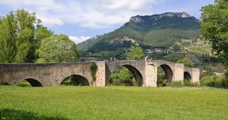
Selon la légende, un agriculteur aurait découvert, au début du 11e siècle, une statue miraculeuse de la Vierge en labourant son champ. Une première église aurait été bâtie à cette époque. Le premier document mentionnant l'église date de 1365. La dévotion à la Vierge attire de nombreux pélerins. Au 14e siècle, des indulgences sont accordées pour la construction d'un pont facilitant l'accès aux pélerins.En 1626, la seconde arcade du côté nord tombe dans la rivière et n'est rétablie qu'en 1633. En 1657, la grande arcade tombe à son tour et est reconstruite deux ans plus tard. Au 18e siècle, le pont étant dégradé, la reconstruction est envisagée mais retardée par plusieurs chutes de l'ouvrage au cours des travaux, emporté par la rivière. L'ouvrage est achevé en 1738. Le pont est formé de six arches, une grande, deux moyennes, deux petites et une plus petite. Les piles intermédiaires sont protégées par des avant-bras bâtis en appareil. La seconde pile, côté rive gauche, portait une petite chapelle.
Map and restricted areas
Open in the main mapRestricted zones
| Zone | Category | Limits | Conditions |
|---|---|---|---|
| Rhone | Zone réglementée | 1529 m above sea level → 6259 m above sea level | Vols interdits sauf lorsque the official document of the zone l'autorise explicitement ou avec l'accord du gestionnaire de la zone lorsqu'il est désigné par the official document of the zone |
| Istres | Zone réglementée | 5491 m above sea level → 30766 m above sea level | Vols interdits sauf lorsque the official document of the zone l'autorise explicitement ou avec l'accord du gestionnaire de la zone lorsqu'il est désigné par the official document of the zone |
| Istres | Zone réglementée | 5491 m above sea level → 30766 m above sea level | Vols interdits sauf lorsque the official document of the zone l'autorise explicitement ou avec l'accord du gestionnaire de la zone lorsqu'il est désigné par the official document of the zone |
Nearby aerodromes
Open aerodromes within 25 km of the spot, heliports included, with their distance and direction from the spot. Near an aerodrome, drone flying is prohibited or height-limited: check the UAS zones map.
| Aerodrome | Type | Distance | Elevation |
|---|---|---|---|
| Florac Ste Enimie Airfield | Aerodrome | 11 km SW | 931 m |
| Mende-Brenoux Airfield | Airport | 14 km N | 1,025 m |
Aviation weather (METAR and TAF)
No METAR station within 50 km.
Weather and Kp index
| Day | Weather | Temp. min. / max. | Wind | Rain | Max Kp |
|---|---|---|---|---|---|
| Tue 17 Nov | Light rain | 9° / 12° | 21 km/h W | 6.4 mm | 5 |
| Wed 18 Nov | Fair | 7° / 12° | 28 km/h W | 4.2 mm | 5 |
| Thu 19 Nov | Showers | 6° / 10° | 30 km/h W | 18 mm | 3 |
| Fri 20 Nov | Light rain | 6° / 8° | 26 km/h W | 6.1 mm | 3 |
| Sat 21 Nov | Partly cloudy | 7° / 12° | 13 km/h W | 0.3 mm | – |
| Sun 22 Nov | Showers | 7° / 9° | 21 km/h W | 8.3 mm | – |
| Mon 23 Nov | Cloudy | 5° / 9° | 14 km/h W | 1.5 mm | – |
Hour by hour: Tuesday 17 November
| Time | Weather | Temp. | Wind | Rain | Clouds | Kp |
|---|---|---|---|---|---|---|
| 15:00 | Light rain | 12° | 18 km/h W | 0.3 mm | 99 % | 4 |
| 16:00 | Light rain | 12° | 16 km/h W | 0.1 mm | 95 % | 4 |
| 17:00 | Rain | 10° | 14 km/h W | 0.8 mm | 100 % | 4 |
| 18:00 | Heavy rain | 10° | 9 km/h W | 1.0 mm | 100 % | 4 |
| 19:00 | Heavy rain | 10° | 13 km/h W | 1.7 mm | 100 % | 5 |
| 20:00 | Heavy rain | 9° | 12 km/h W | 1.1 mm | 100 % | 5 |
| 21:00 | Light rain | 9° | 16 km/h SW | 0.3 mm | 100 % | 5 |
| 22:00 | Rain | 10° | 21 km/h W | 0.6 mm | 100 % | 5 |
Hour by hour: Wednesday 18 November
| Time | Weather | Temp. | Wind | Rain | Clouds | Kp |
|---|---|---|---|---|---|---|
| 06:00 | Light rain | 10° | 24 km/h W | 0.3 mm | 100 % | 4 |
| 07:00 | Light rain | 10° | 23 km/h W | 0.2 mm | 100 % | 4 |
| 08:00 | Light rain | 10° | 26 km/h W | 0.1 mm | 88 % | 4 |
| 09:00 | Showers | 10° | 26 km/h W | 0.1 mm | 74 % | 4 |
| 10:00 | Light rain | 10° | 27 km/h W | 0.2 mm | 99 % | 4 |
| 11:00 | Partly cloudy | 10° | 27 km/h W | – | 66 % | 4 |
| 12:00 | Fair | 11° | 28 km/h W | – | 30 % | 4 |
| 13:00 | Fair | 12° | 26 km/h W | – | 23 % | 3 |
| 14:00 | Partly cloudy | 12° | 27 km/h W | – | 65 % | 3 |
| 15:00 | Showers | 11° | 24 km/h W | 0.1 mm | 62 % | 3 |
| 16:00 | Showers | 10° | 22 km/h W | 0.2 mm | 60 % | 3 |
| 17:00 | Showers | 9° | 20 km/h W | 0.1 mm | 52 % | 3 |
| 18:00 | Partly cloudy | 9° | 18 km/h W | – | 86 % | 3 |
| 19:00 | Fog | 9° | 15 km/h W | – | 100 % | 2 |
| 20:00 | Fog | 9° | 14 km/h W | – | 91 % | 2 |
| 21:00 | Cloudy | 9° | 11 km/h S | – | 91 % | 2 |
| 22:00 | Cloudy | 8° | 7 km/h SE | – | 91 % | 2 |
Sunrise and sunset
| Day | Dawn | Sunrise | Golden hour | Sunset | Dusk | Day length |
|---|---|---|---|---|---|---|
| Tue 17 Nov | 07:13 | 07:44 | 07:44–08:29 · 16:33–17:17 | 17:17 | 17:49 | 9 h 32 |
| Wed 18 Nov | 07:14 | 07:46 | 07:46–08:30 · 16:32–17:16 | 17:16 | 17:48 | 9 h 30 |
| Thu 19 Nov | 07:15 | 07:47 | 07:47–08:32 · 16:31–17:15 | 17:15 | 17:47 | 9 h 28 |
| Fri 20 Nov | 07:17 | 07:48 | 07:48–08:33 · 16:30–17:15 | 17:15 | 17:46 | 9 h 26 |
| Sat 21 Nov | 07:18 | 07:50 | 07:50–08:35 · 16:29–17:14 | 17:14 | 17:46 | 9 h 24 |
| Sun 22 Nov | 07:19 | 07:51 | 07:51–08:36 · 16:28–17:13 | 17:13 | 17:45 | 9 h 22 |
| Mon 23 Nov | 07:20 | 07:52 | 07:52–08:38 · 16:27–17:12 | 17:12 | 17:44 | 9 h 20 |
Reviews (0)
Log in to review this spot. Log in · Create a free account
No reviews yet. Share yours!