

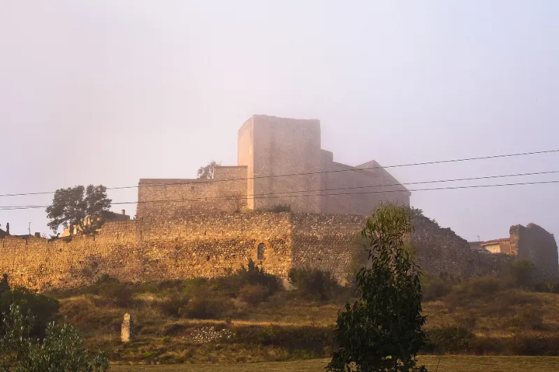
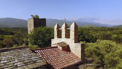
Remains of the Castle and Fortified Enclosure
No reviews yet
Have you flown here? Share your experience with other pilots.
+ Write the first reviewHistory
Le château est mentionné dès 1020. La forteresse de Montalba est intéressante du point de vue de l'art militaire, en ce qu'elle représente ce que serait un château féodal, tel que Pierrepertuse, s'il n'avait été transformé, après Saint-Louis, en forteresse royale. Ici, l'enceinte polygonale n'a été pourvue d'aucun ouvrage de flanquement et, dans le réduit central, les additions résidentielles ont laissé subsister la grosse tour donjon et deux tours rondes. L'enceinte extérieure est constituée de dix-sept sections rectilignes de longueurs inégales. Les murs comportent deux étages d'archères. L'accès aux lices se fait actuellement par rampe carrossable et une brèche pratiquée au nord-ouest. A l'est, un autre cheminement conduit à une porte fortifiée que flanque un beffroi carré. Une chapelle de service, moderne, a été installée dans une partie des bâtiments résidentiels du seigneur, au sud-est du château. A gauche de la chapelle, une tour circulaire dont il ne reste que l'étage de base, supporte un bâtiment ruiné de plan carré. Il est difficile d'évaluer l'ancienneté de la tour carrée dont le couronnement crénelé paraît nettement antérieur au 12e siècle. Contre cette tour, s'appuient sans liaison, au sud, les bâtiments résidentiels beaucoup plus récents, et au nord d'autres constructions de caractère militaire. Les tours rondes ne sont munies que d'archères courtes, à fente large et peu ébrasée, datant apparemment du 12e siècle. L'enceinte extérieure comprend plus de cinquante archères, la plupart étant courtes et contemporaines de la poterne romane du front nord (12e siècle). Un certain nombre d'archères du niveau supérieur des murs sont plus longues et peuvent remonter au milieu du 13e siècle.
Map and restricted areas
Open in the main mapRestricted zones
| Zone | Category | Limits | Conditions |
|---|---|---|---|
| Istres | Zone réglementée | 5491 m above sea level → 30766 m above sea level | Vols interdits sauf lorsque the official document of the zone l'autorise explicitement ou avec l'accord du gestionnaire de la zone lorsqu'il est désigné par the official document of the zone |
Nearby aerodromes
Open aerodromes within 25 km of the spot, heliports included, with their distance and direction from the spot. Near an aerodrome, drone flying is prohibited or height-limited: check the UAS zones map.
| Aerodrome | Type | Distance | Elevation |
|---|---|---|---|
| Base ULM Corneilla de la Rivière | Aerodrome | 14 km E | 70 m |
| Torre-Blanc Llauro | Aerodrome | 21 km SE | 460 m |
Aviation weather (METAR and TAF)
LFMP – Perpignan-Rivesaltes (Llabanère) Airport VFR
METAR
METAR LFMP 171330Z AUTO VRB02KT CAVOK 17/13 Q1006 NOSIG
- Wind
- Variable, 4 km/h
- Visibility
- 10 km or more
- Clouds
- –
- Temperature
- 17 °C, dew point 13 °C
- QNH
- 1006 hPa
- Flight category
- VFR: ceiling > 3,000 ft and visibility > 5 mi
TAF
TAF LFMP 170800Z 1709/1809 VRB02KT 9999 BKN008 BECMG 1710/1712 CAVOK BECMG 1806/1808 28012KT
| Period (local time) | Change | Wind | Visibility | Weather | Clouds |
|---|---|---|---|---|---|
| 17/11 10:00 → 17/11 11:00 | Initial conditions | Variable, 4 km/h | 10 km or more | Broken (5-7/8) at 800 ft (240 m) | |
| 17/11 11:00 → 18/11 07:00 | Becoming | Variable, 4 km/h | 10 km or more | No significant weather | No significant cloud |
| 18/11 07:00 → 18/11 10:00 | Becoming | 280°, 22 km/h | 10 km or more | No significant weather | No significant cloud |
Weather and Kp index
| Day | Weather | Temp. min. / max. | Wind | Rain | Max Kp |
|---|---|---|---|---|---|
| Tue 17 Nov | Light rain | 10° / 15° | 9 km/h W | 0.3 mm | 5 |
| Wed 18 Nov | Partly cloudy | 9° / 17° | 32 km/h NW | 0.2 mm | 5 |
| Thu 19 Nov | Clear sky | 6° / 16° | 39 km/h NW | 1.8 mm | 3 |
| Fri 20 Nov | Partly cloudy | 4° / 16° | 16 km/h W | – | 3 |
| Sat 21 Nov | Cloudy | 5° / 14° | 8 km/h NE | – | – |
| Sun 22 Nov | Clear sky | 8° / 15° | 31 km/h NW | 0.1 mm | – |
| Mon 23 Nov | Partly cloudy | 4° / 13° | 10 km/h W | – | – |
Hour by hour: Tuesday 17 November
| Time | Weather | Temp. | Wind | Rain | Clouds | Kp |
|---|---|---|---|---|---|---|
| 15:00 | Light rain | 15° | 5 km/h SE | 0.2 mm | 100 % | 4 |
| 16:00 | Light rain | 14° | 6 km/h S | 0.1 mm | 100 % | 4 |
| 17:00 | Cloudy | 14° | 4 km/h N | – | 98 % | 4 |
| 18:00 | Cloudy | 12° | 5 km/h NW | – | 98 % | 4 |
| 19:00 | Cloudy | 12° | 9 km/h W | – | 89 % | 5 |
| 20:00 | Cloudy | 11° | 7 km/h W | – | 88 % | 5 |
| 21:00 | Cloudy | 11° | 7 km/h NW | – | 91 % | 5 |
| 22:00 | Partly cloudy | 10° | 6 km/h NW | – | 84 % | 5 |
Hour by hour: Wednesday 18 November
| Time | Weather | Temp. | Wind | Rain | Clouds | Kp |
|---|---|---|---|---|---|---|
| 06:00 | Partly cloudy | 10° | 10 km/h W | – | 71 % | 4 |
| 07:00 | Partly cloudy | 10° | 15 km/h W | – | 56 % | 4 |
| 08:00 | Partly cloudy | 12° | 24 km/h NW | – | 84 % | 4 |
| 09:00 | Partly cloudy | 14° | 29 km/h NW | – | 71 % | 4 |
| 10:00 | Cloudy | 14° | 32 km/h NW | – | 93 % | 4 |
| 11:00 | Partly cloudy | 14° | 29 km/h NW | – | 66 % | 4 |
| 12:00 | Partly cloudy | 16° | 26 km/h NW | – | 77 % | 4 |
| 13:00 | Partly cloudy | 17° | 24 km/h NW | – | 48 % | 3 |
| 14:00 | Partly cloudy | 17° | 21 km/h W | – | 86 % | 3 |
| 15:00 | Light rain | 17° | 14 km/h W | 0.2 mm | 100 % | 3 |
| 16:00 | Cloudy | 15° | 8 km/h S | – | 100 % | 3 |
| 17:00 | Partly cloudy | 14° | 8 km/h S | – | 72 % | 3 |
| 18:00 | Partly cloudy | 12° | 8 km/h SW | – | 80 % | 3 |
| 19:00 | Partly cloudy | 11° | 7 km/h SW | – | 80 % | 2 |
| 20:00 | Partly cloudy | 11° | 6 km/h W | – | 79 % | 2 |
| 21:00 | Partly cloudy | 12° | 7 km/h S | – | 73 % | 2 |
| 22:00 | Partly cloudy | 11° | 7 km/h SE | – | 70 % | 2 |
Sunrise and sunset
| Day | Dawn | Sunrise | Golden hour | Sunset | Dusk | Day length |
|---|---|---|---|---|---|---|
| Tue 17 Nov | 07:13 | 07:44 | 07:44–08:27 · 16:43–17:26 | 17:26 | 17:56 | 9 h 41 |
| Wed 18 Nov | 07:15 | 07:45 | 07:45–08:28 · 16:42–17:25 | 17:25 | 17:55 | 9 h 39 |
| Thu 19 Nov | 07:16 | 07:46 | 07:46–08:29 · 16:41–17:24 | 17:24 | 17:55 | 9 h 37 |
| Fri 20 Nov | 07:17 | 07:48 | 07:48–08:31 · 16:40–17:23 | 17:23 | 17:54 | 9 h 35 |
| Sat 21 Nov | 07:18 | 07:49 | 07:49–08:32 · 16:39–17:22 | 17:22 | 17:53 | 9 h 33 |
| Sun 22 Nov | 07:19 | 07:50 | 07:50–08:33 · 16:38–17:22 | 17:22 | 17:53 | 9 h 31 |
| Mon 23 Nov | 07:20 | 07:51 | 07:51–08:35 · 16:38–17:21 | 17:21 | 17:52 | 9 h 29 |
Reviews (0)
Log in to review this spot. Log in · Create a free account
No reviews yet. Share yours!