

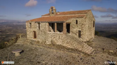
Cuxous Castle
No reviews yet
Have you flown here? Share your experience with other pilots.
+ Write the first reviewHistory
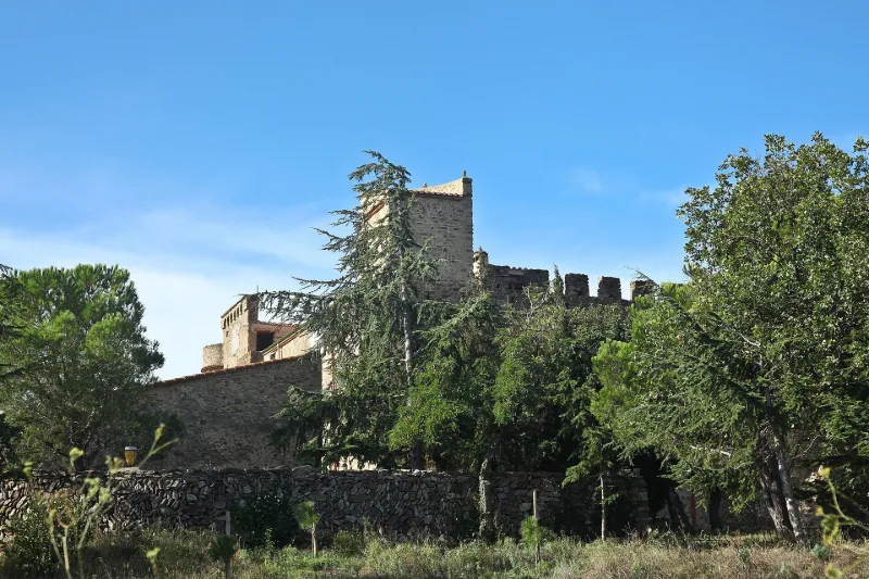
La première mention du lieu apparaît en 1119. L'analyse architecturale du château permet de dater les parties les plus anciennes autour du 11e siècle (opus spicatum sur les murs nord et ouest). L'édifice a fait l'objet de remaniements aux 13e, 18e et début du 20e siècles. Le château est un édifice de plan carré, formé de quatre corps de bâtiment enfermant une cour intérieure. Conçue pour la défense, l'enveloppe du château était à l'origine dépourvue d'ouvertures, toutes les salles prenant jour sur la cour intérieure. Les quatre fronts sont crénelés tandis que deux échauguettes sur encorbellement renforcent la défense sur les angles sud-est et nord-ouest. L'angle nord-est est surmonté d'une tour pigeonnier. Au pied de la façade sud se développe une large terrasse dont le mur de soutènement est un ancien mur de défense édifié pour renforcer le système défensif sur ce front. La présence d'archères permet de le dater de la seconde moitié du 13e siècle. La porte d'accès au fort est surmontée d'une bretèche et ouvre sur un passage couvert qui donne accès à la cour intérieure. Au fond du passage couvert se développe un escalier en vis en demi-hors-oeuvre, muni d'une bouche à feu. La plupart des ouvertures à encadrement rectangulaire semblent appartenir à un aménagement du 19e siècle.
Map and restricted areas
Open in the main mapRestricted zones
| Zone | Category | Limits | Conditions |
|---|---|---|---|
| Istres | Zone réglementée | 5491 m above sea level → 30766 m above sea level | Vols interdits sauf lorsque the official document of the zone l'autorise explicitement ou avec l'accord du gestionnaire de la zone lorsqu'il est désigné par the official document of the zone |
Nearby aerodromes
Open aerodromes within 25 km of the spot, heliports included, with their distance and direction from the spot. Near an aerodrome, drone flying is prohibited or height-limited: check the UAS zones map.
| Aerodrome | Type | Distance | Elevation |
|---|---|---|---|
| Base ULM Corneilla de la Rivière | Aerodrome | 10.0 km SE | 70 m |
| Perpignan-Rivesaltes (Llabanère) Airport | Airport | 19 km E | 44 m |
| Torre-Blanc Llauro | Aerodrome | 23 km S | 460 m |
Aviation weather (METAR and TAF)
LFMP – Perpignan-Rivesaltes (Llabanère) Airport VFR
METAR
METAR LFMP 171330Z AUTO VRB02KT CAVOK 17/13 Q1006 NOSIG
- Wind
- Variable, 4 km/h
- Visibility
- 10 km or more
- Clouds
- –
- Temperature
- 17 °C, dew point 13 °C
- QNH
- 1006 hPa
- Flight category
- VFR: ceiling > 3,000 ft and visibility > 5 mi
TAF
TAF LFMP 170800Z 1709/1809 VRB02KT 9999 BKN008 BECMG 1710/1712 CAVOK BECMG 1806/1808 28012KT
| Period (local time) | Change | Wind | Visibility | Weather | Clouds |
|---|---|---|---|---|---|
| 17/11 10:00 → 17/11 11:00 | Initial conditions | Variable, 4 km/h | 10 km or more | Broken (5-7/8) at 800 ft (240 m) | |
| 17/11 11:00 → 18/11 07:00 | Becoming | Variable, 4 km/h | 10 km or more | No significant weather | No significant cloud |
| 18/11 07:00 → 18/11 10:00 | Becoming | 280°, 22 km/h | 10 km or more | No significant weather | No significant cloud |
Weather and Kp index
| Day | Weather | Temp. min. / max. | Wind | Rain | Max Kp |
|---|---|---|---|---|---|
| Tue 17 Nov | Light rain | 10° / 16° | 9 km/h NW | 0.3 mm | 5 |
| Wed 18 Nov | Fair | 10° / 18° | 32 km/h NW | – | 5 |
| Thu 19 Nov | Clear sky | 8° / 16° | 40 km/h NW | 1.8 mm | 3 |
| Fri 20 Nov | Partly cloudy | 6° / 16° | 19 km/h NW | – | 3 |
| Sat 21 Nov | Cloudy | 7° / 14° | 8 km/h W | – | – |
| Sun 22 Nov | Clear sky | 10° / 15° | 33 km/h NW | 0.2 mm | – |
| Mon 23 Nov | Partly cloudy | 8° / 15° | 15 km/h NW | – | – |
Hour by hour: Tuesday 17 November
| Time | Weather | Temp. | Wind | Rain | Clouds | Kp |
|---|---|---|---|---|---|---|
| 15:00 | Light rain | 16° | 5 km/h S | 0.3 mm | 100 % | 4 |
| 16:00 | Cloudy | 15° | 8 km/h S | – | 100 % | 4 |
| 17:00 | Cloudy | 14° | 4 km/h N | – | 96 % | 4 |
| 18:00 | Cloudy | 13° | 6 km/h NW | – | 95 % | 4 |
| 19:00 | Cloudy | 12° | 9 km/h NW | – | 87 % | 5 |
| 20:00 | Cloudy | 12° | 7 km/h NW | – | 88 % | 5 |
| 21:00 | Partly cloudy | 11° | 7 km/h NW | – | 75 % | 5 |
| 22:00 | Partly cloudy | 10° | 6 km/h NW | – | 77 % | 5 |
Hour by hour: Wednesday 18 November
| Time | Weather | Temp. | Wind | Rain | Clouds | Kp |
|---|---|---|---|---|---|---|
| 06:00 | Cloudy | 11° | 10 km/h NW | – | 98 % | 4 |
| 07:00 | Partly cloudy | 12° | 18 km/h NW | – | 68 % | 4 |
| 08:00 | Cloudy | 13° | 24 km/h NW | – | 98 % | 4 |
| 09:00 | Cloudy | 14° | 29 km/h NW | – | 95 % | 4 |
| 10:00 | Cloudy | 14° | 32 km/h NW | – | 100 % | 4 |
| 11:00 | Partly cloudy | 14° | 29 km/h NW | – | 62 % | 4 |
| 12:00 | Partly cloudy | 16° | 26 km/h NW | – | 44 % | 4 |
| 13:00 | Fair | 17° | 24 km/h NW | – | 28 % | 3 |
| 14:00 | Fair | 18° | 21 km/h NW | – | 34 % | 3 |
| 15:00 | Partly cloudy | 18° | 18 km/h W | – | 59 % | 3 |
| 16:00 | Partly cloudy | 17° | 13 km/h W | – | 86 % | 3 |
| 17:00 | Partly cloudy | 15° | 7 km/h SW | – | 81 % | 3 |
| 18:00 | Partly cloudy | 13° | 5 km/h S | – | 85 % | 3 |
| 19:00 | Partly cloudy | 12° | 4 km/h SW | – | 66 % | 2 |
| 20:00 | Partly cloudy | 12° | 6 km/h SW | – | 60 % | 2 |
| 21:00 | Partly cloudy | 12° | 8 km/h S | – | 70 % | 2 |
| 22:00 | Partly cloudy | 11° | 10 km/h SE | – | 75 % | 2 |
Sunrise and sunset
| Day | Dawn | Sunrise | Golden hour | Sunset | Dusk | Day length |
|---|---|---|---|---|---|---|
| Tue 17 Nov | 07:13 | 07:44 | 07:44–08:26 · 16:42–17:25 | 17:25 | 17:56 | 9 h 41 |
| Wed 18 Nov | 07:14 | 07:45 | 07:45–08:28 · 16:41–17:24 | 17:24 | 17:55 | 9 h 39 |
| Thu 19 Nov | 07:16 | 07:46 | 07:46–08:29 · 16:40–17:24 | 17:24 | 17:54 | 9 h 37 |
| Fri 20 Nov | 07:17 | 07:47 | 07:47–08:31 · 16:40–17:23 | 17:23 | 17:53 | 9 h 35 |
| Sat 21 Nov | 07:18 | 07:49 | 07:49–08:32 · 16:39–17:22 | 17:22 | 17:53 | 9 h 33 |
| Sun 22 Nov | 07:19 | 07:50 | 07:50–08:33 · 16:38–17:21 | 17:21 | 17:52 | 9 h 31 |
| Mon 23 Nov | 07:20 | 07:51 | 07:51–08:35 · 16:37–17:21 | 17:21 | 17:52 | 9 h 29 |
Reviews (0)
Log in to review this spot. Log in · Create a free account
No reviews yet. Share yours!