

Labau Aqueduct Bridge
No reviews yet
Have you flown here? Share your experience with other pilots.
+ Write the first reviewHistory
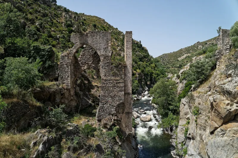
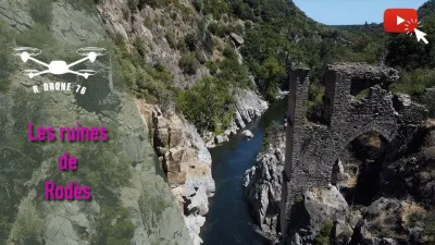
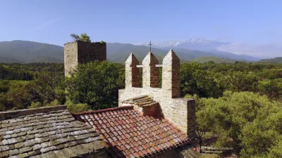
Situé dans la vallée de la Têt, le pont-aqueduc se trouve en limite des communes de Rodès, Bouleternère et Ille-sur-Têt. Mentionné dans des textes datant de 1337 et 1418, il permettait à l'ancien canal royal de Thuir de franchir la Têt. Il subsiste des vestiges de ses piles sur les rives droite et gauche du cours d'eau. La pile toujours visible sur la rive droite comporte une double série d'arches, très élevées, surmontées d'une muraille en opus spitacum. Les claveaux sont de fines lames de schiste et la clef, un bloc de granit. Les piles latérales sont appareillées avec des chaînes d'angle de blocs de marbre rose taillés. La face vers la rivière présente des ressauts destinés à supporter des poutres de bois, la partie du pont enjambant la rivière devant être charpentée. Sur la rive gauche, seul un simple mur est encore visible. Le pont de Labau est remarquable par ses dimensions, son ancienneté, son histoire liée au royaume de Majorque et son appartenance à l'histoire agraire du Roussillon.
Map and restricted areas
Open in the main mapRestricted zones
| Zone | Category | Limits | Conditions |
|---|---|---|---|
| Istres | Zone réglementée | 5491 m above sea level → 30766 m above sea level | Vols interdits sauf lorsque the official document of the zone l'autorise explicitement ou avec l'accord du gestionnaire de la zone lorsqu'il est désigné par the official document of the zone |
Nearby aerodromes
Open aerodromes within 25 km of the spot, heliports included, with their distance and direction from the spot. Near an aerodrome, drone flying is prohibited or height-limited: check the UAS zones map.
| Aerodrome | Type | Distance | Elevation |
|---|---|---|---|
| Base ULM Corneilla de la Rivière | Aerodrome | 14 km E | 70 m |
| Torre-Blanc Llauro | Aerodrome | 18 km SE | 460 m |
Aviation weather (METAR and TAF)
LFMP – Perpignan-Rivesaltes (Llabanère) Airport VFR
METAR
METAR LFMP 171400Z AUTO 12005KT 090V150 CAVOK 16/13 Q1005 NOSIG
- Wind
- 120°, 9 km/h
- Visibility
- 10 km or more
- Clouds
- –
- Temperature
- 16 °C, dew point 13 °C
- QNH
- 1005 hPa
- Flight category
- VFR: ceiling > 3,000 ft and visibility > 5 mi
TAF
TAF LFMP 170800Z 1709/1809 VRB02KT 9999 BKN008 BECMG 1710/1712 CAVOK BECMG 1806/1808 28012KT
| Period (local time) | Change | Wind | Visibility | Weather | Clouds |
|---|---|---|---|---|---|
| 17/11 10:00 → 17/11 11:00 | Initial conditions | Variable, 4 km/h | 10 km or more | Broken (5-7/8) at 800 ft (240 m) | |
| 17/11 11:00 → 18/11 07:00 | Becoming | Variable, 4 km/h | 10 km or more | No significant weather | No significant cloud |
| 18/11 07:00 → 18/11 10:00 | Becoming | 280°, 22 km/h | 10 km or more | No significant weather | No significant cloud |
Weather and Kp index
| Day | Weather | Temp. min. / max. | Wind | Rain | Max Kp |
|---|---|---|---|---|---|
| Tue 17 Nov | Light rain | 11° / 16° | 9 km/h W | 0.3 mm | 5 |
| Wed 18 Nov | Partly cloudy | 10° / 18° | 32 km/h NW | 0.2 mm | 5 |
| Thu 19 Nov | Clear sky | 7° / 17° | 39 km/h NW | 1.8 mm | 3 |
| Fri 20 Nov | Partly cloudy | 5° / 17° | 16 km/h W | – | 3 |
| Sat 21 Nov | Cloudy | 6° / 14° | 8 km/h NE | – | – |
| Sun 22 Nov | Clear sky | 9° / 16° | 31 km/h NW | 0.1 mm | – |
| Mon 23 Nov | Partly cloudy | 5° / 14° | 10 km/h W | – | – |
Hour by hour: Tuesday 17 November
| Time | Weather | Temp. | Wind | Rain | Clouds | Kp |
|---|---|---|---|---|---|---|
| 15:00 | Light rain | 16° | 5 km/h SE | 0.2 mm | 100 % | 4 |
| 16:00 | Light rain | 15° | 6 km/h S | 0.1 mm | 100 % | 4 |
| 17:00 | Cloudy | 14° | 4 km/h N | – | 98 % | 4 |
| 18:00 | Cloudy | 13° | 5 km/h NW | – | 98 % | 4 |
| 19:00 | Cloudy | 12° | 9 km/h W | – | 89 % | 5 |
| 20:00 | Cloudy | 12° | 7 km/h W | – | 88 % | 5 |
| 21:00 | Cloudy | 12° | 7 km/h NW | – | 91 % | 5 |
| 22:00 | Partly cloudy | 11° | 6 km/h NW | – | 84 % | 5 |
Hour by hour: Wednesday 18 November
| Time | Weather | Temp. | Wind | Rain | Clouds | Kp |
|---|---|---|---|---|---|---|
| 06:00 | Partly cloudy | 11° | 10 km/h W | – | 71 % | 4 |
| 07:00 | Partly cloudy | 11° | 15 km/h W | – | 56 % | 4 |
| 08:00 | Partly cloudy | 12° | 24 km/h NW | – | 84 % | 4 |
| 09:00 | Partly cloudy | 14° | 29 km/h NW | – | 71 % | 4 |
| 10:00 | Cloudy | 15° | 32 km/h NW | – | 93 % | 4 |
| 11:00 | Partly cloudy | 15° | 29 km/h NW | – | 66 % | 4 |
| 12:00 | Partly cloudy | 16° | 26 km/h NW | – | 77 % | 4 |
| 13:00 | Partly cloudy | 18° | 24 km/h NW | – | 48 % | 3 |
| 14:00 | Partly cloudy | 18° | 21 km/h W | – | 86 % | 3 |
| 15:00 | Light rain | 18° | 14 km/h W | 0.2 mm | 100 % | 3 |
| 16:00 | Cloudy | 16° | 8 km/h S | – | 100 % | 3 |
| 17:00 | Partly cloudy | 15° | 8 km/h S | – | 72 % | 3 |
| 18:00 | Partly cloudy | 13° | 8 km/h SW | – | 80 % | 3 |
| 19:00 | Partly cloudy | 12° | 7 km/h SW | – | 80 % | 2 |
| 20:00 | Partly cloudy | 12° | 6 km/h W | – | 79 % | 2 |
| 21:00 | Partly cloudy | 12° | 7 km/h S | – | 73 % | 2 |
| 22:00 | Partly cloudy | 12° | 7 km/h SE | – | 70 % | 2 |
Sunrise and sunset
| Day | Dawn | Sunrise | Golden hour | Sunset | Dusk | Day length |
|---|---|---|---|---|---|---|
| Tue 17 Nov | 07:13 | 07:44 | 07:44–08:26 · 16:43–17:26 | 17:26 | 17:56 | 9 h 41 |
| Wed 18 Nov | 07:14 | 07:45 | 07:45–08:28 · 16:42–17:25 | 17:25 | 17:55 | 9 h 39 |
| Thu 19 Nov | 07:16 | 07:46 | 07:46–08:29 · 16:41–17:24 | 17:24 | 17:55 | 9 h 37 |
| Fri 20 Nov | 07:17 | 07:47 | 07:47–08:31 · 16:40–17:23 | 17:23 | 17:54 | 9 h 35 |
| Sat 21 Nov | 07:18 | 07:49 | 07:49–08:32 · 16:39–17:23 | 17:23 | 17:53 | 9 h 33 |
| Sun 22 Nov | 07:19 | 07:50 | 07:50–08:33 · 16:38–17:22 | 17:22 | 17:53 | 9 h 32 |
| Mon 23 Nov | 07:20 | 07:51 | 07:51–08:35 · 16:38–17:21 | 17:21 | 17:52 | 9 h 30 |
Reviews (0)
Log in to review this spot. Log in · Create a free account
No reviews yet. Share yours!