

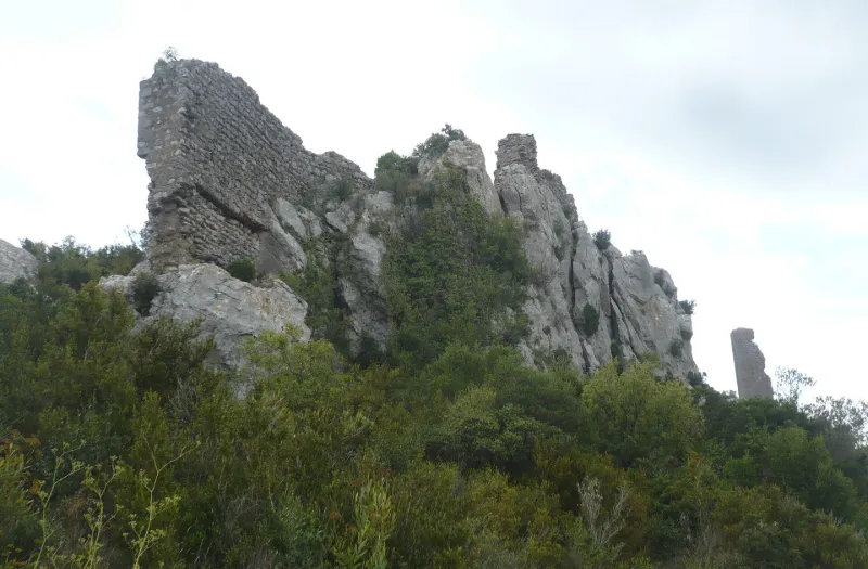
Surviving Parts of the Castle
No reviews yet
Have you flown here? Share your experience with other pilots.
+ Write the first reviewHistory
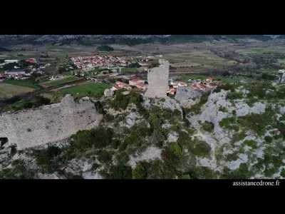
La première mention du château remonte à 1012. Partiellement détruit en 1474 pendant l'occupation de la province par Louis XI, l'édifice fut définitivement démantelé à l'explosif après le traité des Pyrénées (1659). Le château était naturellement défendu sur son flanc ouest par une paroi verticale. A l'est, la pente étant plus douce, l'aménagement d'un système défensif s'imposait. Il n'en reste plus que quelques bases de murs et la base d'une tour cylindrique. Le château proprement dit est séparé du premier ensemble défensif par un fossé en partie naturel, en partie taillé, conférant au château la position d'un édifice sur éperon barré.
Map and restricted areas
Open in the main mapRestricted zones
| Zone | Category | Limits | Conditions |
|---|---|---|---|
| Ctr Perpignan |
Zone de contrôle civile | 50 m above ground level → 305 m above ground level · 50 m above ground level → 610 m above sea level | Flights above 50 metres are forbidden without the prior agreement of air traffic control |
| Istres | Zone réglementée | 5491 m above sea level → 30766 m above sea level | Vols interdits sauf lorsque the official document of the zone l'autorise explicitement ou avec l'accord du gestionnaire de la zone lorsqu'il est désigné par the official document of the zone |
Nearby aerodromes
Open aerodromes within 25 km of the spot, heliports included, with their distance and direction from the spot. Near an aerodrome, drone flying is prohibited or height-limited: check the UAS zones map.
| Aerodrome | Type | Distance | Elevation |
|---|---|---|---|
| Perpignan-Rivesaltes (Llabanère) Airport | Airport | 13 km SE | 44 m |
| Base ULM Corneilla de la Rivière | Aerodrome | 13 km S | 70 m |
| Base Hydro-ULM La Salanque Latécoère | Seaplane base | 21 km E | 0 m |
| St Laurent de la Salanque Airbase | Aerodrome | 21 km E | 9 m |
Aviation weather (METAR and TAF)
LFMP – Perpignan-Rivesaltes (Llabanère) Airport VFR
METAR
METAR LFMP 171330Z AUTO VRB02KT CAVOK 17/13 Q1006 NOSIG
- Wind
- Variable, 4 km/h
- Visibility
- 10 km or more
- Clouds
- –
- Temperature
- 17 °C, dew point 13 °C
- QNH
- 1006 hPa
- Flight category
- VFR: ceiling > 3,000 ft and visibility > 5 mi
TAF
TAF LFMP 170800Z 1709/1809 VRB02KT 9999 BKN008 BECMG 1710/1712 CAVOK BECMG 1806/1808 28012KT
| Period (local time) | Change | Wind | Visibility | Weather | Clouds |
|---|---|---|---|---|---|
| 17/11 10:00 → 17/11 11:00 | Initial conditions | Variable, 4 km/h | 10 km or more | Broken (5-7/8) at 800 ft (240 m) | |
| 17/11 11:00 → 18/11 07:00 | Becoming | Variable, 4 km/h | 10 km or more | No significant weather | No significant cloud |
| 18/11 07:00 → 18/11 10:00 | Becoming | 280°, 22 km/h | 10 km or more | No significant weather | No significant cloud |
Weather and Kp index
| Day | Weather | Temp. min. / max. | Wind | Rain | Max Kp |
|---|---|---|---|---|---|
| Tue 17 Nov | Light rain | 10° / 15° | 10 km/h NW | 0.3 mm | 5 |
| Wed 18 Nov | Fair | 10° / 18° | 32 km/h NW | – | 5 |
| Thu 19 Nov | Clear sky | 8° / 16° | 40 km/h NW | 1.2 mm | 3 |
| Fri 20 Nov | Partly cloudy | 6° / 17° | 18 km/h NW | – | 3 |
| Sat 21 Nov | Cloudy | 7° / 15° | 8 km/h NW | – | – |
| Sun 22 Nov | Fair | 9° / 15° | 33 km/h NW | 0.1 mm | – |
| Mon 23 Nov | Cloudy | 9° / 15° | 15 km/h NW | 0.1 mm | – |
Hour by hour: Tuesday 17 November
| Time | Weather | Temp. | Wind | Rain | Clouds | Kp |
|---|---|---|---|---|---|---|
| 15:00 | Light rain | 15° | 5 km/h SE | 0.3 mm | 100 % | 4 |
| 16:00 | Cloudy | 15° | 8 km/h S | – | 100 % | 4 |
| 17:00 | Cloudy | 14° | 5 km/h N | – | 97 % | 4 |
| 18:00 | Cloudy | 13° | 8 km/h N | – | 98 % | 4 |
| 19:00 | Cloudy | 12° | 10 km/h NW | – | 87 % | 5 |
| 20:00 | Cloudy | 12° | 7 km/h NW | – | 88 % | 5 |
| 21:00 | Partly cloudy | 11° | 7 km/h NW | – | 84 % | 5 |
| 22:00 | Cloudy | 10° | 7 km/h NW | – | 90 % | 5 |
Hour by hour: Wednesday 18 November
| Time | Weather | Temp. | Wind | Rain | Clouds | Kp |
|---|---|---|---|---|---|---|
| 06:00 | Cloudy | 10° | 8 km/h NW | – | 98 % | 4 |
| 07:00 | Partly cloudy | 11° | 15 km/h NW | – | 70 % | 4 |
| 08:00 | Cloudy | 13° | 23 km/h NW | – | 98 % | 4 |
| 09:00 | Cloudy | 14° | 29 km/h NW | – | 94 % | 4 |
| 10:00 | Cloudy | 14° | 32 km/h NW | – | 99 % | 4 |
| 11:00 | Partly cloudy | 14° | 31 km/h NW | – | 52 % | 4 |
| 12:00 | Partly cloudy | 16° | 26 km/h NW | – | 46 % | 4 |
| 13:00 | Fair | 17° | 24 km/h NW | – | 21 % | 3 |
| 14:00 | Fair | 18° | 21 km/h NW | – | 27 % | 3 |
| 15:00 | Partly cloudy | 18° | 17 km/h W | – | 45 % | 3 |
| 16:00 | Cloudy | 17° | 12 km/h W | – | 89 % | 3 |
| 17:00 | Partly cloudy | 15° | 9 km/h SW | – | 81 % | 3 |
| 18:00 | Partly cloudy | 14° | 6 km/h S | – | 84 % | 3 |
| 19:00 | Partly cloudy | 13° | 5 km/h SW | – | 69 % | 2 |
| 20:00 | Partly cloudy | 12° | 6 km/h SW | – | 62 % | 2 |
| 21:00 | Partly cloudy | 12° | 9 km/h SE | – | 71 % | 2 |
| 22:00 | Partly cloudy | 12° | 11 km/h SE | – | 61 % | 2 |
Sunrise and sunset
| Day | Dawn | Sunrise | Golden hour | Sunset | Dusk | Day length |
|---|---|---|---|---|---|---|
| Tue 17 Nov | 07:13 | 07:43 | 07:43–08:26 · 16:42–17:25 | 17:25 | 17:55 | 9 h 41 |
| Wed 18 Nov | 07:14 | 07:45 | 07:45–08:28 · 16:41–17:24 | 17:24 | 17:54 | 9 h 39 |
| Thu 19 Nov | 07:15 | 07:46 | 07:46–08:29 · 16:40–17:23 | 17:23 | 17:54 | 9 h 37 |
| Fri 20 Nov | 07:16 | 07:47 | 07:47–08:30 · 16:39–17:22 | 17:22 | 17:53 | 9 h 35 |
| Sat 21 Nov | 07:18 | 07:48 | 07:48–08:32 · 16:38–17:21 | 17:21 | 17:52 | 9 h 33 |
| Sun 22 Nov | 07:19 | 07:50 | 07:50–08:33 · 16:37–17:21 | 17:21 | 17:52 | 9 h 31 |
| Mon 23 Nov | 07:20 | 07:51 | 07:51–08:34 · 16:36–17:20 | 17:20 | 17:51 | 9 h 29 |


Reviews (0)
Log in to review this spot. Log in · Create a free account
No reviews yet. Share yours!