

Notre-Dame-de-Mayran Chapel
No reviews yet
Have you flown here? Share your experience with other pilots.
+ Write the first reviewHistory
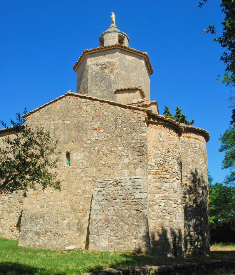
11e siècle ; 12e siècle L'église semble avoir été édifiée sur un ancien lieu de culte gallo-romain (monnaies des 3e et 4e siècles retrouvées). Elle se trouve sur l'ancienne voie romaine reliant Saint-Paul - Saint-Martin et aboutissant au carrefour de Saussine où s'élève un monument romain. Une stèle funéraire romaine dédiée aux dieux manes se trouve remployée dans un pilier de l'église. L'édifice a été bâti à la fin du 11e ou au début du 12e siècle et fut prieuré jusqu'au début du 18e siècle. Quelques ermites s'y succédèrent jusqu'à la fin du 19e siècle. La chapelle est à nef unique avec abside semi-circulaire flanquée d'absidioles qui s'ouvrent sur un transept. A la croisée du transept s'élève une coupole sur trompes. La nef est couverte d'une fausse voûte en berceau plein cintre établie au 19e siècle sous la charpente. A l'extérieur, un lanternon cylindrique se dresse sur la tour octogonale au-dessus du transept. Au nord, des bâtiments domestiques ont été adossés à la nef de l'église. Il s'agit de constructions du 17e et 18e siècle.
Map and restricted areas
Open in the main mapRestricted zones
Nearby aerodromes
Open aerodromes within 25 km of the spot, heliports included, with their distance and direction from the spot. Near an aerodrome, drone flying is prohibited or height-limited: check the UAS zones map.
| Aerodrome | Type | Distance | Elevation |
|---|---|---|---|
| Aérodrome d'Avignon-Pujaut | Aerodrome | 11 km SE | 45 m |
| Orange-Caritat (BA 115) Air Base | Airport | 17 km NE | 60 m |
| Centre Hospitalier Heliport | Heliport | 20 km SE | 21 m |
| Uzès Airfield | Aerodrome | 22 km W | 270 m |
| Aérodrome du Plan-de-Dieu - Orange | Aerodrome | 23 km NE | 93 m |
Aviation weather (METAR and TAF)
LFMO – Orange-Caritat (BA 115) Air Base VFR
METAR
METAR LFMO 171400Z AUTO VRB01KT 9999 ///TCU 13/11 Q1004 BECMG BKN080
- Wind
- Variable, 2 km/h
- Visibility
- 10 km or more
- Clouds
- –
- Temperature
- 13 °C, dew point 11 °C
- QNH
- 1004 hPa
- Flight category
- VFR: ceiling > 3,000 ft and visibility > 5 mi
TAF
TAF LFMO 171400Z 1715/1815 13008KT CAVOK TX16/1814Z TN11/1804Z TEMPO 1717/1802 BKN010 PROB40 TEMPO 1717/1723 3000 BR BKN005 TEMPO 1804/1809 3000 BR PROB30 1805/1808 0800 FG BKN002
| Period (local time) | Change | Wind | Visibility | Weather | Clouds |
|---|---|---|---|---|---|
| 17/11 16:00 → 18/11 16:00 | Initial conditions | 130°, 15 km/h | 10 km or more | No significant cloud | |
| 17/11 18:00 → 18/11 03:00 | Temporarily | Broken (5-7/8) at 1,000 ft (300 m) | |||
| 17/11 18:00 → 18/11 00:00 | Temporarily, probability 40% | 3.0 km | Mist | Broken (5-7/8) at 500 ft (150 m) | |
| 18/11 05:00 → 18/11 10:00 | Temporarily | 3.0 km | Mist | ||
| 18/11 06:00 → 18/11 09:00 | probability 30% | 800 m | Fog | Broken (5-7/8) at 200 ft (60 m) |
Weather and Kp index
Sunrise and sunset
| Day | Dawn | Sunrise | Golden hour | Sunset | Dusk | Day length |
|---|---|---|---|---|---|---|
| Tue 17 Nov | 07:08 | 07:39 | 07:39–08:23 · 16:29–17:13 | 17:13 | 17:45 | 9 h 34 |
| Wed 18 Nov | 07:09 | 07:40 | 07:40–08:25 · 16:28–17:13 | 17:13 | 17:44 | 9 h 32 |
| Thu 19 Nov | 07:10 | 07:42 | 07:42–08:26 · 16:27–17:12 | 17:12 | 17:43 | 9 h 30 |
| Fri 20 Nov | 07:11 | 07:43 | 07:43–08:27 · 16:26–17:11 | 17:11 | 17:42 | 9 h 28 |
| Sat 21 Nov | 07:13 | 07:44 | 07:44–08:29 · 16:25–17:10 | 17:10 | 17:42 | 9 h 25 |
| Sun 22 Nov | 07:14 | 07:45 | 07:45–08:30 · 16:25–17:09 | 17:09 | 17:41 | 9 h 23 |
| Mon 23 Nov | 07:15 | 07:47 | 07:47–08:32 · 16:24–17:09 | 17:09 | 17:40 | 9 h 22 |


Reviews (0)
Log in to review this spot. Log in · Create a free account
No reviews yet. Share yours!