

Saint Lawrence Chapel
No reviews yet
Have you flown here? Share your experience with other pilots.
+ Write the first reviewHistory
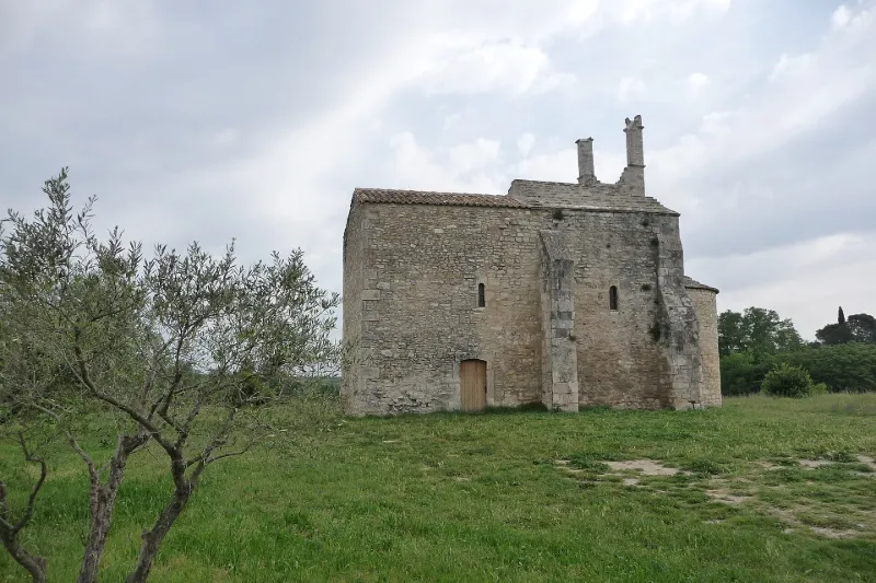
12e siècle Petit édifice roman comportant une nef de deux travées avec une abside demi-circulaire. L'entrée de cette dernière est caractérisée par deux grosses colonnes engagées, couronnées de chapiteaux très frustes. La première travée de la nef, près de l'abside, est voûtée en berceau. L'autre travée a perdu sa voûte. Un fort doubleau recoupait la voûte, porté sur des piles qui reçoivent en même temps des arcs latéraux. La façade Est s'élève en pignon au-dessus de l'abside et est décorée de trois arcatures plein cintre. Une corniche moulurée couronnait les rampants et un campanile sur plan carré surmontait le tout. La couverture d'origine était en lauzes calcaires. Ce petit monument est l'un des rares vestiges du 12e siècle de ce genre, subsistant dans le Gard.
Map and restricted areas
Open in the main mapRestricted zones
| Zone | Category | Limits | Conditions |
|---|---|---|---|
| Ctr Garons |
Zone de contrôle civile | 50 m above ground level → 762 m above sea level | Flights above 50 metres are forbidden without the prior agreement of air traffic control |
| Rhone | Zone réglementée | 762 m above sea level → 6259 m above sea level | Vols interdits sauf lorsque the official document of the zone l'autorise explicitement ou avec l'accord du gestionnaire de la zone lorsqu'il est désigné par the official document of the zone |
| Istres | Zone réglementée | 5491 m above sea level → 30766 m above sea level | Vols interdits sauf lorsque the official document of the zone l'autorise explicitement ou avec l'accord du gestionnaire de la zone lorsqu'il est désigné par the official document of the zone |
| Istres | Zone réglementée | 5491 m above sea level → 30766 m above sea level | Vols interdits sauf lorsque the official document of the zone l'autorise explicitement ou avec l'accord du gestionnaire de la zone lorsqu'il est désigné par the official document of the zone |
| Zrt 108 E4 | ZRT | From about 2,300 m to about 4,400 m above sea level | SUP AIP 232/24 · Du 6 janvier 2025 au 14 avril 2027 |
Nearby aerodromes
Open aerodromes within 25 km of the spot, heliports included, with their distance and direction from the spot. Near an aerodrome, drone flying is prohibited or height-limited: check the UAS zones map.
| Aerodrome | Type | Distance | Elevation |
|---|---|---|---|
| Nîmes Courbessac Airport | Aerodrome | 13 km W | 60 m |
| Nîmes-Arles-Camargue Airport | Airport | 15 km SW | 94 m |
| Centre Hospitalier Heliport | Heliport | 20 km NE | 21 m |
| Aérodrome d'Avignon-Pujaut | Aerodrome | 23 km NE | 45 m |
Aviation weather (METAR and TAF)
LFTW – Nîmes-Arles-Camargue Airport VFR
METAR
METAR LFTW 171400Z AUTO 01003KT 340V050 9999 FEW064/// SCT120/// OVC150/// ///TCU 14/12 Q1004 TEMPO 4000 SHRA
- Wind
- 010°, 6 km/h
- Visibility
- 10 km or more
- Clouds
- Few (1-2/8) at 6,400 ft (1950 m) ; Scattered (3-4/8) at 12,000 ft (3660 m) ; Overcast (8/8) at 15,000 ft (4570 m)
- Temperature
- 14 °C, dew point 12 °C
- QNH
- 1004 hPa
- Flight category
- VFR: ceiling > 3,000 ft and visibility > 5 mi
TAF
TAF LFTW 170800Z 1709/1809 03005KT 9999 SCT013 PROB40 TEMPO 1709/1719 BKN006 PROB40 TEMPO 1711/1717 4000 SHRA SCT070TCU BECMG 1716/1718 23010KT
| Period (local time) | Change | Wind | Visibility | Weather | Clouds |
|---|---|---|---|---|---|
| 17/11 10:00 → 17/11 17:00 | Initial conditions | 030°, 9 km/h | 10 km or more | Scattered (3-4/8) at 1,300 ft (400 m) | |
| 17/11 10:00 → 17/11 20:00 | Temporarily, probability 40% | Broken (5-7/8) at 600 ft (180 m) | |||
| 17/11 12:00 → 17/11 18:00 | Temporarily, probability 40% | 4.0 km | Showers of rain | Scattered (3-4/8) at 7,000 ft (2130 m) (towering cumulus) | |
| 17/11 17:00 → 18/11 10:00 | Becoming | 230°, 19 km/h | 10 km or more | Scattered (3-4/8) at 1,300 ft (400 m) |
Weather and Kp index
Sunrise and sunset
| Day | Dawn | Sunrise | Golden hour | Sunset | Dusk | Day length |
|---|---|---|---|---|---|---|
| Tue 17 Nov | 07:08 | 07:39 | 07:39–08:23 · 16:31–17:15 | 17:15 | 17:46 | 9 h 35 |
| Wed 18 Nov | 07:09 | 07:40 | 07:40–08:24 · 16:30–17:14 | 17:14 | 17:45 | 9 h 33 |
| Thu 19 Nov | 07:10 | 07:41 | 07:41–08:26 · 16:29–17:13 | 17:13 | 17:44 | 9 h 31 |
| Fri 20 Nov | 07:11 | 07:43 | 07:43–08:27 · 16:28–17:12 | 17:12 | 17:43 | 9 h 29 |
| Sat 21 Nov | 07:12 | 07:44 | 07:44–08:28 · 16:27–17:11 | 17:11 | 17:43 | 9 h 27 |
| Sun 22 Nov | 07:14 | 07:45 | 07:45–08:30 · 16:26–17:10 | 17:10 | 17:42 | 9 h 25 |
| Mon 23 Nov | 07:15 | 07:46 | 07:46–08:31 · 16:25–17:10 | 17:10 | 17:41 | 9 h 23 |


Reviews (0)
Log in to review this spot. Log in · Create a free account
No reviews yet. Share yours!