

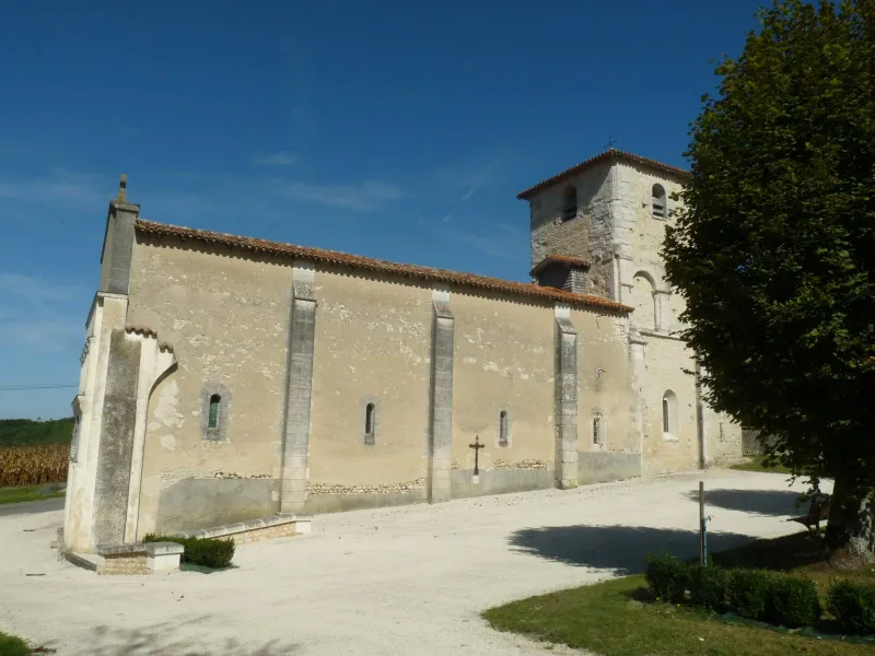
Saint-Félix Church
No reviews yet
Have you flown here? Share your experience with other pilots.
+ Write the first reviewHistory
12e siècle L'église appartenait autrefois à l'ancien diocèse de Saintes et eut à souffrir de la guerre de Cent ans. L'édifice est à vaisseau unique se terminant, vers l'est, par une abside semi-circulaire. La façade occidentale est typiquement charentaise. Elle comprend un rez-de-chaussée à trois arcs en plein cintre, bordé d'un cordon ouvragé. Au-dessus, séparé par une corniche, s'élève un étage d'arcatures portées par des colonnes à chapiteaux ouvragés et séparées par des pilastres. A l'intérieur, la nef, restaurée au 19e siècle, conserve les traces des grandes arcatures plein cintre qui devaient décorer les murs gouttereaux. Le faux carré, plus étroit et couvert d'une coupole sur pendentifs, est orné, sur ses faces latérales, d'arcs reposant sur des pilastres et des colonnes rondes adossées à chapiteaux romans historiés. L'abside est voûtée en cul de four. Le clocher carré à deux étages est percé d'arcatures en plein cintre. Son second niveau a été reconstruit en 1888.
Map and restricted areas
Open in the main mapRestricted zones
| Zone | Category | Limits | Conditions |
|---|---|---|---|
| Zrt Alienor Charlie | ZRT | From the ground up to about 240 m above the ground | SUP AIP 223/26 · Du lundi 26 octobre au mercredi 28 octobre 2026 |
Nearby aerodromes
Open aerodromes within 25 km of the spot, heliports included, with their distance and direction from the spot. Near an aerodrome, drone flying is prohibited or height-limited: check the UAS zones map.
| Aerodrome | Type | Distance | Elevation |
|---|---|---|---|
| Chalais Airfield | Aerodrome | 12 km S | 87 m |
Aviation weather (METAR and TAF)
LFBG – Cognac-Châteaubernard (BA 709) Air Base MVFR
METAR
METAR LFBG 171400Z AUTO 22016KT 9999 BKN023 BKN031 BKN082 18/13 Q1000 TEMPO 4000 SHRA SCT030TCU BECMG 25018G28KT
- Wind
- 220°, 30 km/h
- Visibility
- 10 km or more
- Clouds
- Broken (5-7/8) at 2,300 ft (700 m) ; Broken (5-7/8) at 3,100 ft (940 m) ; Broken (5-7/8) at 8,200 ft (2500 m)
- Temperature
- 18 °C, dew point 13 °C
- QNH
- 1000 hPa
- Flight category
- MVFR: ceiling 1,000–3,000 ft or visibility 3–5 mi
TAF
TAF LFBG 170800Z 1709/1809 25018G28KT 9999 BKN020 PROB30 TEMPO 1715/1718 4000 SHRA SCT030TCU TEMPO 1719/1723 24025G35KT 4000 SHRA BKN030TCU PROB40 TEMPO 1720/1722 3000 TSRA BKN025CB TEMPO 1806/1809 4000 SHRA BKN020TCU
| Period (local time) | Change | Wind | Visibility | Weather | Clouds |
|---|---|---|---|---|---|
| 17/11 10:00 → 18/11 10:00 | Initial conditions | 250°, 33 km/h, gusts 52 km/h | 10 km or more | Broken (5-7/8) at 2,000 ft (610 m) | |
| 17/11 16:00 → 17/11 19:00 | Temporarily, probability 30% | 4.0 km | Showers of rain | Scattered (3-4/8) at 3,000 ft (910 m) (towering cumulus) | |
| 17/11 20:00 → 18/11 00:00 | Temporarily | 240°, 46 km/h, gusts 65 km/h | 4.0 km | Showers of rain | Broken (5-7/8) at 3,000 ft (910 m) (towering cumulus) |
| 17/11 21:00 → 17/11 23:00 | Temporarily, probability 40% | 3.0 km | Thunderstorm rain | Broken (5-7/8) at 2,500 ft (760 m) (cumulonimbus) | |
| 18/11 07:00 → 18/11 10:00 | Temporarily | 4.0 km | Showers of rain | Broken (5-7/8) at 2,000 ft (610 m) (towering cumulus) |
Weather and Kp index
Sunrise and sunset
| Day | Dawn | Sunrise | Golden hour | Sunset | Dusk | Day length |
|---|---|---|---|---|---|---|
| Tue 17 Nov | 07:29 | 08:01 | 08:01–08:47 · 16:43–17:28 | 17:28 | 18:01 | 9 h 27 |
| Wed 18 Nov | 07:31 | 08:03 | 08:03–08:48 · 16:42–17:28 | 17:28 | 18:00 | 9 h 24 |
| Thu 19 Nov | 07:32 | 08:04 | 08:04–08:50 · 16:41–17:27 | 17:27 | 17:59 | 9 h 22 |
| Fri 20 Nov | 07:33 | 08:05 | 08:05–08:51 · 16:40–17:26 | 17:26 | 17:58 | 9 h 20 |
| Sat 21 Nov | 07:34 | 08:07 | 08:07–08:53 · 16:39–17:25 | 17:25 | 17:57 | 9 h 18 |
| Sun 22 Nov | 07:36 | 08:08 | 08:08–08:54 · 16:38–17:24 | 17:24 | 17:57 | 9 h 16 |
| Mon 23 Nov | 07:37 | 08:09 | 08:09–08:56 · 16:37–17:23 | 17:23 | 17:56 | 9 h 14 |


Reviews (0)
Log in to review this spot. Log in · Create a free account
No reviews yet. Share yours!