

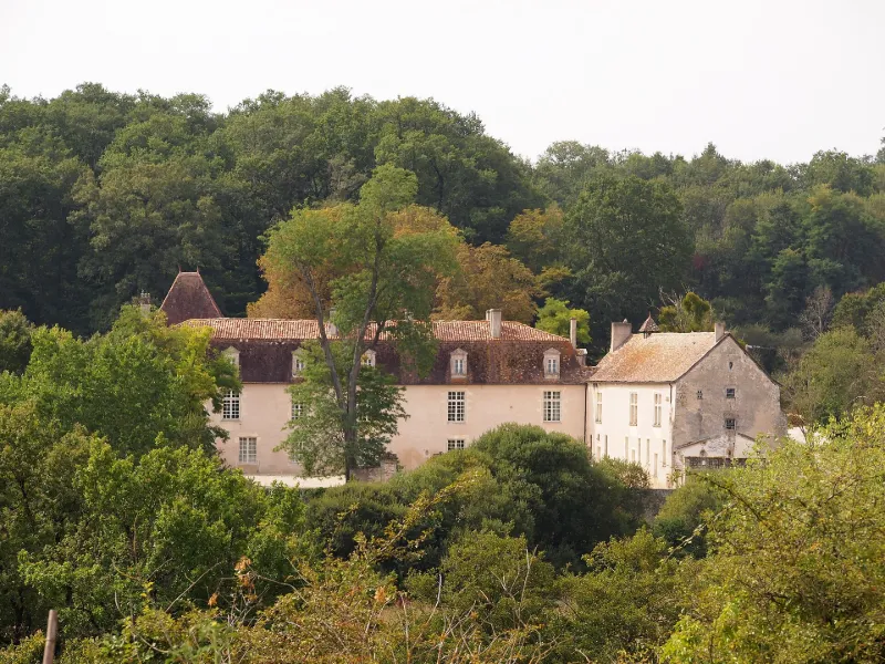
La Faye Castle
No reviews yet
Have you flown here? Share your experience with other pilots.
+ Write the first reviewHistory
16e siècle ; 18e siècle La Faye remonte au 13e siècle. C'était le siège d'une importante seigneurie. Louis Gabriel s'installe au château et doit être l'auteur des transformations du logis médiéval en demeure plus commode. La famille partira à la Révolution. Au 19e siècle, la chapelle fut détruite, le bâtiment principal nettoyé de divers bâtiments annexes et entouré d'un jardin, des meneaux furent rajoutés aux fenêtres, les intérieurs réaménagés. Une allée de marronniers, deux bâtiments de communs, une ferme conduisent au château bâti sur un terre-plein entouré de douves autrefois alimentées par trois étangs. Un pont enjambe le fossé au nord. Deux corps de logis en angle droit forment le château. L'aile nord-sud est de caractère médiéval (15e siècle) dans sa structure et ses détails de construction (pignons, fenêtres à meneaux...). Elle abrite des anciennes cuisines, granges, ateliers, greniers. L'aile est-ouest sous toiture à pans brisés est cantonnée d'une tour carrée orientale et d'une petite avancée à l'ouest. Elle comprend les pièces d'habitation.
Map and restricted areas
Open in the main mapRestricted zones
| Zone | Category | Limits | Conditions |
|---|---|---|---|
| Zrt Alienor Bravo | ZRT | From the ground up to about 240 m above the ground | SUP AIP 223/26 · Du lundi 26 octobre au mercredi 28 octobre 2026 |
Nearby aerodromes
Open aerodromes within 25 km of the spot, heliports included, with their distance and direction from the spot. Near an aerodrome, drone flying is prohibited or height-limited: check the UAS zones map.
| Aerodrome | Type | Distance | Elevation |
|---|---|---|---|
| Chalais Airfield | Aerodrome | 16 km S | 87 m |
Aviation weather (METAR and TAF)
LFBG – Cognac-Châteaubernard (BA 709) Air Base VFR
METAR
METAR LFBG 171330Z AUTO 23016KT 9999 SCT025 BKN031 BKN038 18/13 Q1000 TEMPO 4000 SHRA SCT030TCU BECMG 25018G28KT
- Wind
- 230°, 30 km/h
- Visibility
- 10 km or more
- Clouds
- Scattered (3-4/8) at 2,500 ft (760 m) ; Broken (5-7/8) at 3,100 ft (940 m) ; Broken (5-7/8) at 3,800 ft (1160 m)
- Temperature
- 18 °C, dew point 13 °C
- QNH
- 1000 hPa
- Flight category
- VFR: ceiling > 3,000 ft and visibility > 5 mi
TAF
TAF LFBG 170800Z 1709/1809 25018G28KT 9999 BKN020 PROB30 TEMPO 1715/1718 4000 SHRA SCT030TCU TEMPO 1719/1723 24025G35KT 4000 SHRA BKN030TCU PROB40 TEMPO 1720/1722 3000 TSRA BKN025CB TEMPO 1806/1809 4000 SHRA BKN020TCU
| Period (local time) | Change | Wind | Visibility | Weather | Clouds |
|---|---|---|---|---|---|
| 17/11 10:00 → 18/11 10:00 | Initial conditions | 250°, 33 km/h, gusts 52 km/h | 10 km or more | Broken (5-7/8) at 2,000 ft (610 m) | |
| 17/11 16:00 → 17/11 19:00 | Temporarily, probability 30% | 4.0 km | Showers of rain | Scattered (3-4/8) at 3,000 ft (910 m) (towering cumulus) | |
| 17/11 20:00 → 18/11 00:00 | Temporarily | 240°, 46 km/h, gusts 65 km/h | 4.0 km | Showers of rain | Broken (5-7/8) at 3,000 ft (910 m) (towering cumulus) |
| 17/11 21:00 → 17/11 23:00 | Temporarily, probability 40% | 3.0 km | Thunderstorm rain | Broken (5-7/8) at 2,500 ft (760 m) (cumulonimbus) | |
| 18/11 07:00 → 18/11 10:00 | Temporarily | 4.0 km | Showers of rain | Broken (5-7/8) at 2,000 ft (610 m) (towering cumulus) |
Weather and Kp index
| Day | Weather | Temp. min. / max. | Wind | Rain | Max Kp |
|---|---|---|---|---|---|
| Tue 17 Nov | Showers | 14° / 17° | 30 km/h SW | 8.3 mm | 5 |
| Wed 18 Nov | Heavy rain | 11° / 14° | 30 km/h SW | 15 mm | 5 |
| Thu 19 Nov | Heavy rain | 9° / 12° | 32 km/h W | 17 mm | 3 |
| Fri 20 Nov | Rain | 9° / 13° | 21 km/h SW | 7.4 mm | 3 |
| Sat 21 Nov | Cloudy | 8° / 13° | 17 km/h SE | 4.2 mm | – |
| Sun 22 Nov | Showers | 11° / 14° | 23 km/h W | 5.6 mm | – |
| Mon 23 Nov | Cloudy | 8° / 14° | 11 km/h SW | 0.2 mm | – |
Hour by hour: Tuesday 17 November
| Time | Weather | Temp. | Wind | Rain | Clouds | Kp |
|---|---|---|---|---|---|---|
| 15:00 | Showers | 17° | 28 km/h SW | 0.1 mm | 85 % | 4 |
| 16:00 | Rain | 16° | 26 km/h SW | 0.4 mm | 94 % | 4 |
| 17:00 | Light rain | 14° | 24 km/h SW | 0.2 mm | 94 % | 4 |
| 18:00 | Partly cloudy | 14° | 27 km/h SW | – | 86 % | 4 |
| 19:00 | Rain | 14° | 30 km/h SW | 0.5 mm | 98 % | 5 |
| 20:00 | Light rain | 14° | 29 km/h SW | 0.2 mm | 100 % | 5 |
| 21:00 | Rain | 14° | 30 km/h SW | 0.9 mm | 98 % | 5 |
| 22:00 | Heavy rain | 14° | 27 km/h SW | 2.0 mm | 100 % | 5 |
Hour by hour: Wednesday 18 November
| Time | Weather | Temp. | Wind | Rain | Clouds | Kp |
|---|---|---|---|---|---|---|
| 06:00 | Partly cloudy | 12° | 22 km/h W | – | 52 % | 4 |
| 07:00 | Fair | 12° | 22 km/h SW | – | 31 % | 4 |
| 08:00 | Showers | 11° | 21 km/h SW | 0.4 mm | 43 % | 4 |
| 09:00 | Showers | 11° | 21 km/h SW | 0.1 mm | 51 % | 4 |
| 10:00 | Showers | 12° | 21 km/h SW | 0.2 mm | 66 % | 4 |
| 11:00 | Showers | 13° | 21 km/h SW | 0.3 mm | 70 % | 4 |
| 12:00 | Showers | 14° | 22 km/h SW | 2.4 mm | 81 % | 4 |
| 13:00 | Heavy rain | 13° | 23 km/h SW | 1.2 mm | 88 % | 3 |
| 14:00 | Light rain | 13° | 24 km/h SW | 0.1 mm | 98 % | 3 |
| 15:00 | Cloudy | 13° | 23 km/h SW | – | 94 % | 3 |
| 16:00 | Partly cloudy | 14° | 17 km/h SW | – | 68 % | 3 |
| 17:00 | Partly cloudy | 13° | 18 km/h SW | – | 73 % | 3 |
| 18:00 | Partly cloudy | 12° | 18 km/h SW | – | 85 % | 3 |
| 19:00 | Cloudy | 12° | 17 km/h S | – | 100 % | 2 |
| 20:00 | Light rain | 12° | 17 km/h S | 0.3 mm | 100 % | 2 |
| 21:00 | Heavy rain | 12° | 18 km/h S | 1.3 mm | 100 % | 2 |
| 22:00 | Heavy rain | 12° | 22 km/h S | 1.8 mm | 100 % | 2 |
Sunrise and sunset
| Day | Dawn | Sunrise | Golden hour | Sunset | Dusk | Day length |
|---|---|---|---|---|---|---|
| Tue 17 Nov | 07:29 | 08:01 | 08:01–08:47 · 16:43–17:28 | 17:28 | 18:00 | 9 h 26 |
| Wed 18 Nov | 07:31 | 08:03 | 08:03–08:48 · 16:42–17:27 | 17:27 | 18:00 | 9 h 24 |
| Thu 19 Nov | 07:32 | 08:04 | 08:04–08:50 · 16:41–17:26 | 17:26 | 17:59 | 9 h 22 |
| Fri 20 Nov | 07:33 | 08:05 | 08:05–08:52 · 16:40–17:26 | 17:26 | 17:58 | 9 h 20 |
| Sat 21 Nov | 07:34 | 08:07 | 08:07–08:53 · 16:39–17:25 | 17:25 | 17:57 | 9 h 17 |
| Sun 22 Nov | 07:36 | 08:08 | 08:08–08:55 · 16:38–17:24 | 17:24 | 17:57 | 9 h 15 |
| Mon 23 Nov | 07:37 | 08:09 | 08:09–08:56 · 16:37–17:23 | 17:23 | 17:56 | 9 h 13 |



Reviews (0)
Log in to review this spot. Log in · Create a free account
No reviews yet. Share yours!