

La Paille Windmill
No reviews yet
Have you flown here? Share your experience with other pilots.
+ Write the first reviewHistory
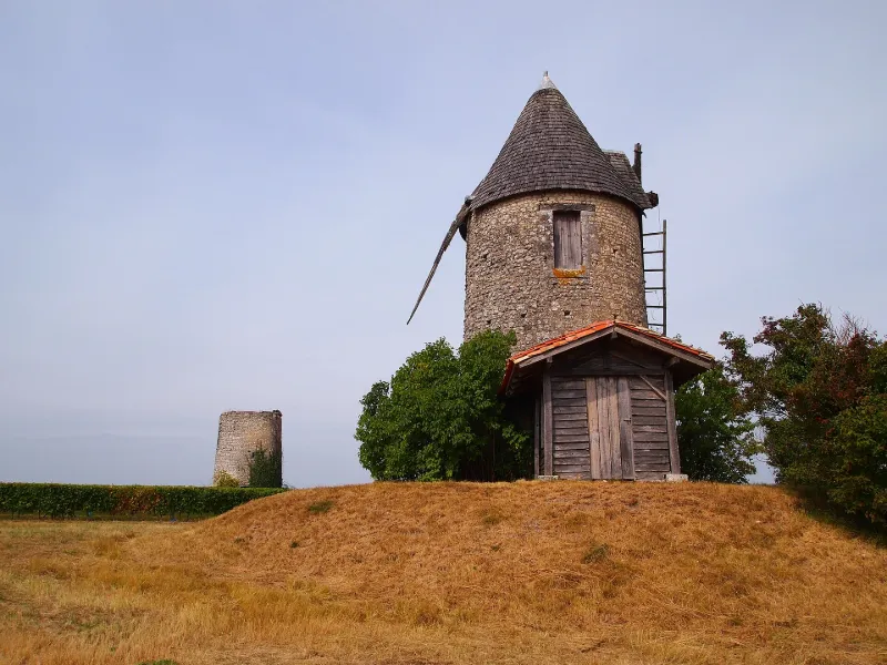
4e quart 18e siècle Le moulin de la Paille - moulin à tour ronde maçonnée construit en 1791-1792 - est l'un des mieux conservés du département. Son corps de moellons, élevé sur un tertre artificiel à proximité d'un second moulin de 1755 ruiné, est entier et coiffé d'une toiture pointue de bardeaux de châtaignier récemment remplacée. Le meunier orientait la toiture tournante du moulin grâce à la perche d'orientation (guivre). La rotation des ailes sous l'action du vent provoquait celle de l'arbre, axe incliné de 15° par rapport à l'horizontale, mettant en marche les mécanismes intérieurs. Le rouet, fixé au centre de l'arbre, entraînait la lanterne qui transmettait son mouvement au gros fer relié à la meule courante. Le grain, versé dans l'oeillard des meules, était broyé plus ou moins finement selon leur écartement que le meunier pouvait régler pour faire varier la mouture. La farine descendait ici par une goulotte jusqu'au rez-de-chaussée du moulin où elle pouvait être mise en sac. Le moulin présente de nombreux éléments d'origine : la porte nord, l'escalier, la goulotte, les meules et leur support, le rouet, des parties de l'arbre et de la perche d'orientation.
Map and restricted areas
Open in the main mapRestricted zones
| Zone | Category | Limits | Conditions |
|---|---|---|---|
| Zrt Alienor Bravo | ZRT | From the ground up to about 240 m above the ground | SUP AIP 223/26 · Du lundi 26 octobre au mercredi 28 octobre 2026 |
Nearby aerodromes
Open aerodromes within 25 km of the spot, heliports included, with their distance and direction from the spot. Near an aerodrome, drone flying is prohibited or height-limited: check the UAS zones map.
| Aerodrome | Type | Distance | Elevation |
|---|---|---|---|
| Chalais Airfield | Aerodrome | 19 km S | 87 m |
| Centre Hospitalier Heliport | Heliport | 24 km NE | 46 m |
Aviation weather (METAR and TAF)
LFBG – Cognac-Châteaubernard (BA 709) Air Base MVFR
METAR
METAR LFBG 171400Z AUTO 22016KT 9999 BKN023 BKN031 BKN082 18/13 Q1000 TEMPO 4000 SHRA SCT030TCU BECMG 25018G28KT
- Wind
- 220°, 30 km/h
- Visibility
- 10 km or more
- Clouds
- Broken (5-7/8) at 2,300 ft (700 m) ; Broken (5-7/8) at 3,100 ft (940 m) ; Broken (5-7/8) at 8,200 ft (2500 m)
- Temperature
- 18 °C, dew point 13 °C
- QNH
- 1000 hPa
- Flight category
- MVFR: ceiling 1,000–3,000 ft or visibility 3–5 mi
TAF
TAF LFBG 170800Z 1709/1809 25018G28KT 9999 BKN020 PROB30 TEMPO 1715/1718 4000 SHRA SCT030TCU TEMPO 1719/1723 24025G35KT 4000 SHRA BKN030TCU PROB40 TEMPO 1720/1722 3000 TSRA BKN025CB TEMPO 1806/1809 4000 SHRA BKN020TCU
| Period (local time) | Change | Wind | Visibility | Weather | Clouds |
|---|---|---|---|---|---|
| 17/11 10:00 → 18/11 10:00 | Initial conditions | 250°, 33 km/h, gusts 52 km/h | 10 km or more | Broken (5-7/8) at 2,000 ft (610 m) | |
| 17/11 16:00 → 17/11 19:00 | Temporarily, probability 30% | 4.0 km | Showers of rain | Scattered (3-4/8) at 3,000 ft (910 m) (towering cumulus) | |
| 17/11 20:00 → 18/11 00:00 | Temporarily | 240°, 46 km/h, gusts 65 km/h | 4.0 km | Showers of rain | Broken (5-7/8) at 3,000 ft (910 m) (towering cumulus) |
| 17/11 21:00 → 17/11 23:00 | Temporarily, probability 40% | 3.0 km | Thunderstorm rain | Broken (5-7/8) at 2,500 ft (760 m) (cumulonimbus) | |
| 18/11 07:00 → 18/11 10:00 | Temporarily | 4.0 km | Showers of rain | Broken (5-7/8) at 2,000 ft (610 m) (towering cumulus) |
Weather and Kp index
Sunrise and sunset
| Day | Dawn | Sunrise | Golden hour | Sunset | Dusk | Day length |
|---|---|---|---|---|---|---|
| Tue 17 Nov | 07:30 | 08:02 | 08:02–08:47 · 16:43–17:28 | 17:28 | 18:00 | 9 h 26 |
| Wed 18 Nov | 07:31 | 08:03 | 08:03–08:49 · 16:42–17:27 | 17:27 | 18:00 | 9 h 24 |
| Thu 19 Nov | 07:32 | 08:04 | 08:04–08:50 · 16:41–17:27 | 17:27 | 17:59 | 9 h 22 |
| Fri 20 Nov | 07:33 | 08:06 | 08:06–08:52 · 16:40–17:26 | 17:26 | 17:58 | 9 h 19 |
| Sat 21 Nov | 07:35 | 08:07 | 08:07–08:53 · 16:39–17:25 | 17:25 | 17:57 | 9 h 17 |
| Sun 22 Nov | 07:36 | 08:08 | 08:08–08:55 · 16:38–17:24 | 17:24 | 17:57 | 9 h 15 |
| Mon 23 Nov | 07:37 | 08:10 | 08:10–08:56 · 16:37–17:23 | 17:23 | 17:56 | 9 h 13 |

Reviews (0)
Log in to review this spot. Log in · Create a free account
No reviews yet. Share yours!