

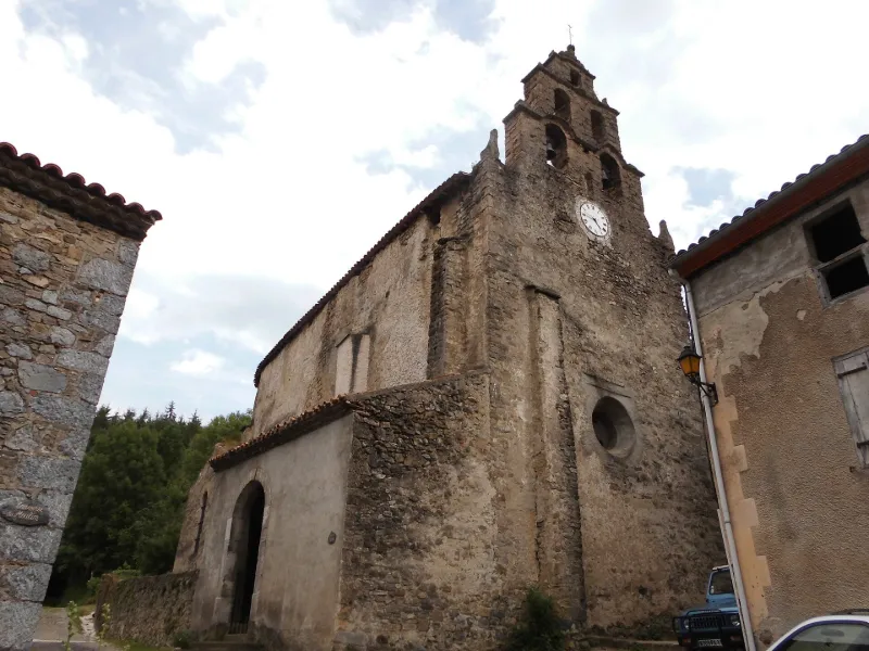
Saint-Loup Parish Church
No reviews yet
Have you flown here? Share your experience with other pilots.
+ Write the first reviewHistory
17e siècle Cette église comptait parmi les dépendances de l'abbaye bénédictine de Joucou, fondée en 873. Elle est citée à partir de 1208. A partir de 1318, les fruits décimaux de Joucou avaient été unis au chapitre de Saint-Paul-de-Fenouillet. A partir de 1459, ce chapitre devient collateur de la cure. L'église primitive, à une nef sans chapelles, avait une abside demi-circulaire ornée de petits contreforts qui paraissent être des lesennes ayant supporté une arcature lombarde. Les murs furent surélevés, ce qui fit disparaître cette arcature, et munis d'archères, probablement au 13e siècle. C'était donc une église fortifiée. Le clocher a probablement été construit au 17e siècle. Elevé sur le mur de fond, le clocher-mur est à cinq baies, superposées en trois étages. Chaque étage est accosté par deux petits pinacles à boules dont les supports quadrangulaires sont posés de biais. Le pignon est cintré et surmonté d'une boule dans laquelle est fichée une croix en fer supportant un coq. Les deux chapelles datent du 19e siècle, ainsi que les fonts baptismaux, la sacristie et le porche.
Map and restricted areas
Open in the main mapRestricted zones
| Zone | Category | Limits | Conditions |
|---|---|---|---|
| Istres | Zone réglementée | 5491 m above sea level → 30766 m above sea level | Vols interdits sauf lorsque the official document of the zone l'autorise explicitement ou avec l'accord du gestionnaire de la zone lorsqu'il est désigné par the official document of the zone |
Nearby aerodromes
Open aerodromes within 25 km of the spot, heliports included, with their distance and direction from the spot. Near an aerodrome, drone flying is prohibited or height-limited: check the UAS zones map.
| Aerodrome | Type | Distance | Elevation |
|---|---|---|---|
| Puivert Airfield | Aerodrome | 13 km NW | 490 m |
| Altiport du Col de la Marrano | Aerodrome | 18 km S | 2,000 m |
| Altisurface du Clos de Legua | Aerodrome | 21 km SW | 2,400 m |
Aviation weather (METAR and TAF)
LFMK – Carcassonne Airport VFR
METAR
METAR LFMK 171400Z AUTO VRB03KT 9999 FEW092/// BKN120/// ///TCU 15/14 Q1004 NOSIG
- Wind
- Variable, 6 km/h
- Visibility
- 10 km or more
- Clouds
- Few (1-2/8) at 9,200 ft (2800 m) ; Broken (5-7/8) at 12,000 ft (3660 m)
- Temperature
- 15 °C, dew point 14 °C
- QNH
- 1004 hPa
- Flight category
- VFR: ceiling > 3,000 ft and visibility > 5 mi
TAF
TAF LFMK 170800Z 1709/1809 08008KT 9999 BKN070 TEMPO 1709/1712 -RA SCT004 BKN010 BECMG 1710/1712 VRB03KT TEMPO 1712/1720 SCT025TCU BECMG 1720/1722 CAVOK PROB30 TEMPO 1801/1807 3000 BR BECMG 1806/1808 27010KT 4000 RA BKN020 BKN030
| Period (local time) | Change | Wind | Visibility | Weather | Clouds |
|---|---|---|---|---|---|
| 17/11 10:00 → 17/11 11:00 | Initial conditions | 080°, 15 km/h | 10 km or more | Broken (5-7/8) at 7,000 ft (2130 m) | |
| 17/11 10:00 → 17/11 13:00 | Temporarily | Rain light | Scattered (3-4/8) at 400 ft (120 m) ; Broken (5-7/8) at 1,000 ft (300 m) | ||
| 17/11 11:00 → 17/11 21:00 | Becoming | Variable, 6 km/h | 10 km or more | Broken (5-7/8) at 7,000 ft (2130 m) | |
| 17/11 13:00 → 17/11 21:00 | Temporarily | Scattered (3-4/8) at 2,500 ft (760 m) (towering cumulus) | |||
| 17/11 21:00 → 18/11 07:00 | Becoming | Variable, 6 km/h | 10 km or more | No significant weather | No significant cloud |
| 18/11 02:00 → 18/11 08:00 | Temporarily, probability 30% | 3.0 km | Mist | ||
| 18/11 07:00 → 18/11 10:00 | Becoming | 270°, 19 km/h | 4.0 km | Rain | Broken (5-7/8) at 2,000 ft (610 m) ; Broken (5-7/8) at 3,000 ft (910 m) |
Weather and Kp index
Sunrise and sunset
| Day | Dawn | Sunrise | Golden hour | Sunset | Dusk | Day length |
|---|---|---|---|---|---|---|
| Tue 17 Nov | 07:15 | 07:46 | 07:46–08:29 · 16:44–17:27 | 17:27 | 17:57 | 9 h 41 |
| Wed 18 Nov | 07:16 | 07:47 | 07:47–08:30 · 16:43–17:26 | 17:26 | 17:57 | 9 h 38 |
| Thu 19 Nov | 07:18 | 07:48 | 07:48–08:31 · 16:42–17:25 | 17:25 | 17:56 | 9 h 36 |
| Fri 20 Nov | 07:19 | 07:50 | 07:50–08:33 · 16:41–17:24 | 17:24 | 17:55 | 9 h 34 |
| Sat 21 Nov | 07:20 | 07:51 | 07:51–08:34 · 16:40–17:24 | 17:24 | 17:55 | 9 h 33 |
| Sun 22 Nov | 07:21 | 07:52 | 07:52–08:36 · 16:39–17:23 | 17:23 | 17:54 | 9 h 31 |
| Mon 23 Nov | 07:22 | 07:53 | 07:53–08:37 · 16:39–17:22 | 17:22 | 17:53 | 9 h 29 |

Reviews (0)
Log in to review this spot. Log in · Create a free account
No reviews yet. Share yours!