

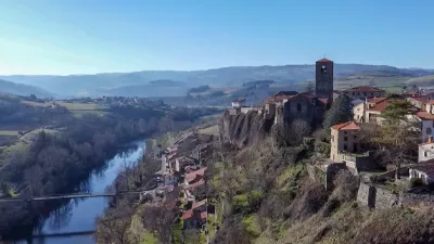
Vauclair Chapel
No reviews yet
Have you flown here? Share your experience with other pilots.
+ Write the first reviewHistory
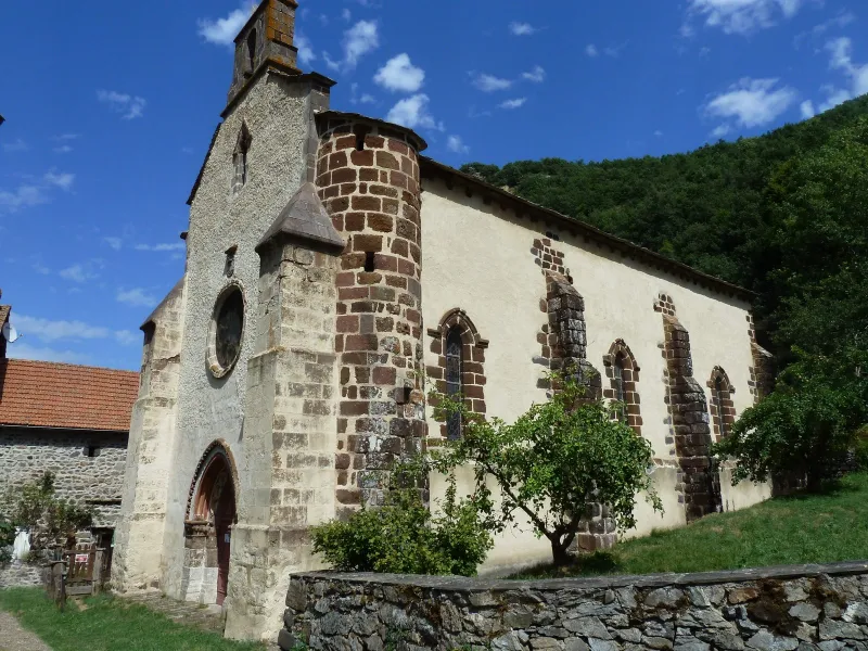
13e siècle ; 14e siècle Cette chapelle faisait partie d'un prieuré de l'ordre de la Couronne, à la collation du chapitre cathédral de Saint-Flou. L'édifice, construit en un style étranger à la région, peut remonter au début du 13e siècle. A l'intérieur, nef unique divisée en trois travées par des murs droits. Le portail occidental présente une première archivolte ornée de neuf lobes lancéolés, chacun inscrivant une quinte feuille ajourée. Il se compose également de deux pieds-droits, formant retrait, couronnés d'un chapiteau décoré d'une rangée de perles réunies par un cordon enlacé. Au-dessus de la porte, une rose éclaire la nef.
Map and restricted areas
Open in the main mapRestricted zones
| Zone | Category | Limits | Conditions |
|---|---|---|---|
| SETBA Secteur ARDÈCHE | Entrainement Militaire | 0 m above ground level → 15241 m above ground level | Pilotage de drones en vue directe : les aéronefs dont la masse est supérieure à 900 grammes sont soumis à notification préalable selon des modalités publiées sur le site www.ecologie.gouv.fr |
| Zrt Echo Low | ZRT | From the ground up to about 4,100 m above sea level | SUP AIP 219/26 · Du mardi 20 octobre au jeudi 22 octobre 2026 |
| Zrt Aumont High | ZRT | FL 175 / FL 185 | SUP AIP 055/26 · Du jeudi 16 avril 2026 au mercredi 12 avril 2028 |
Nearby aerodromes
Open aerodromes within 25 km of the spot, heliports included, with their distance and direction from the spot. Near an aerodrome, drone flying is prohibited or height-limited: check the UAS zones map.
| Aerodrome | Type | Distance | Elevation |
|---|---|---|---|
| Saint-Flour-Coltines Airport | Aerodrome | 17 km SW | 981 m |
| Brioude Beaumont Airport | Aerodrome | 24 km NE | 452 m |
Aviation weather (METAR and TAF)
No METAR station within 50 km.
Weather and Kp index
Sunrise and sunset
| Day | Dawn | Sunrise | Golden hour | Sunset | Dusk | Day length |
|---|---|---|---|---|---|---|
| Tue 17 Nov | 07:17 | 07:49 | 07:49–08:34 · 16:31–17:17 | 17:17 | 17:49 | 9 h 28 |
| Wed 18 Nov | 07:18 | 07:50 | 07:50–08:35 · 16:30–17:16 | 17:16 | 17:48 | 9 h 25 |
| Thu 19 Nov | 07:19 | 07:51 | 07:51–08:37 · 16:29–17:15 | 17:15 | 17:47 | 9 h 23 |
| Fri 20 Nov | 07:20 | 07:53 | 07:53–08:38 · 16:28–17:14 | 17:14 | 17:46 | 9 h 21 |
| Sat 21 Nov | 07:22 | 07:54 | 07:54–08:40 · 16:27–17:13 | 17:13 | 17:45 | 9 h 19 |
| Sun 22 Nov | 07:23 | 07:55 | 07:55–08:41 · 16:26–17:12 | 17:12 | 17:45 | 9 h 17 |
| Mon 23 Nov | 07:24 | 07:56 | 07:56–08:43 · 16:25–17:12 | 17:12 | 17:44 | 9 h 15 |
Reviews (0)
Log in to review this spot. Log in · Create a free account
No reviews yet. Share yours!