

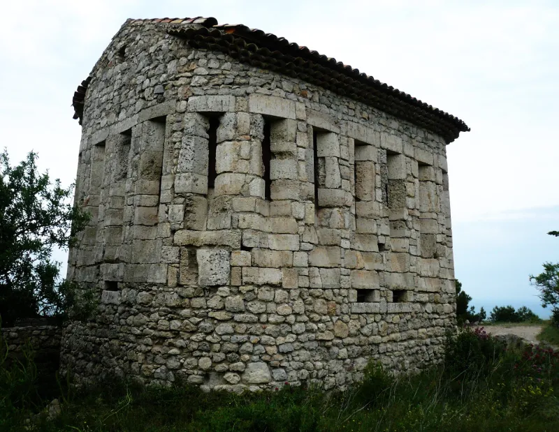
Former Beacon, called Redoute de la Franqui
No reviews yet
Have you flown here? Share your experience with other pilots.
+ Write the first reviewHistory
18e siècle La redoute de la Franqui à Leucate n 'est pas un phare mais un fort destiné à la surveillance de la côte construit au 18e siècle. C'est une construction rectangulaire dont les angles sont arrondis, présentant l'aspect général d'un temple grec. Le niveau bas est occupé, à chaque extrémité du grand axe, par une petite ouverture rectangulaire. Immédiatement au-dessus commencent de longues fentes à double ébrasement, en grand appareil taillé, faisant le tour de l'édifice, l'une touchant l'autre. Deux portes rectangulaires mais inégales s'ouvrent au nord-est, vers la mer. Les deux portes donnent sur une plate-forme en demi-cercle surplombant la falaise et le rivage. Elle est séparée de l'édifice par un mur et un couloir terminé par deux murettes qui viennent se raccorder aux deux angles du bâtiment. A l'extérieur, la plate-forme forme talus et s'y distingue la base de larges créneaux, probablement embrasures à canons. Le sommet de la construction est fait en appareil irrégulier et présente les traces d'un toit à double pente.
Map and restricted areas
Open in the main mapRestricted zones
| Zone | Category | Limits | Conditions |
|---|---|---|---|
| Falaise Cap Leucate (11) | Activité de loisirs | 0 m above ground level → 101 m above ground level | Flights reserved for members and guests of the club, under the terms set by the model-aircraft field manager |
| Zit Leucate | ZIT | From the ground up to about 150 m above the ground | SUP AIP 052/26 · Du jeudi 16 avril 2026 au mercredi 24 novembre 2027 |
| Istres | Zone réglementée | 5491 m above sea level → 30766 m above sea level | Vols interdits sauf lorsque the official document of the zone l'autorise explicitement ou avec l'accord du gestionnaire de la zone lorsqu'il est désigné par the official document of the zone |
| Istres | Zone réglementée | 5491 m above sea level → 30766 m above sea level | Vols interdits sauf lorsque the official document of the zone l'autorise explicitement ou avec l'accord du gestionnaire de la zone lorsqu'il est désigné par the official document of the zone |
| Zrt/zdt Lima 2 | ZRT/ZDT | FL 195 / FL 285 | SUP AIP 219/26 · Du mardi 20 octobre au jeudi 22 octobre 2026 |
Nearby aerodromes
Open aerodromes within 25 km of the spot, heliports included, with their distance and direction from the spot. Near an aerodrome, drone flying is prohibited or height-limited: check the UAS zones map.
| Aerodrome | Type | Distance | Elevation |
|---|---|---|---|
| Base Hydro-ULM La Salanque Latécoère | Seaplane base | 13 km S | 0 m |
| St Laurent de la Salanque Airbase | Aerodrome | 15 km S | 9 m |
Aviation weather (METAR and TAF)
LFMP – Perpignan-Rivesaltes (Llabanère) Airport VFR
METAR
METAR LFMP 171400Z AUTO 12005KT 090V150 CAVOK 16/13 Q1005 NOSIG
- Wind
- 120°, 9 km/h
- Visibility
- 10 km or more
- Clouds
- –
- Temperature
- 16 °C, dew point 13 °C
- QNH
- 1005 hPa
- Flight category
- VFR: ceiling > 3,000 ft and visibility > 5 mi
TAF
TAF LFMP 170800Z 1709/1809 VRB02KT 9999 BKN008 BECMG 1710/1712 CAVOK BECMG 1806/1808 28012KT
| Period (local time) | Change | Wind | Visibility | Weather | Clouds |
|---|---|---|---|---|---|
| 17/11 10:00 → 17/11 11:00 | Initial conditions | Variable, 4 km/h | 10 km or more | Broken (5-7/8) at 800 ft (240 m) | |
| 17/11 11:00 → 18/11 07:00 | Becoming | Variable, 4 km/h | 10 km or more | No significant weather | No significant cloud |
| 18/11 07:00 → 18/11 10:00 | Becoming | 280°, 22 km/h | 10 km or more | No significant weather | No significant cloud |
Weather and Kp index
Sunrise and sunset
| Day | Dawn | Sunrise | Golden hour | Sunset | Dusk | Day length |
|---|---|---|---|---|---|---|
| Tue 17 Nov | 07:12 | 07:43 | 07:43–08:25 · 16:40–17:23 | 17:23 | 17:54 | 9 h 40 |
| Wed 18 Nov | 07:13 | 07:44 | 07:44–08:27 · 16:39–17:22 | 17:22 | 17:53 | 9 h 38 |
| Thu 19 Nov | 07:14 | 07:45 | 07:45–08:28 · 16:38–17:21 | 17:21 | 17:52 | 9 h 36 |
| Fri 20 Nov | 07:15 | 07:46 | 07:46–08:30 · 16:37–17:21 | 17:21 | 17:51 | 9 h 34 |
| Sat 21 Nov | 07:17 | 07:47 | 07:47–08:31 · 16:36–17:20 | 17:20 | 17:51 | 9 h 32 |
| Sun 22 Nov | 07:18 | 07:49 | 07:49–08:32 · 16:35–17:19 | 17:19 | 17:50 | 9 h 30 |
| Mon 23 Nov | 07:19 | 07:50 | 07:50–08:34 · 16:35–17:19 | 17:19 | 17:50 | 9 h 28 |

Reviews (0)
Log in to review this spot. Log in · Create a free account
No reviews yet. Share yours!