

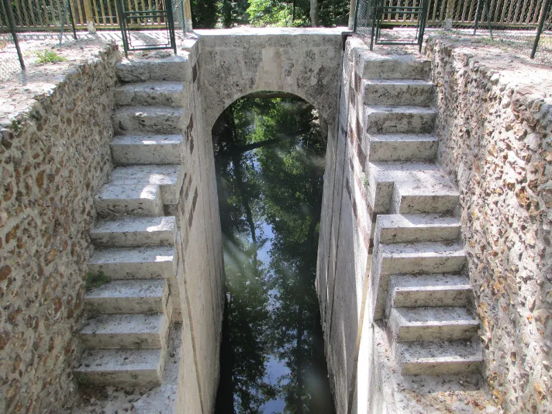
Former Aqueduct from Pontgouin to Versailles
No reviews yet
Have you flown here? Share your experience with other pilots.
+ Write the first reviewHistory
4e quart 17e siècle Les travaux d'adduction des eaux de l'Eure à Versailles en passant par Maintenon, menés sous Louis XIV, ont été en partie réalisés. Sur le plateau entre Chartres et Maintenon subsistent, sur plusieurs kilomètres, d'importants terrassements formant levée pour porter le canal. Sous ces terrassements subsistent d'importants ouvrages d'art : tunels pour le passage des routes, siphons et aqueducs pour l'évacuation des eaux des vallées barrées par les terrassements. Les écluses et la digue de Boizard, destinées à recevoir les eaux de captation, seraient l'oeuvre de Vauban.
Map and restricted areas
Open in the main mapRestricted zones
| Zone | Category | Limits | Conditions |
|---|---|---|---|
| Paris 9 | Zone réglementée | 2138 m above sea level → 3821 m above sea level | Vols interdits sauf lorsque the official document of the zone l'autorise explicitement ou avec l'accord du gestionnaire de la zone lorsqu'il est désigné par the official document of the zone |
Nearby aerodromes
Open aerodromes within 25 km of the spot, heliports included, with their distance and direction from the spot. Near an aerodrome, drone flying is prohibited or height-limited: check the UAS zones map.
| Aerodrome | Type | Distance | Elevation |
|---|---|---|---|
| Champrond le Petit Bois Landry base ULM | Aerodrome | 12 km SW | 260 m |
Aviation weather (METAR and TAF)
No METAR station within 50 km.
Weather and Kp index
| Day | Weather | Temp. min. / max. | Wind | Rain | Max Kp |
|---|---|---|---|---|---|
| Tue 17 Nov | Light rain | 10° / 13° | 36 km/h SW | 3.9 mm | 5 |
| Wed 18 Nov | Showers | 9° / 12° | 35 km/h SW | 5.4 mm | 5 |
| Thu 19 Nov | Showers | 8° / 12° | 33 km/h SW | 2.9 mm | 3 |
| Fri 20 Nov | Showers | 8° / 12° | 30 km/h SW | 3.1 mm | 3 |
| Sat 21 Nov | Partly cloudy | 7° / 11° | 24 km/h W | 0.1 mm | – |
| Sun 22 Nov | Showers | 6° / 10° | 24 km/h SW | 13 mm | – |
| Mon 23 Nov | Clear sky | 5° / 10° | 22 km/h W | 0.2 mm | – |
Hour by hour: Tuesday 17 November
| Time | Weather | Temp. | Wind | Rain | Clouds | Kp |
|---|---|---|---|---|---|---|
| 15:00 | Light rain | 13° | 33 km/h SW | 0.1 mm | 97 % | 4 |
| 16:00 | Light rain | 13° | 36 km/h SW | 0.2 mm | 98 % | 4 |
| 17:00 | Rain | 12° | 35 km/h SW | 0.8 mm | 100 % | 4 |
| 18:00 | Heavy rain | 11° | 31 km/h SW | 2.0 mm | 100 % | 4 |
| 19:00 | Rain | 10° | 33 km/h SW | 0.4 mm | 100 % | 5 |
| 20:00 | Light rain | 10° | 32 km/h SW | 0.2 mm | 100 % | 5 |
| 21:00 | Light rain | 11° | 28 km/h SW | 0.2 mm | 100 % | 5 |
| 22:00 | Cloudy | 11° | 30 km/h SW | – | 100 % | 5 |
Hour by hour: Wednesday 18 November
| Time | Weather | Temp. | Wind | Rain | Clouds | Kp |
|---|---|---|---|---|---|---|
| 06:00 | Light rain | 9° | 26 km/h SW | 0.1 mm | 98 % | 4 |
| 07:00 | Cloudy | 9° | 26 km/h SW | – | 100 % | 4 |
| 08:00 | Cloudy | 9° | 27 km/h SW | – | 100 % | 4 |
| 09:00 | Cloudy | 10° | 27 km/h SW | – | 100 % | 4 |
| 10:00 | Showers | 10° | 30 km/h SW | 0.2 mm | 77 % | 4 |
| 11:00 | Showers | 11° | 31 km/h SW | 0.1 mm | 34 % | 4 |
| 12:00 | Partly cloudy | 12° | 33 km/h SW | – | 66 % | 4 |
| 13:00 | Showers | 12° | 35 km/h SW | 0.2 mm | 56 % | 3 |
| 14:00 | Showers | 12° | 31 km/h SW | 0.2 mm | 20 % | 3 |
| 15:00 | Clear sky | 12° | 29 km/h SW | – | 12 % | 3 |
| 16:00 | Clear sky | 12° | 26 km/h SW | – | 8 % | 3 |
| 17:00 | Partly cloudy | 11° | 24 km/h SW | – | 55 % | 3 |
| 18:00 | Partly cloudy | 10° | 23 km/h SW | – | 91 % | 3 |
| 19:00 | Light rain | 10° | 22 km/h SW | 0.3 mm | 100 % | 2 |
| 20:00 | Rain | 10° | 23 km/h SW | 0.8 mm | 100 % | 2 |
| 21:00 | Heavy rain | 10° | 24 km/h SW | 1.4 mm | 100 % | 2 |
| 22:00 | Heavy rain | 9° | 26 km/h S | 1.4 mm | 100 % | 2 |
Sunrise and sunset
| Day | Dawn | Sunrise | Golden hour | Sunset | Dusk | Day length |
|---|---|---|---|---|---|---|
| Tue 17 Nov | 07:32 | 08:06 | 08:06–08:56 · 16:25–17:14 | 17:14 | 17:49 | 9 h 08 |
| Wed 18 Nov | 07:33 | 08:08 | 08:08–08:58 · 16:24–17:13 | 17:13 | 17:48 | 9 h 05 |
| Thu 19 Nov | 07:35 | 08:09 | 08:09–08:59 · 16:22–17:12 | 17:12 | 17:47 | 9 h 02 |
| Fri 20 Nov | 07:36 | 08:11 | 08:11–09:01 · 16:21–17:11 | 17:11 | 17:46 | 9 h 00 |
| Sat 21 Nov | 07:38 | 08:12 | 08:12–09:03 · 16:20–17:10 | 17:10 | 17:45 | 8 h 57 |
| Sun 22 Nov | 07:39 | 08:14 | 08:14–09:04 · 16:19–17:09 | 17:09 | 17:44 | 8 h 55 |
| Mon 23 Nov | 07:40 | 08:15 | 08:15–09:06 · 16:18–17:08 | 17:08 | 17:43 | 8 h 53 |



Reviews (0)
Log in to review this spot. Log in · Create a free account
No reviews yet. Share yours!