

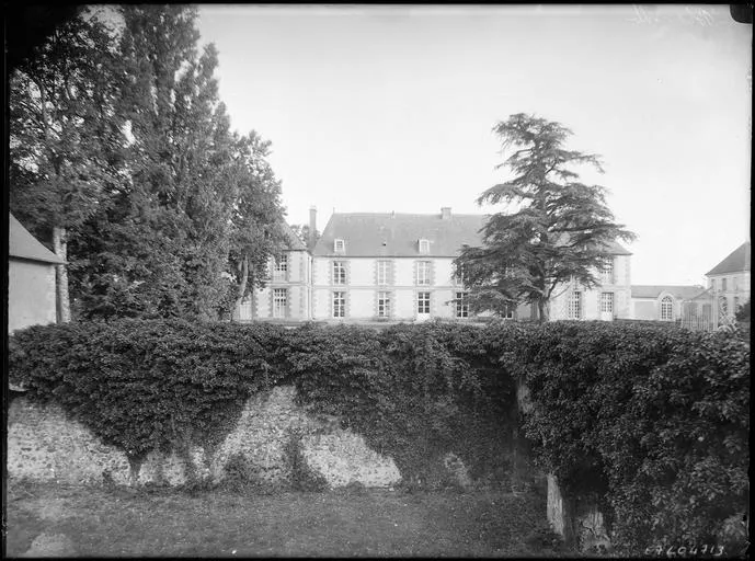
Blanville Castle
No reviews yet
Have you flown here? Share your experience with other pilots.
+ Write the first reviewHistory
2e quart 17e siècle ; 18e siècle Les premiers seigneurs de Blanville apparaissent à la fin du 16e siècle. Le château, bâti en 1643 pour Du Cluzel, intendant de Touraine, est constitué d'un corps de bâtiment principal, flanqué de deux courtes ailes. Les communs qui prolongent le château de part et d'autre, se retournent, limitant une grande cour rectangulaire. Les douves, qui recoupent ce grand rectangle, sont accusées aux angles opposés au château, par deux petits pavillons carrés. Dans la perspective du château se trouvent le jardin à la française, puis un grand tapis vert.
Map and restricted areas
Open in the main mapRestricted zones
| Zone | Category | Limits | Conditions |
|---|---|---|---|
| Voltac Gih | Entrainement Militaire | 0 m above ground level → 15241 m above ground level | Pilotage de drones en vue directe : les aéronefs dont la masse est supérieure à 900 grammes sont soumis à notification préalable selon des modalités publiées sur le site www.ecologie.gouv.fr |
| Paris 7 | Zone réglementée | 1529 m above sea level → 2907 m above sea level | Vols interdits sauf lorsque the official document of the zone l'autorise explicitement ou avec l'accord du gestionnaire de la zone lorsqu'il est désigné par the official document of the zone |
| Paris 9 | Zone réglementée | 2138 m above sea level → 3821 m above sea level | Vols interdits sauf lorsque the official document of the zone l'autorise explicitement ou avec l'accord du gestionnaire de la zone lorsqu'il est désigné par the official document of the zone |
Nearby aerodromes
Open aerodromes within 25 km of the spot, heliports included, with their distance and direction from the spot. Near an aerodrome, drone flying is prohibited or height-limited: check the UAS zones map.
| Aerodrome | Type | Distance | Elevation |
|---|---|---|---|
| Centre Hospitalier Heliport | Heliport | 15 km E | 149 m |
| Aérodrome de Chartres-Métropole | Aerodrome | 17 km E | 155 m |
| Champrond le Petit Bois Landry base ULM | Aerodrome | 18 km W | 260 m |
Aviation weather (METAR and TAF)
No METAR station within 50 km.
Weather and Kp index
| Day | Weather | Temp. min. / max. | Wind | Rain | Max Kp |
|---|---|---|---|---|---|
| Tue 17 Nov | Light rain | 10° / 14° | 36 km/h SW | 3.3 mm | 5 |
| Wed 18 Nov | Showers | 10° / 13° | 35 km/h W | 5.3 mm | 5 |
| Thu 19 Nov | Light rain | 8° / 12° | 33 km/h SW | 2.8 mm | 3 |
| Fri 20 Nov | Showers | 9° / 12° | 29 km/h SW | 1.8 mm | 3 |
| Sat 21 Nov | Cloudy | 7° / 11° | 27 km/h W | – | – |
| Sun 22 Nov | Light rain | 6° / 11° | 27 km/h W | 11 mm | – |
| Mon 23 Nov | Clear sky | 6° / 10° | 22 km/h W | 0.5 mm | – |
Hour by hour: Tuesday 17 November
| Time | Weather | Temp. | Wind | Rain | Clouds | Kp |
|---|---|---|---|---|---|---|
| 15:00 | Light rain | 14° | 32 km/h SW | 0.1 mm | 88 % | 4 |
| 16:00 | Cloudy | 14° | 36 km/h SW | – | 98 % | 4 |
| 17:00 | Light rain | 13° | 35 km/h SW | 0.1 mm | 100 % | 4 |
| 18:00 | Heavy rain | 12° | 31 km/h SW | 1.8 mm | 100 % | 4 |
| 19:00 | Rain | 11° | 33 km/h SW | 0.7 mm | 100 % | 5 |
| 20:00 | Rain | 11° | 31 km/h SW | 0.4 mm | 100 % | 5 |
| 21:00 | Light rain | 11° | 32 km/h SW | 0.2 mm | 100 % | 5 |
| 22:00 | Partly cloudy | 11° | 31 km/h SW | – | 75 % | 5 |
Hour by hour: Wednesday 18 November
| Time | Weather | Temp. | Wind | Rain | Clouds | Kp |
|---|---|---|---|---|---|---|
| 06:00 | Cloudy | 10° | 27 km/h SW | – | 97 % | 4 |
| 07:00 | Cloudy | 10° | 27 km/h SW | – | 100 % | 4 |
| 08:00 | Cloudy | 10° | 27 km/h SW | – | 100 % | 4 |
| 09:00 | Cloudy | 10° | 27 km/h SW | – | 94 % | 4 |
| 10:00 | Showers | 11° | 28 km/h SW | 0.1 mm | 52 % | 4 |
| 11:00 | Showers | 12° | 31 km/h SW | 0.1 mm | 23 % | 4 |
| 12:00 | Fair | 12° | 34 km/h SW | – | 22 % | 4 |
| 13:00 | Showers | 13° | 35 km/h W | 0.2 mm | 69 % | 3 |
| 14:00 | Showers | 13° | 31 km/h SW | 0.1 mm | 23 % | 3 |
| 15:00 | Fair | 13° | 30 km/h SW | – | 16 % | 3 |
| 16:00 | Clear sky | 12° | 26 km/h SW | – | 12 % | 3 |
| 17:00 | Fair | 11° | 24 km/h SW | – | 38 % | 3 |
| 18:00 | Partly cloudy | 11° | 22 km/h SW | – | 86 % | 3 |
| 19:00 | Light rain | 10° | 21 km/h SW | 0.1 mm | 99 % | 2 |
| 20:00 | Rain | 10° | 22 km/h SW | 0.5 mm | 100 % | 2 |
| 21:00 | Heavy rain | 10° | 24 km/h SW | 1.4 mm | 100 % | 2 |
| 22:00 | Heavy rain | 10° | 25 km/h S | 1.4 mm | 100 % | 2 |
Sunrise and sunset
| Day | Dawn | Sunrise | Golden hour | Sunset | Dusk | Day length |
|---|---|---|---|---|---|---|
| Tue 17 Nov | 07:31 | 08:06 | 08:06–08:55 · 16:25–17:14 | 17:14 | 17:48 | 9 h 08 |
| Wed 18 Nov | 07:33 | 08:07 | 08:07–08:57 · 16:23–17:13 | 17:13 | 17:47 | 9 h 05 |
| Thu 19 Nov | 07:34 | 08:09 | 08:09–08:58 · 16:22–17:12 | 17:12 | 17:46 | 9 h 03 |
| Fri 20 Nov | 07:35 | 08:10 | 08:10–09:00 · 16:21–17:11 | 17:11 | 17:45 | 9 h 00 |
| Sat 21 Nov | 07:37 | 08:11 | 08:11–09:02 · 16:20–17:10 | 17:10 | 17:45 | 8 h 58 |
| Sun 22 Nov | 07:38 | 08:13 | 08:13–09:03 · 16:18–17:09 | 17:09 | 17:44 | 8 h 56 |
| Mon 23 Nov | 07:39 | 08:14 | 08:14–09:05 · 16:17–17:08 | 17:08 | 17:43 | 8 h 53 |

Reviews (0)
Log in to review this spot. Log in · Create a free account
No reviews yet. Share yours!