

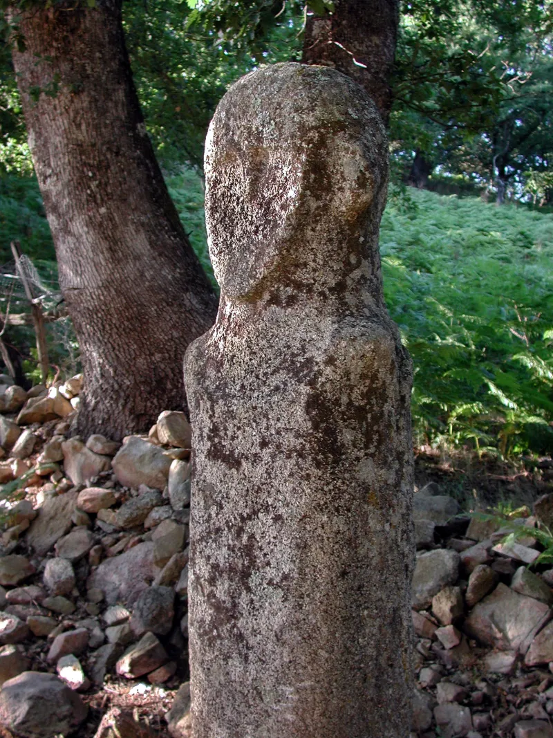
Tavera Statue-Menhir
No reviews yet
Have you flown here? Share your experience with other pilots.
+ Write the first reviewHistory
Age du bronze ; Néolithique L'architecture mégalithique en Corse se développe dans un contexte de cultures sédentarisées. Cette statue-menhir a été découverte au début de l'année 1961. Elle gisait, entière, quasiment enterrée, à quelques mètres de l'endroit où elle est actuellement visible, à proximité d'un castellu, fortification médiévale probablement implantée sur une occupation antique et protohistorique du second âge du fer. Les fouilles menées autour de l'emplacement ont permis de découvrir des vestiges possible d'un dispositif de calage ainsi que du mobilier lithique daté de la fin du Néolithique ou du début de l'âge du bronze. ££D'une hauteur de 2,42m, la statue-menhir sculptée en ronde-bosse dans du granit, est l'une des silhouettes les plus anatomiques de l'île. La tête arrondie présente deux reliefs saillants au niveau des oreilles, un bloc nez-arcade en relief, des yeux rapprochés en creux et une bouche fermée figurée par une courte gravure. A l'emplacement de la ligne claviculaire, un arc de cercle en relief relie les épaules saillantes. Des gravures de croisillons (aujourd'hui disparues) évoquaient une chevelure ou une résille. La face postérieure des épaules en relief et l'emplacement de la colonne vertébrale en creux constitue par ailleurs un schéma classique observé sur bon nombre de statues-menhirs insulaires.£
Map and restricted areas
Open in the main mapRestricted zones
| Zone | Category | Limits | Conditions |
|---|---|---|---|
| Tma Ajaccio |
Région de contrôle terminal | 305 m above ground level → 3821 m above sea level · 610 m above ground level → 3821 m above sea level · 610 m above ground level → 3821 m above sea level · 762 m above sea level → 3821 m above sea level · 762 m above sea level → 3821 m above sea level · 1676 m above sea level → 3821 m above sea level · 1676 m above sea level → 3821 m above sea level · 2138 m above sea level → 3821 m above sea level | Drone flights inside this zone are forbidden without the prior agreement of air traffic control |
| Zena Med | Zone dangereuse | 5491 m above sea level → 9003 m above sea level | Vols interdits sauf lorsque the official document of the zone l'autorise explicitement ou avec l'accord du gestionnaire de la zone lorsqu'il est désigné par the official document of the zone |
Nearby aerodromes
Open aerodromes within 25 km of the spot, heliports included, with their distance and direction from the spot. Near an aerodrome, drone flying is prohibited or height-limited: check the UAS zones map.
| Aerodrome | Type | Distance | Elevation |
|---|---|---|---|
| Ajaccio-Napoléon Bonaparte Airport | Airport | 22 km SW | 5 m |
Aviation weather (METAR and TAF)
LFKJ – Ajaccio-Napoléon Bonaparte Airport MVFR
METAR
METAR LFKJ 171400Z AUTO 21011KT 9000 BKN023/// BKN032/// BKN041/// ///TCU 20/18 Q1008 NOSIG
- Wind
- 210°, 20 km/h
- Visibility
- 9 km
- Clouds
- Broken (5-7/8) at 2,300 ft (700 m) ; Broken (5-7/8) at 3,200 ft (980 m) ; Broken (5-7/8) at 4,100 ft (1250 m)
- Temperature
- 20 °C, dew point 18 °C
- QNH
- 1008 hPa
- Flight category
- MVFR: ceiling 1,000–3,000 ft or visibility 3–5 mi
TAF
TAF LFKJ 170800Z 1709/1809 VRB05KT 9999 BKN020 BECMG 1709/1710 22014KT TEMPO 1709/1724 -SHRA SCT020TCU BECMG 1722/1724 VRB02KT
| Period (local time) | Change | Wind | Visibility | Weather | Clouds |
|---|---|---|---|---|---|
| 17/11 10:00 → 18/11 10:00 | Initial conditions | Variable, 9 km/h | 10 km or more | Broken (5-7/8) at 2,000 ft (610 m) | |
| 17/11 10:00 → 18/11 01:00 | Temporarily | Showers of rain light | Scattered (3-4/8) at 2,000 ft (610 m) (towering cumulus) | ||
| 17/11 10:00 → 17/11 23:00 | Becoming | 220°, 26 km/h | 10 km or more | Broken (5-7/8) at 2,000 ft (610 m) | |
| 17/11 23:00 → 18/11 10:00 | Becoming | Variable, 4 km/h | 10 km or more | Broken (5-7/8) at 2,000 ft (610 m) |
Weather and Kp index
| Day | Weather | Temp. min. / max. | Wind | Rain | Max Kp |
|---|---|---|---|---|---|
| Tue 17 Nov | Heavy rain | 13° / 14° | 22 km/h SW | 16 mm | 5 |
| Wed 18 Nov | Showers | 11° / 16° | 22 km/h W | 9.6 mm | 5 |
| Thu 19 Nov | Cloudy | 9° / 16° | 33 km/h W | 40 mm | 3 |
| Fri 20 Nov | Showers | 8° / 10° | 21 km/h W | 6.6 mm | 3 |
| Sat 21 Nov | Showers | 10° / 12° | 15 km/h W | 3.4 mm | – |
| Sun 22 Nov | Rain | 9° / 12° | 13 km/h W | 7.1 mm | – |
| Mon 23 Nov | Partly cloudy | 8° / 12° | 18 km/h W | 0.2 mm | – |
Hour by hour: Tuesday 17 November
| Time | Weather | Temp. | Wind | Rain | Clouds | Kp |
|---|---|---|---|---|---|---|
| 15:00 | Heavy rain | 13° | 22 km/h SW | 1.3 mm | 100 % | 4 |
| 16:00 | Heavy rain | 14° | 21 km/h SW | 1.1 mm | 100 % | 4 |
| 17:00 | Heavy rain | 13° | 19 km/h SW | 2.0 mm | 100 % | 4 |
| 18:00 | Heavy rain | 13° | 17 km/h SW | 2.7 mm | 100 % | 4 |
| 19:00 | Heavy rain | 14° | 17 km/h SW | 1.5 mm | 100 % | 5 |
| 20:00 | Heavy rain | 14° | 17 km/h SW | 1.2 mm | 100 % | 5 |
| 21:00 | Rain | 14° | 17 km/h SW | 0.8 mm | 100 % | 5 |
| 22:00 | Heavy rain | 14° | 17 km/h SW | 1.7 mm | 100 % | 5 |
Hour by hour: Wednesday 18 November
| Time | Weather | Temp. | Wind | Rain | Clouds | Kp |
|---|---|---|---|---|---|---|
| 06:00 | Fog | 14° | 14 km/h SW | – | 100 % | 4 |
| 07:00 | Fog | 13° | 11 km/h SW | – | 98 % | 4 |
| 08:00 | Fog | 13° | 12 km/h W | – | 99 % | 4 |
| 09:00 | Light rain | 13° | 13 km/h W | 0.1 mm | 100 % | 4 |
| 10:00 | Light rain | 14° | 15 km/h W | 0.1 mm | 95 % | 4 |
| 11:00 | Partly cloudy | 15° | 19 km/h W | – | 54 % | 4 |
| 12:00 | Partly cloudy | 16° | 21 km/h W | – | 46 % | 4 |
| 13:00 | Showers | 16° | 22 km/h W | 0.2 mm | 46 % | 3 |
| 14:00 | Fair | 15° | 21 km/h W | – | 29 % | 3 |
| 15:00 | Partly cloudy | 15° | 20 km/h W | – | 52 % | 3 |
| 16:00 | Partly cloudy | 14° | 17 km/h W | – | 47 % | 3 |
| 17:00 | Cloudy | 13° | 14 km/h W | – | 91 % | 3 |
| 18:00 | Cloudy | 13° | 16 km/h W | – | 94 % | 3 |
| 19:00 | Cloudy | 13° | 16 km/h W | – | 91 % | 2 |
| 20:00 | Partly cloudy | 13° | 16 km/h W | – | 81 % | 2 |
| 21:00 | Partly cloudy | 12° | 14 km/h W | – | 72 % | 2 |
| 22:00 | Partly cloudy | 11° | 12 km/h W | – | 83 % | 2 |
Sunrise and sunset
| Day | Dawn | Sunrise | Golden hour | Sunset | Dusk | Day length |
|---|---|---|---|---|---|---|
| Tue 17 Nov | 06:46 | 07:17 | 07:17–07:59 · 16:19–17:01 | 17:01 | 17:32 | 9 h 44 |
| Wed 18 Nov | 06:48 | 07:18 | 07:18–08:00 · 16:18–17:01 | 17:01 | 17:31 | 9 h 42 |
| Thu 19 Nov | 06:49 | 07:19 | 07:19–08:01 · 16:17–17:00 | 17:00 | 17:30 | 9 h 40 |
| Fri 20 Nov | 06:50 | 07:20 | 07:20–08:03 · 16:17–16:59 | 16:59 | 17:29 | 9 h 39 |
| Sat 21 Nov | 06:51 | 07:21 | 07:21–08:04 · 16:16–16:58 | 16:58 | 17:29 | 9 h 37 |
| Sun 22 Nov | 06:52 | 07:23 | 07:23–08:05 · 16:15–16:58 | 16:58 | 17:28 | 9 h 35 |
| Mon 23 Nov | 06:53 | 07:24 | 07:24–08:07 · 16:14–16:57 | 16:57 | 17:28 | 9 h 33 |

Reviews (0)
Log in to review this spot. Log in · Create a free account
No reviews yet. Share yours!