

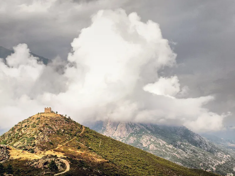
Ruins of Vivario Fort or Pasciola Redoubt
No reviews yet
Have you flown here? Share your experience with other pilots.
+ Write the first reviewHistory
18e siècle La tour retranchée fait partie de la ligne de fortins édifiés lors de l'occupation française afin de compléter le système de défense côtier de la Corse par des postes capables de protéger les communications de l'intérieur de l'île. Projetée par Bourcet de la Saigne, elle fut construite en 1771. Prévue pour une garnison ordinaire de 48 hommes, elle renfermait tous les établissements nécessaires à la troupe. Sous l'Empire, le général Morand, chargé par Napoléon Ier de l'administration de la Corse, transforma cette tour en prison, destinée à recevoir les rebelles à l'autorité impériale.££C'est une redoute en grosse maçonnerie de moëllons, de forme rectangulaire, à trois étages. Les structures du troisième étage peuvent avoir reçu des canons. Un fossé entoure l'ensemble, protégé aux quatre coins par des escarpes et éperons.
Map and restricted areas
Open in the main mapRestricted zones
| Zone | Category | Limits | Conditions |
|---|---|---|---|
| Zena Med | Zone dangereuse | 5491 m above sea level → 9003 m above sea level | Vols interdits sauf lorsque the official document of the zone l'autorise explicitement ou avec l'accord du gestionnaire de la zone lorsqu'il est désigné par the official document of the zone |
| Zrt Tavaro High | ZRT | FL 175 / FL 185 | SUP AIP 055/26 · Du jeudi 16 avril 2026 au mercredi 12 avril 2028 |
Nearby aerodromes
Open aerodromes within 25 km of the spot, heliports included, with their distance and direction from the spot. Near an aerodrome, drone flying is prohibited or height-limited: check the UAS zones map.
| Aerodrome | Type | Distance | Elevation |
|---|---|---|---|
| Aérodrome de Corte | Aerodrome | 13 km N | 345 m |
| Base ULM d'Aghione Casone | Aerodrome | 23 km SE | 51 m |
| Aérodrome de Ghisonaccia - Alzitone | Aerodrome | 24 km SE | 54 m |
Aviation weather (METAR and TAF)
LFKS – Solenzara (BA 126) Air Base VFR
METAR
METAR LFKS 171330Z AUTO 24016G28KT 210V300 9999 FEW028/// BKN036/// BKN048/// ///TCU 23/12 Q1006
- Wind
- 240°, 30 km/h, gusts 52 km/h
- Visibility
- 10 km or more
- Clouds
- Few (1-2/8) at 2,800 ft (850 m) ; Broken (5-7/8) at 3,600 ft (1100 m) ; Broken (5-7/8) at 4,800 ft (1460 m)
- Temperature
- 23 °C, dew point 12 °C
- QNH
- 1006 hPa
- Flight category
- VFR: ceiling > 3,000 ft and visibility > 5 mi
TAF
TAF AMD LFKS 171311Z 1713/1809 27012KT 9999 SCT030 BKN040 TEMPO 1713/1809 27015G25KT FEW030CB PROB40 TEMPO 1716/1720 27020G40KT
| Period (local time) | Change | Wind | Visibility | Weather | Clouds |
|---|---|---|---|---|---|
| 17/11 14:00 → 18/11 10:00 | Initial conditions | 270°, 22 km/h | 10 km or more | Scattered (3-4/8) at 3,000 ft (910 m) ; Broken (5-7/8) at 4,000 ft (1220 m) | |
| 17/11 14:00 → 18/11 10:00 | Temporarily | 270°, 28 km/h, gusts 46 km/h | Few (1-2/8) at 3,000 ft (910 m) (cumulonimbus) | ||
| 17/11 17:00 → 17/11 21:00 | Temporarily, probability 40% | 270°, 37 km/h, gusts 74 km/h |
Weather and Kp index
Sunrise and sunset
| Day | Dawn | Sunrise | Golden hour | Sunset | Dusk | Day length |
|---|---|---|---|---|---|---|
| Tue 17 Nov | 06:46 | 07:16 | 07:16–07:58 · 16:18–17:01 | 17:01 | 17:31 | 9 h 44 |
| Wed 18 Nov | 06:47 | 07:17 | 07:17–08:00 · 16:17–17:00 | 17:00 | 17:30 | 9 h 42 |
| Thu 19 Nov | 06:48 | 07:19 | 07:19–08:01 · 16:16–16:59 | 16:59 | 17:29 | 9 h 40 |
| Fri 20 Nov | 06:49 | 07:20 | 07:20–08:02 · 16:15–16:58 | 16:58 | 17:29 | 9 h 38 |
| Sat 21 Nov | 06:50 | 07:21 | 07:21–08:04 · 16:15–16:57 | 16:57 | 17:28 | 9 h 36 |
| Sun 22 Nov | 06:52 | 07:22 | 07:22–08:05 · 16:14–16:57 | 16:57 | 17:27 | 9 h 34 |
| Mon 23 Nov | 06:53 | 07:23 | 07:23–08:06 · 16:13–16:56 | 16:56 | 17:27 | 9 h 32 |
Reviews (0)
Log in to review this spot. Log in · Create a free account
No reviews yet. Share yours!