

Former Boscodon Abbey
No reviews yet
Have you flown here? Share your experience with other pilots.
+ Write the first reviewHistory
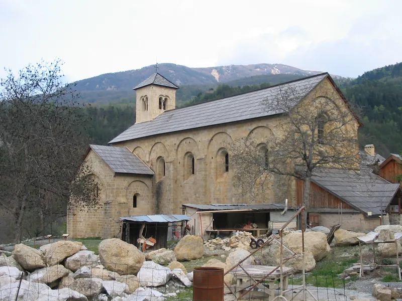
12e siècle ; 17e siècle ; 18e siècle Abbaye fondée au 12e siècle. De cette époque, subsistent : église abbatiale (nef unique de quatre travées, transept, choeur à chevet plat) , aile des convers, une partie du cellier. Du 14e au 16e siècle, destructions provoquées par les troubles dans le sud-est (routiers provençaux) , puis par les guerres de religion. Dès le début du 17e siècle et au 18e siècle, après un incendie en 1692, reconstruction de l'abbaye (bâtiments conventuels, restauration de l'église et du cellier, écurie...). Vendu à des particuliers après la Révolution, l'abbaye est transformée en exploitation agricole.
Map and restricted areas
Open in the main mapRestricted zones
| Zone | Category | Limits | Conditions |
|---|---|---|---|
| GAP | Zone réglementée | 1006 m above ground level → 5040 m above sea level | Vols interdits sauf lorsque the official document of the zone l'autorise explicitement ou avec l'accord du gestionnaire de la zone lorsqu'il est désigné par the official document of the zone |
| GAP | Zone réglementée | 4272 m above sea level → 6259 m above sea level | Vols interdits sauf lorsque the official document of the zone l'autorise explicitement ou avec l'accord du gestionnaire de la zone lorsqu'il est désigné par the official document of the zone |
| Zrt/zdt Riviera | ZRT/ZDT | From about 14,950 m to about 16,750 m above sea level | SUP AIP 233/24 · Du 16 janvier 2025 au 13 janvier 2027 |
Nearby aerodromes
Open aerodromes within 25 km of the spot, heliports included, with their distance and direction from the spot. Near an aerodrome, drone flying is prohibited or height-limited: check the UAS zones map.
| Aerodrome | Type | Distance | Elevation |
|---|---|---|---|
| Barcelonnette - Saint-Pons Airfield | Aerodrome | 18 km SE | 1,132 m |
| Seyne les Alpes Glider Field | Aerodrome | 19 km S | 1,200 m |
| Vars Helistrip | Heliport | 20 km E | 2,163 m |
Aviation weather (METAR and TAF)
No METAR station within 50 km.
Weather and Kp index
Sunrise and sunset
| Day | Dawn | Sunrise | Golden hour | Sunset | Dusk | Day length |
|---|---|---|---|---|---|---|
| Tue 17 Nov | 07:02 | 07:33 | 07:33–08:18 · 16:21–17:05 | 17:05 | 17:37 | 9 h 32 |
| Wed 18 Nov | 07:03 | 07:34 | 07:34–08:19 · 16:20–17:04 | 17:04 | 17:36 | 9 h 29 |
| Thu 19 Nov | 07:04 | 07:36 | 07:36–08:21 · 16:19–17:03 | 17:03 | 17:35 | 9 h 27 |
| Fri 20 Nov | 07:05 | 07:37 | 07:37–08:22 · 16:18–17:03 | 17:03 | 17:34 | 9 h 25 |
| Sat 21 Nov | 07:06 | 07:38 | 07:38–08:23 · 16:17–17:02 | 17:02 | 17:34 | 9 h 23 |
| Sun 22 Nov | 07:08 | 07:40 | 07:40–08:25 · 16:16–17:01 | 17:01 | 17:33 | 9 h 21 |
| Mon 23 Nov | 07:09 | 07:41 | 07:41–08:26 · 16:15–17:00 | 17:00 | 17:32 | 9 h 19 |


Reviews (0)
Log in to review this spot. Log in · Create a free account
No reviews yet. Share yours!