

Roche Castle
No reviews yet
Have you flown here? Share your experience with other pilots.
+ Write the first reviewHistory
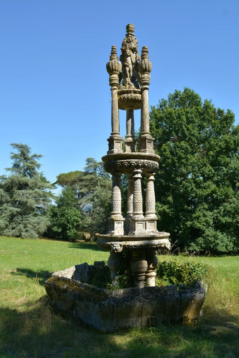
1er quart 17e siècle Les châteaux de Roche à Clairac et de Sauveboeuf à Aubas avaient, entre les deux guerres, le même propriétaire. En vendant celui d'Aubas, il se réserve la fontaine qui est transportée ensuite à Clairac le 12 juin 1927. Un projet de retour à Sauveboeuf était envisagé à la fin des années 1990. La fontaine se compose de trois vasques superposées, diminuant successivement de diamètre et portées par des colonnes. Un motif décoré de figurines, que termine un amortissement prismatique, surmonte la plus élevée. Le fond de la première vasque est orné de quatre têtes de faune en haut relief. Les colonnes du troisième niveau s'épanouissent en volutes pour recevoir les piédouches de quatre pots-à-feu godronnés et surmontés de bobéchons cylindriques. Le motif central du couronnement est figuré par un rocher qui remplit le centre de la vasque et sur lequel deux hommes nus sont adossés à deux sirènes ailées. Au-dessus de leurs têtes s'élève un dé quadrangulaire couronné par un pinacle carré composé de gorges et de moulures superposées, terminées par un fleuron.
Map and restricted areas
Open in the main mapRestricted zones
| Zone | Category | Limits | Conditions |
|---|---|---|---|
| Zrt Victor | ZRT | From the ground up to about 2,000 m above sea level | SUP AIP 219/26 · Du mardi 20 octobre au jeudi 22 octobre 2026 |
| R 46 A | Zone réglementée | 244 m above ground level → 640 m above sea level | Vols interdits sauf lorsque the official document of the zone l'autorise explicitement ou avec l'accord du gestionnaire de la zone lorsqu'il est désigné par the official document of the zone |
| Zena Perigord Low | ZRT | FL 165 / FL 195 | SUP AIP 062/26 · Du jeudi 23 avril 2026 au jeudi 25 mars 2027 |
Nearby aerodromes
Open aerodromes within 25 km of the spot, heliports included, with their distance and direction from the spot. Near an aerodrome, drone flying is prohibited or height-limited: check the UAS zones map.
| Aerodrome | Type | Distance | Elevation |
|---|---|---|---|
| Montpezat d'Agenais | Aerodrome | 11 km E | 37 m |
| Marmande-Virazeil Airport | Aerodrome | 18 km NW | 32 m |
Aviation weather (METAR and TAF)
LFBA – Agen-La Garenne Airport IFR
METAR
METAR LFBA 171400Z AUTO 26004KT 230V290 2900 +RA BR SCT006/// BKN012/// OVC019/// ///TCU 14/14 Q1003 TEMPO 3000 RA BKN014 BKN035 FEW060CB
- Wind
- 260°, 7 km/h
- Visibility
- 2.9 km
- Weather
- Rain heavy ; mist
- Clouds
- Scattered (3-4/8) at 600 ft (180 m) ; Broken (5-7/8) at 1,200 ft (370 m) ; Overcast (8/8) at 1,900 ft (580 m)
- Temperature
- 14 °C, dew point 14 °C
- QNH
- 1003 hPa
- Flight category
- IFR: ceiling 500–1,000 ft or visibility 1–3 mi
TAF
TAF AMD LFBA 171415Z 1714/1721 25010KT CAVOK TEMPO 1714/1717 2000 RA SCT005 BKN014 BKN035 FEW060CB TEMPO 1719/1721 3000 RA BKN040TCU
| Period (local time) | Change | Wind | Visibility | Weather | Clouds |
|---|---|---|---|---|---|
| 17/11 15:00 → 17/11 22:00 | Initial conditions | 250°, 19 km/h | 10 km or more | No significant weather | No significant cloud |
| 17/11 15:00 → 17/11 18:00 | Temporarily | 2.0 km | Rain | Scattered (3-4/8) at 500 ft (150 m) ; Broken (5-7/8) at 1,400 ft (430 m) ; Broken (5-7/8) at 3,500 ft (1070 m) | |
| 17/11 20:00 → 17/11 22:00 | Temporarily | 3.0 km | Rain | Broken (5-7/8) at 4,000 ft (1220 m) (towering cumulus) |
Weather and Kp index
| Day | Weather | Temp. min. / max. | Wind | Rain | Max Kp |
|---|---|---|---|---|---|
| Tue 17 Nov | Rain | 13° / 15° | 19 km/h SW | 7.2 mm | 5 |
| Wed 18 Nov | Clear sky | 12° / 18° | 25 km/h SE | 7.5 mm | 5 |
| Thu 19 Nov | Rain | 10° / 13° | 30 km/h W | 13 mm | 3 |
| Fri 20 Nov | Showers | 10° / 14° | 23 km/h W | 14 mm | 3 |
| Sat 21 Nov | Cloudy | 8° / 15° | 15 km/h E | 3.3 mm | – |
| Sun 22 Nov | Showers | 11° / 15° | 27 km/h W | 3.2 mm | – |
| Mon 23 Nov | Cloudy | 8° / 14° | 12 km/h SW | – | – |
Hour by hour: Tuesday 17 November
| Time | Weather | Temp. | Wind | Rain | Clouds | Kp |
|---|---|---|---|---|---|---|
| 15:00 | Rain | 15° | 14 km/h SW | 0.4 mm | 100 % | 4 |
| 16:00 | Heavy rain | 14° | 13 km/h SW | 4.0 mm | 100 % | 4 |
| 17:00 | Heavy rain | 13° | 10 km/h SW | 1.9 mm | 100 % | 4 |
| 18:00 | Rain | 13° | 12 km/h S | 0.7 mm | 100 % | 4 |
| 19:00 | Cloudy | 13° | 14 km/h SW | – | 93 % | 5 |
| 20:00 | Cloudy | 14° | 18 km/h SW | – | 99 % | 5 |
| 21:00 | Cloudy | 14° | 18 km/h SW | – | 100 % | 5 |
| 22:00 | Cloudy | 14° | 19 km/h SW | – | 100 % | 5 |
Hour by hour: Wednesday 18 November
| Time | Weather | Temp. | Wind | Rain | Clouds | Kp |
|---|---|---|---|---|---|---|
| 06:00 | Clear sky | 14° | 19 km/h W | – | 9 % | 4 |
| 07:00 | Clear sky | 13° | 19 km/h W | – | 5 % | 4 |
| 08:00 | Clear sky | 12° | 18 km/h W | – | 5 % | 4 |
| 09:00 | Fair | 13° | 17 km/h SW | – | 15 % | 4 |
| 10:00 | Clear sky | 15° | 20 km/h W | – | 9 % | 4 |
| 11:00 | Showers | 16° | 20 km/h SW | 0.3 mm | 76 % | 4 |
| 12:00 | Showers | 15° | 21 km/h W | 0.4 mm | 71 % | 4 |
| 13:00 | Clear sky | 15° | 17 km/h W | – | 10 % | 3 |
| 14:00 | Fair | 16° | 19 km/h W | – | 18 % | 3 |
| 15:00 | Fair | 18° | 22 km/h W | – | 15 % | 3 |
| 16:00 | Fair | 17° | 19 km/h W | – | 16 % | 3 |
| 17:00 | Fair | 16° | 13 km/h W | – | 23 % | 3 |
| 18:00 | Cloudy | 13° | 5 km/h S | – | 88 % | 3 |
| 19:00 | Cloudy | 12° | 10 km/h SE | – | 100 % | 2 |
| 20:00 | Cloudy | 14° | 14 km/h SE | – | 100 % | 2 |
| 21:00 | Rain | 14° | 20 km/h SE | 0.4 mm | 100 % | 2 |
| 22:00 | Heavy rain | 14° | 22 km/h SE | 4.0 mm | 100 % | 2 |
Sunrise and sunset
| Day | Dawn | Sunrise | Golden hour | Sunset | Dusk | Day length |
|---|---|---|---|---|---|---|
| Tue 17 Nov | 07:26 | 07:57 | 07:57–08:42 · 16:45–17:30 | 17:30 | 18:01 | 9 h 32 |
| Wed 18 Nov | 07:27 | 07:58 | 07:58–08:43 · 16:44–17:29 | 17:29 | 18:00 | 9 h 30 |
| Thu 19 Nov | 07:28 | 08:00 | 08:00–08:45 · 16:43–17:28 | 17:28 | 18:00 | 9 h 28 |
| Fri 20 Nov | 07:29 | 08:01 | 08:01–08:46 · 16:42–17:27 | 17:27 | 17:59 | 9 h 26 |
| Sat 21 Nov | 07:31 | 08:02 | 08:02–08:47 · 16:41–17:26 | 17:26 | 17:58 | 9 h 24 |
| Sun 22 Nov | 07:32 | 08:04 | 08:04–08:49 · 16:40–17:26 | 17:26 | 17:58 | 9 h 22 |
| Mon 23 Nov | 07:33 | 08:05 | 08:05–08:50 · 16:40–17:25 | 17:25 | 17:57 | 9 h 20 |

Reviews (0)
Log in to review this spot. Log in · Create a free account
No reviews yet. Share yours!