

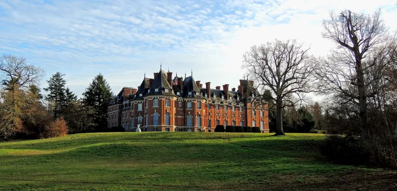
Rivaulde Castle
No reviews yet
Have you flown here? Share your experience with other pilots.
+ Write the first reviewHistory
En 1893, Henri Schneider achète le domaine pour le consacrer à la chasse. L'architecte Paul-Ernest Sanson est engagé pour définir un nouveau château. Le projet retenu en 1898 présente un édifice en L utilisant les fondations anciennes et dont le noeud central du plan est formé par un hall d'entrée avec escalier monumental. L'escalier et le hall distribuent la zone des invités et la salle des chasseurs sur la droite ; les appartements privés sur la gauche. Derrière le vestibule se trouvent trois pièces communes : bibliothèque, salon, salle à manger. La construction du château s'étend de 1900 à 1905. Le château et ses écuries appartiennent à la seconde vague de constructions castrales qui voit le jour à partir de 1890, dans le centre et le sud-est de la Sologne.
Map and restricted areas
Open in the main mapRestricted zones
| Zone | Category | Limits | Conditions |
|---|---|---|---|
| Orleanais | Zone réglementée | 244 m above ground level → 610 m above ground level | Vols interdits sauf lorsque the official document of the zone l'autorise explicitement ou avec l'accord du gestionnaire de la zone lorsqu'il est désigné par the official document of the zone |
| Avord | Zone réglementée | 1372 m above sea level → 2297 m above sea level | Vols interdits sauf lorsque the official document of the zone l'autorise explicitement ou avec l'accord du gestionnaire de la zone lorsqu'il est désigné par the official document of the zone |
| Avord | Zone réglementée | 1529 m above sea level → 3821 m above sea level | Vols interdits sauf lorsque the official document of the zone l'autorise explicitement ou avec l'accord du gestionnaire de la zone lorsqu'il est désigné par the official document of the zone |
Nearby aerodromes
Open aerodromes within 25 km of the spot, heliports included, with their distance and direction from the spot. Near an aerodrome, drone flying is prohibited or height-limited: check the UAS zones map.
| Aerodrome | Type | Distance | Elevation |
|---|---|---|---|
| Aubigny-sur-Nère Airport | Aerodrome | 25 km E | 192 m |
Aviation weather (METAR and TAF)
LFYR – Romorantin Pruniers Airfield VFR
METAR
METAR LFYR 171330Z AUTO 22012KT 170V260 9999 BKN031 BKN038 16/11 Q0996 TEMPO 4000 -RA BECMG 23015G25KT
- Wind
- 220°, 22 km/h
- Visibility
- 10 km or more
- Clouds
- Broken (5-7/8) at 3,100 ft (940 m) ; Broken (5-7/8) at 3,800 ft (1160 m)
- Temperature
- 16 °C, dew point 11 °C
- QNH
- 996 hPa
- Flight category
- VFR: ceiling > 3,000 ft and visibility > 5 mi
TAF
TAF LFYR 170800Z 1709/1809 23015G25KT 9999 BKN020 PROB40 TEMPO 1709/1717 4000 -RA TEMPO 1718/1720 25030G50KT 2000 RA BKN012 BKN020CB PROB40 TEMPO 1803/1809 26025G35KT 4000 SHRA SCT012 BKN020CB
| Period (local time) | Change | Wind | Visibility | Weather | Clouds |
|---|---|---|---|---|---|
| 17/11 10:00 → 18/11 10:00 | Initial conditions | 230°, 28 km/h, gusts 46 km/h | 10 km or more | Broken (5-7/8) at 2,000 ft (610 m) | |
| 17/11 10:00 → 17/11 18:00 | Temporarily, probability 40% | 4.0 km | Rain light | ||
| 17/11 19:00 → 17/11 21:00 | Temporarily | 250°, 56 km/h, gusts 93 km/h | 2.0 km | Rain | Broken (5-7/8) at 1,200 ft (370 m) ; Broken (5-7/8) at 2,000 ft (610 m) (cumulonimbus) |
| 18/11 04:00 → 18/11 10:00 | Temporarily, probability 40% | 260°, 46 km/h, gusts 65 km/h | 4.0 km | Showers of rain | Scattered (3-4/8) at 1,200 ft (370 m) ; Broken (5-7/8) at 2,000 ft (610 m) (cumulonimbus) |
Weather and Kp index
| Day | Weather | Temp. min. / max. | Wind | Rain | Max Kp |
|---|---|---|---|---|---|
| Tue 17 Nov | Cloudy | 12° / 16° | 30 km/h SW | 2.6 mm | 5 |
| Wed 18 Nov | Fair | 10° / 15° | 29 km/h SW | 5.4 mm | 5 |
| Thu 19 Nov | Rain | 9° / 13° | 29 km/h SW | 7.6 mm | 3 |
| Fri 20 Nov | Rain | 9° / 13° | 23 km/h SW | 3.2 mm | 3 |
| Sat 21 Nov | Cloudy | 8° / 12° | 18 km/h SW | 0.1 mm | – |
| Sun 22 Nov | Rain | 8° / 13° | 25 km/h W | 9.3 mm | – |
| Mon 23 Nov | Fair | 6° / 12° | 21 km/h W | 0.5 mm | – |
Hour by hour: Tuesday 17 November
| Time | Weather | Temp. | Wind | Rain | Clouds | Kp |
|---|---|---|---|---|---|---|
| 15:00 | Cloudy | 16° | 27 km/h SW | – | 94 % | 4 |
| 16:00 | Partly cloudy | 16° | 26 km/h SW | – | 52 % | 4 |
| 17:00 | Cloudy | 15° | 28 km/h SW | – | 94 % | 4 |
| 18:00 | Showers | 14° | 27 km/h SW | 0.4 mm | 67 % | 4 |
| 19:00 | Heavy rain | 13° | 30 km/h SW | 1.3 mm | 90 % | 5 |
| 20:00 | Rain | 12° | 29 km/h SW | 0.6 mm | 90 % | 5 |
| 21:00 | Light rain | 12° | 27 km/h SW | 0.3 mm | 100 % | 5 |
| 22:00 | Partly cloudy | 12° | 27 km/h SW | – | 68 % | 5 |
Hour by hour: Wednesday 18 November
| Time | Weather | Temp. | Wind | Rain | Clouds | Kp |
|---|---|---|---|---|---|---|
| 06:00 | Partly cloudy | 11° | 23 km/h SW | – | 67 % | 4 |
| 07:00 | Cloudy | 10° | 22 km/h SW | – | 99 % | 4 |
| 08:00 | Cloudy | 10° | 22 km/h SW | – | 91 % | 4 |
| 09:00 | Partly cloudy | 11° | 22 km/h SW | – | 80 % | 4 |
| 10:00 | Partly cloudy | 12° | 22 km/h SW | – | 64 % | 4 |
| 11:00 | Showers | 13° | 28 km/h SW | 0.2 mm | 44 % | 4 |
| 12:00 | Fair | 14° | 29 km/h SW | – | 24 % | 4 |
| 13:00 | Fair | 14° | 27 km/h SW | – | 23 % | 3 |
| 14:00 | Showers | 15° | 26 km/h SW | 0.1 mm | 17 % | 3 |
| 15:00 | Showers | 15° | 25 km/h SW | 0.1 mm | 21 % | 3 |
| 16:00 | Showers | 13° | 22 km/h SW | 0.2 mm | 33 % | 3 |
| 17:00 | Partly cloudy | 12° | 20 km/h SW | – | 40 % | 3 |
| 18:00 | Partly cloudy | 11° | 19 km/h SW | – | 62 % | 3 |
| 19:00 | Cloudy | 11° | 18 km/h SW | – | 97 % | 2 |
| 20:00 | Cloudy | 11° | 19 km/h SW | – | 100 % | 2 |
| 21:00 | Rain | 12° | 19 km/h S | 0.9 mm | 100 % | 2 |
| 22:00 | Heavy rain | 11° | 21 km/h S | 1.5 mm | 100 % | 2 |
Sunrise and sunset
| Day | Dawn | Sunrise | Golden hour | Sunset | Dusk | Day length |
|---|---|---|---|---|---|---|
| Tue 17 Nov | 07:26 | 07:59 | 07:59–08:47 · 16:26–17:14 | 17:14 | 17:48 | 9 h 14 |
| Wed 18 Nov | 07:27 | 08:01 | 08:01–08:49 · 16:25–17:13 | 17:13 | 17:47 | 9 h 12 |
| Thu 19 Nov | 07:28 | 08:02 | 08:02–08:51 · 16:24–17:12 | 17:12 | 17:46 | 9 h 09 |
| Fri 20 Nov | 07:30 | 08:04 | 08:04–08:52 · 16:22–17:11 | 17:11 | 17:45 | 9 h 07 |
| Sat 21 Nov | 07:31 | 08:05 | 08:05–08:54 · 16:21–17:10 | 17:10 | 17:44 | 9 h 05 |
| Sun 22 Nov | 07:32 | 08:06 | 08:06–08:55 · 16:20–17:09 | 17:09 | 17:43 | 9 h 02 |
| Mon 23 Nov | 07:34 | 08:08 | 08:08–08:57 · 16:19–17:08 | 17:08 | 17:43 | 9 h 00 |

Reviews (0)
Log in to review this spot. Log in · Create a free account
No reviews yet. Share yours!