

The Twin Stones / Ecoivres
2 pilot reviews
“Super spot testé le week end dernier. Idéal pour apprendre, peu d'obstacle autour. Attenti…” — theking62, 4 years ago
Read the reviews + Write my reviewDescription
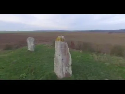
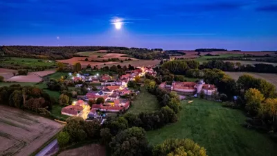
These two menhirs are part of the numerous megalithic sites that are concentrated in certain valleys of the region and which bear witness to rather unknown rites of the second half of the Neolithic period (around 3000 BC). These are two blocks of raw sandstone quarried from nearby wooded hills more than a kilometre away. It is thus several tons of stones that the men had to move in order to erect them on this height which dominates the scarpe. Although these menhirs are often called "Pierres d'Acq" (Stones of Acq) after the name of the neighbouring village, they are located in a place called "Les Droites pierres" (The Straight Stones) on the commune of Mont-Saint-Eloi, near the charming hamlet of Ecoivres.
Map and restricted areas
Open in the main mapNearby aerodromes
Open aerodromes within 25 km of the spot, heliports included, with their distance and direction from the spot. Near an aerodrome, drone flying is prohibited or height-limited: check the UAS zones map.
| Aerodrome | Type | Distance | Elevation | Difference |
|---|---|---|---|---|
| Arras Roclincourt Airfield | Aerodrome | 9.2 km E | 103 m | same altitude as the spot |
| Lens Benifontaine Airfield | Aerodrome | 17 km NE | 51 m | spot 49 m higher |
| Polyclinique Heliport | Heliport | 17 km E | 62 m | spot 38 m higher |
| Vitry en Artois Airfield | Aerodrome | 22 km E | 53 m | spot 47 m higher |
| Polyclinique Du Ternois Heliport | Heliport | 25 km W | 127 m | spot 27 m lower |
Aviation weather (METAR and TAF)
LFQQ – Lille-Lesquin Airport IFR
METAR
METAR LFQQ 210630Z AUTO 19001KT 2900 0800E R26/1400U R08/P5000 BR BCFG NSC M00/M00 Q1018 BECMG CAVOK
- Wind
- 190°, 2 km/h
- Visibility
- 2.9 km
- Weather
- Patches of fog ; mist
- Clouds
- –
- Temperature
- 0 °C, dew point 0 °C
- QNH
- 1018 hPa
- Flight category
- IFR: ceiling 500–1,000 ft or visibility 1–3 mi
TAF
TAF LFQQ 210500Z 2106/2212 VRB04KT CAVOK PROB40 2106/2108 4000 BR BECMG 2108/2110 17005KT PROB40 2117/2120 4000 BR BKN009 PROB30 2120/2124 BKN013 BECMG 2200/2202 09007KT
| Period (local time) | Change | Wind | Visibility | Weather | Clouds |
|---|---|---|---|---|---|
| 21/11 07:00 → 21/11 09:00 | Initial conditions | Variable, 7 km/h | 10 km or more | No significant weather | No significant cloud |
| 21/11 07:00 → 21/11 09:00 | probability 40% | 4.0 km | Mist | ||
| 21/11 09:00 → 22/11 01:00 | Becoming | 170°, 9 km/h | 10 km or more | No significant weather | No significant cloud |
| 21/11 18:00 → 21/11 21:00 | probability 40% | 4.0 km | Mist | Broken (5-7/8) at 900 ft (270 m) | |
| 21/11 21:00 → 22/11 01:00 | probability 30% | Broken (5-7/8) at 1,300 ft (400 m) | |||
| 22/11 01:00 → 22/11 13:00 | Becoming | 090°, 13 km/h | 10 km or more | No significant weather | No significant cloud |
Weather and Kp index
Sunrise and sunset
| Day | Dawn | Sunrise | Golden hour | Sunset | Dusk | Day length |
|---|---|---|---|---|---|---|
| Sat 21 Nov | 07:36 | 08:13 | 08:13–09:06 · 16:04–16:57 | 16:57 | 17:34 | 8 h 44 |
| Sun 22 Nov | 07:38 | 08:14 | 08:14–09:08 · 16:03–16:56 | 16:56 | 17:33 | 8 h 41 |
| Mon 23 Nov | 07:39 | 08:16 | 08:16–09:10 · 16:01–16:55 | 16:55 | 17:32 | 8 h 39 |
| Tue 24 Nov | 07:41 | 08:17 | 08:17–09:12 · 16:00–16:54 | 16:54 | 17:31 | 8 h 36 |
| Wed 25 Nov | 07:42 | 08:19 | 08:19–09:13 · 15:59–16:54 | 16:54 | 17:30 | 8 h 34 |
| Thu 26 Nov | 07:43 | 08:20 | 08:20–09:15 · 15:58–16:53 | 16:53 | 17:30 | 8 h 32 |
| Fri 27 Nov | 07:45 | 08:22 | 08:22–09:17 · 15:57–16:52 | 16:52 | 17:29 | 8 h 30 |

Reviews
Log in to review this spot. Log in · Create a free account
theking62
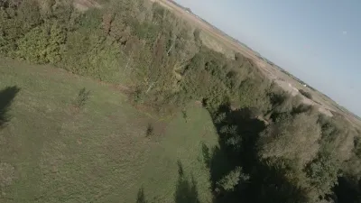
Super spot testé le week end dernier. Idéal pour apprendre, peu d'obstacle autour. Attention toutefois au éventuels promeneurs.
Spar03
J'ai découvert ce lieu un peu par hasard, c'est une bonne surprise et surtout un lieu très facile pour une première fois en drone, ce qui a été mon cas. Le paysage est très bien et le lieu est très facile d'accès.