

Seine-Port (77)
2 pilot reviews
“J'ai signalé plusieurs fois le problème de localisation au site. Je ne peux pas faire garn…” — Evil Dad, 7 years ago
Read the reviews + Write my reviewDescription
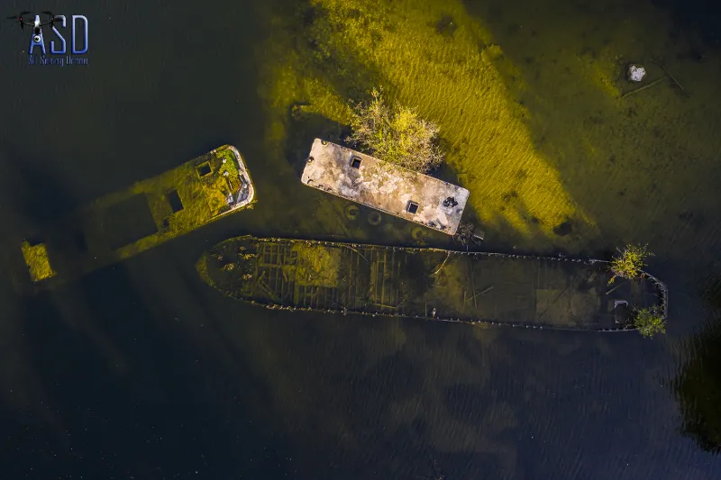
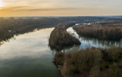
In a pond on the banks of the Seine, a wreck of a barge lies quietly invisible for the quidam who wanders around without knowing the beauty that lies hidden! This wreck can only be seen if you take the time to look for it because the vegetation is dense! However, it can be reached quite easily on foot by following the path between the pond and the Seine. All that remains is to find the place to take off, and that's no easy task! Only a passage between the trees allows you to slip through, but you'll have to be sharp in piloting and avoid an imposing drone!
The Mavic 2 is just perfect but be careful though because in TRIPOD mode, the proximity alarms sound and the drone doesn't want to move! To do this, you will have to switch to sports mode and be meticulous! I also advise you to program the RTH in STATIONARY mode in case you lose the connection because an automatic return is not possible!
Map and restricted areas
Open in the main mapNearby aerodromes
Open aerodromes within 25 km of the spot, heliports included, with their distance and direction from the spot. Near an aerodrome, drone flying is prohibited or height-limited: check the UAS zones map.
| Aerodrome | Type | Distance | Elevation | Difference |
|---|---|---|---|---|
| Centre Hospitalier Heliport | Heliport | 7.4 km NW | 78 m | spot 40 m lower |
| Centre Hospitalier Sud Francilien Heliport | Heliport | 11 km NW | 78 m | spot 40 m lower |
| Melun-Villaroche Air Base | Airport | 12 km NE | 92 m | spot 55 m lower |
| Cerny-La Ferté Alais Airfield | Aerodrome | 16 km W | 138 m | spot 101 m lower |
| Base ULM de Genevrelle à Maisse | Aerodrome | 22 km SW | 128 m | spot 90 m lower |
Aviation weather (METAR and TAF)
LFPM – Melun-Villaroche Air Base IFR
METAR
METAR LFPM 211030Z AUTO 14003KT 100V200 9999 3000 OVC005 09/09 Q1019
- Wind
- 140°, 6 km/h
- Visibility
- 10 km or more
- Clouds
- Overcast (8/8) at 500 ft (150 m)
- Temperature
- 9 °C, dew point 9 °C
- QNH
- 1019 hPa
- Flight category
- IFR: ceiling 500–1,000 ft or visibility 1–3 mi
TAF
Weather and Kp index
Sunrise and sunset
| Day | Dawn | Sunrise | Golden hour | Sunset | Dusk | Day length |
|---|---|---|---|---|---|---|
| Sat 21 Nov | 07:32 | 08:07 | 08:07–08:57 · 16:14–17:05 | 17:05 | 17:39 | 8 h 57 |
| Sun 22 Nov | 07:33 | 08:08 | 08:08–08:59 · 16:13–17:04 | 17:04 | 17:39 | 8 h 55 |
| Mon 23 Nov | 07:35 | 08:10 | 08:10–09:01 · 16:12–17:03 | 17:03 | 17:38 | 8 h 52 |
| Tue 24 Nov | 07:36 | 08:11 | 08:11–09:02 · 16:11–17:02 | 17:02 | 17:37 | 8 h 50 |
| Wed 25 Nov | 07:37 | 08:13 | 08:13–09:04 · 16:10–17:01 | 17:01 | 17:36 | 8 h 48 |
| Thu 26 Nov | 07:39 | 08:14 | 08:14–09:06 · 16:09–17:00 | 17:00 | 17:36 | 8 h 46 |
| Fri 27 Nov | 07:40 | 08:15 | 08:15–09:07 · 16:08–17:00 | 17:00 | 17:35 | 8 h 44 |
Reviews
Log in to review this spot. Log in · Create a free account
Evil Dad
J'ai signalé plusieurs fois le problème de localisation au site. Je ne peux pas faire garnd chose malheureusement. Merci pour le commentaire. Par contre, se déplacer le ong de l'étang est compliqué, il faut être retrait, il y a la fore^t partout.
Eddy
Vol sympa, cet épave provoque à la fois l'angoisse et la curiosité. Le vol peut être facilité par un décollage dans une des nombreuses zones dégagées. Il suffit ensuite de passer par dessus les arbres pour rejoindre le plan d'eau tout en gardant le drone à vue (du moins en hivers) et de se mettre en bordure de l'étang avec sa télécommande. Attention, la localisation de l'épave n'est pas bonne. La loc actuelle désigne une zone asséchée (voir sur google maps) et il faut se décaler d'un étang en aval pour la trouver.... Elle se situe bien en extrémité mais sur un étang plus loin lol. Compter une petite demi-heure de marche pour y accéder depuis le pont de Seine-Port. Mais ça vaut le détour ! Merci à Evil Dad pour ce spot 😊