

BOVES
1 pilot review
“Bonjour, j'ai moi-même voulu effectuer des prises de vues des ruines, mais on est venu me…” — Flopix, 6 years ago
Read the reviews + Write my reviewDescription
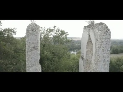
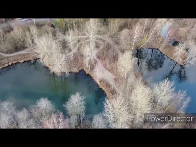
The medieval fortress of Boves is located on the territory of the commune of Boves, 8 km south-east of Amiens, in the Somme. Today, only the castle mound remains, surmounted by two sections of wall about ten metres high, the remains of the south-east tower of the last aristocratic residence built at the end of the 14th century on this entirely man-made mound. The archaeological research carried out continuously from 1996 to the present (2019) is leading to a profound renewal of our knowledge of this site, as well as more generally on the adaptation of the chief town of a major regional centre of power between the ninth and the seventeenth centuries.
Map and restricted areas
Open in the main mapNearby aerodromes
Open aerodromes within 25 km of the spot, heliports included, with their distance and direction from the spot. Near an aerodrome, drone flying is prohibited or height-limited: check the UAS zones map.
| Aerodrome | Type | Distance | Elevation | Difference |
|---|---|---|---|---|
| Aérodrome d'Amiens-Glisy | Airport | 3.3 km N | 63 m | same altitude as the spot |
| Centre Hospitalier Universitaire Nord Heliport | Heliport | 9.3 km NW | 49 m | spot 16 m higher |
| Centre Hospitalier Sud Heliport | Heliport | 9.7 km W | 61 m | spot 5 m higher |
| Montdidier Airfield | Aerodrome | 23 km SE | 109 m | spot 43 m lower |
Aviation weather (METAR and TAF)
LFAQ – Albert-Bray Airport VFR
METAR
METAR LFAQ 211200Z AUTO 14006KT CAVOK 08/05 Q1019 TEMPO 0900 FG VV///
- Wind
- 140°, 11 km/h
- Visibility
- 10 km or more
- Clouds
- –
- Temperature
- 8 °C, dew point 5 °C
- QNH
- 1019 hPa
- Flight category
- VFR: ceiling > 3,000 ft and visibility > 5 mi
TAF
TAF LFAQ 211100Z 2112/2121 12007KT 9999 BKN030 TEMPO 2112/2121 BKN009 PROB40 2112/2121 OVC004 PROB30 2112/2113 0900 FG VV///
| Period (local time) | Change | Wind | Visibility | Weather | Clouds |
|---|---|---|---|---|---|
| 21/11 13:00 → 21/11 22:00 | Initial conditions | 120°, 13 km/h | 10 km or more | Broken (5-7/8) at 3,000 ft (910 m) | |
| 21/11 13:00 → 21/11 22:00 | Temporarily | Broken (5-7/8) at 900 ft (270 m) | |||
| 21/11 13:00 → 21/11 22:00 | probability 40% | Overcast (8/8) at 400 ft (120 m) | |||
| 21/11 13:00 → 21/11 14:00 | probability 30% | 900 m | Fog |
Weather and Kp index
| Day | Weather | Temp. min. / max. | Wind | Rain | Max Kp |
|---|---|---|---|---|---|
| Sat 21 Nov | Cloudy | 6° / 10° | 12 km/h E | – | 2 |
| Sun 22 Nov | Cloudy | 4° / 9° | 18 km/h E | 0.1 mm | 2 |
| Mon 23 Nov | Partly cloudy | -2° / 4° | 15 km/h NE | – | 4 |
| Tue 24 Nov | Clear sky | -3° / 3° | 16 km/h SE | – | 2 |
| Wed 25 Nov | Sleet | -1° / 2° | 16 km/h NE | 1.4 mm | – |
| Thu 26 Nov | Clear sky | -4° / 1° | 14 km/h NE | – | – |
| Fri 27 Nov | Partly cloudy | -4° / 1° | 10 km/h E | – | – |
Hour by hour: Saturday 21 November
| Time | Weather | Temp. | Wind | Rain | Clouds | Kp |
|---|---|---|---|---|---|---|
| 13:00 | Cloudy | 9° | 10 km/h S | – | 89 % | 2 |
| 14:00 | Partly cloudy | 10° | 10 km/h SE | – | 58 % | 2 |
| 15:00 | Partly cloudy | 10° | 10 km/h SE | – | 74 % | 2 |
| 16:00 | Cloudy | 10° | 9 km/h SE | – | 99 % | 2 |
| 17:00 | Cloudy | 9° | 7 km/h SE | – | 100 % | 2 |
| 18:00 | Cloudy | 9° | 10 km/h E | – | 99 % | 2 |
| 19:00 | Cloudy | 8° | 11 km/h SE | – | 100 % | 2 |
| 20:00 | Cloudy | 8° | 10 km/h SE | – | 100 % | 2 |
| 21:00 | Cloudy | 8° | 12 km/h E | – | 97 % | 2 |
| 22:00 | Cloudy | 7° | 11 km/h SE | – | 98 % | 2 |
Hour by hour: Sunday 22 November
| Time | Weather | Temp. | Wind | Rain | Clouds | Kp |
|---|---|---|---|---|---|---|
| 06:00 | Light rain | 6° | 17 km/h E | 0.1 mm | 100 % | 2 |
| 07:00 | Cloudy | 6° | 18 km/h E | – | 100 % | 2 |
| 08:00 | Cloudy | 6° | 17 km/h E | – | 100 % | 2 |
| 09:00 | Cloudy | 6° | 18 km/h E | – | 100 % | 2 |
| 10:00 | Cloudy | 6° | 17 km/h E | – | 100 % | 2 |
| 11:00 | Cloudy | 7° | 15 km/h E | – | 100 % | 2 |
| 12:00 | Cloudy | 8° | 15 km/h E | – | 100 % | 2 |
| 13:00 | Cloudy | 8° | 14 km/h E | – | 100 % | 2 |
| 14:00 | Cloudy | 8° | 14 km/h E | – | 100 % | 2 |
| 15:00 | Cloudy | 9° | 13 km/h E | – | 100 % | 2 |
| 16:00 | Cloudy | 8° | 12 km/h NE | – | 100 % | 2 |
| 17:00 | Cloudy | 7° | 11 km/h NE | – | 100 % | 2 |
| 18:00 | Cloudy | 6° | 12 km/h NE | – | 100 % | 2 |
| 19:00 | Cloudy | 5° | 11 km/h NE | – | 100 % | 2 |
| 20:00 | Cloudy | 5° | 11 km/h NE | – | 100 % | 2 |
| 21:00 | Cloudy | 5° | 13 km/h NE | – | 100 % | 2 |
| 22:00 | Cloudy | 4° | 14 km/h NE | – | 100 % | 2 |
Sunrise and sunset
| Day | Dawn | Sunrise | Golden hour | Sunset | Dusk | Day length |
|---|---|---|---|---|---|---|
| Sat 21 Nov | 07:36 | 08:12 | 08:12–09:05 · 16:08–17:00 | 17:00 | 17:36 | 8 h 48 |
| Sun 22 Nov | 07:38 | 08:14 | 08:14–09:07 · 16:07–16:59 | 16:59 | 17:36 | 8 h 45 |
| Mon 23 Nov | 07:39 | 08:15 | 08:15–09:08 · 16:05–16:59 | 16:59 | 17:35 | 8 h 43 |
| Tue 24 Nov | 07:40 | 08:17 | 08:17–09:10 · 16:04–16:58 | 16:58 | 17:34 | 8 h 40 |
| Wed 25 Nov | 07:42 | 08:18 | 08:18–09:12 · 16:03–16:57 | 16:57 | 17:33 | 8 h 38 |
| Thu 26 Nov | 07:43 | 08:20 | 08:20–09:13 · 16:02–16:56 | 16:56 | 17:32 | 8 h 36 |
| Fri 27 Nov | 07:44 | 08:21 | 08:21–09:15 · 16:01–16:55 | 16:55 | 17:32 | 8 h 34 |

Reviews
Log in to review this spot. Log in · Create a free account
Flopix
Bonjour, j'ai moi-même voulu effectuer des prises de vues des ruines, mais on est venu me dire que je n'avais pas le droit de survoler ce site qui est classé patrimoine archéologique et propriété privée...