

Berg-sur-Moselle
No reviews yet
Have you flown here? Share your experience with other pilots.
+ Write the first reviewDescription
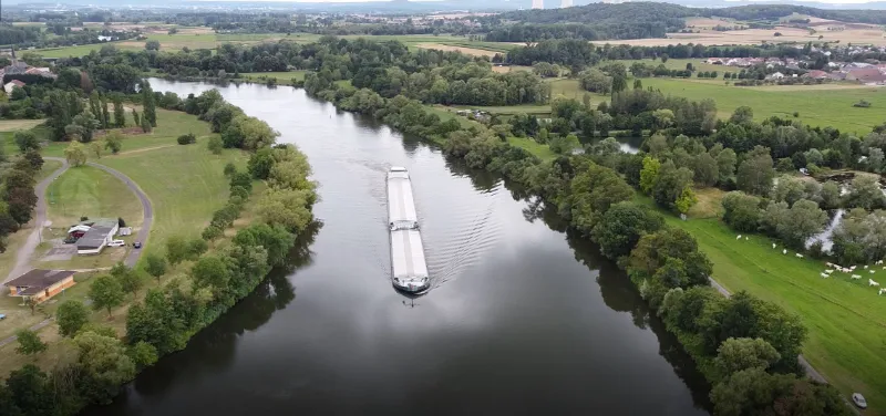
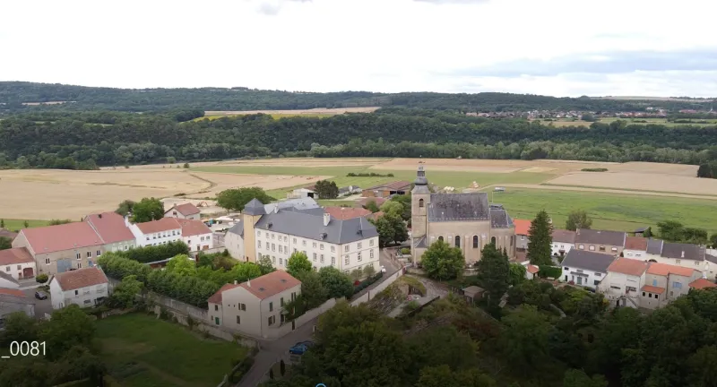
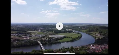
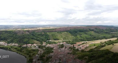
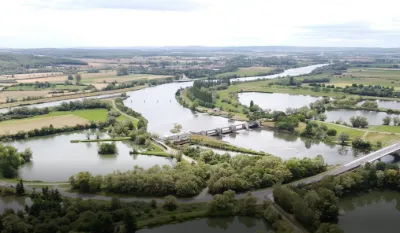
Flying spot located on the left bank of one of the meanders of the Moselle at the foot of the village of Berg-sur-Moselle, and facing the bird island. At the top of the cliff stopping the Moselle to form a loop, you will find the former residence of the abbots of Echternach dating from the 18th century, and the baroque style church dated 1737.
At this point, the Moselle divides into two arms around the bird island, and you can fly with swallows and a couple of kites in summer, swans and other protected species. The barges taking the loop there at their slow pace are a spectacle, without disturbing the fishermen in their boats.
Traditional altitude limit at 150 m. The flying area is free and clear, outside the masks that trees can create. No interference found on the day of the flight. Flying over the village on the cliff and over the campsite located on the right bank, obviously forbidden. And be sure to adopt a sufficient altitude (at least 50 m) so as not to disturb the birds during your flight.
Have a good flight!
Map and restricted areas
Open in the main mapNearby aerodromes
Open aerodromes within 25 km of the spot, heliports included, with their distance and direction from the spot. Near an aerodrome, drone flying is prohibited or height-limited: check the UAS zones map.
| Aerodrome | Type | Distance | Elevation | Difference |
|---|---|---|---|---|
| Luxembourg-Findel International Airport | Major airport | 23 km N | 376 m | spot 227 m lower |
| Clinique Ste-Thérèse heliport | Heliport | 23 km NW | 305 m | spot 156 m lower |
| Hôpital Kirchberg heliport | Heliport | 24 km NW | 372 m | spot 223 m lower |
| Centre Hospitalier Emile Mayrisch Heliport | Heliport | 25 km W | 296 m | spot 147 m lower |
Aviation weather (METAR and TAF)
ELLX – Luxembourg-Findel International Airport VFR
METAR
METAR ELLX 210620Z 00000KT CAVOK 00/M00 Q1018 NOSIG
- Wind
- Calm
- Visibility
- 10 km or more
- Clouds
- –
- Temperature
- 0 °C, dew point 0 °C
- QNH
- 1018 hPa
- Flight category
- VFR: ceiling > 3,000 ft and visibility > 5 mi
TAF
TAF ELLX 210500Z 2106/2212 20005KT 9999 FEW045
| Period (local time) | Change | Wind | Visibility | Weather | Clouds |
|---|---|---|---|---|---|
| 21/11 07:00 → 22/11 13:00 | Initial conditions | 200°, 9 km/h | 10 km or more | Few (1-2/8) at 4,500 ft (1370 m) |
Weather and Kp index
Sunrise and sunset
| Day | Dawn | Sunrise | Golden hour | Sunset | Dusk | Day length |
|---|---|---|---|---|---|---|
| Sat 21 Nov | 07:19 | 07:55 | 07:55–08:47 · 15:54–16:46 | 16:46 | 17:22 | 8 h 51 |
| Sun 22 Nov | 07:21 | 07:56 | 07:56–08:49 · 15:53–16:45 | 16:45 | 17:21 | 8 h 48 |
| Mon 23 Nov | 07:22 | 07:58 | 07:58–08:50 · 15:52–16:44 | 16:44 | 17:20 | 8 h 46 |
| Tue 24 Nov | 07:23 | 07:59 | 07:59–08:52 · 15:51–16:43 | 16:43 | 17:19 | 8 h 44 |
| Wed 25 Nov | 07:25 | 08:01 | 08:01–08:54 · 15:50–16:43 | 16:43 | 17:19 | 8 h 41 |
| Thu 26 Nov | 07:26 | 08:02 | 08:02–08:55 · 15:49–16:42 | 16:42 | 17:18 | 8 h 39 |
| Fri 27 Nov | 07:27 | 08:04 | 08:04–08:57 · 15:48–16:41 | 16:41 | 17:17 | 8 h 37 |

Reviews
Log in to review this spot. Log in · Create a free account
No reviews yet. Share yours!