

Sainte Maime chapelle Sainte Agathe

No reviews yet
Have you flown here? Share your experience with other pilots.
+ Write the first reviewDescription
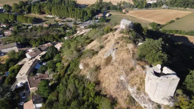
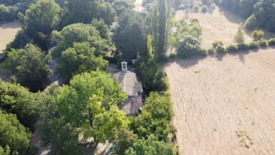
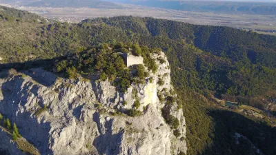
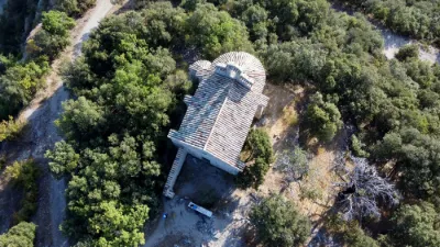
History The Sainte-Agathe chapel and the tower of the count's castle were probably built in the 12th century. Apart from a few remaining sections of wall, they are the only surviving traces of this castle.
In 1220, Raymond Berenger V of Provence, Count of Provence, married Beatrice of Savoy. Some historians believe they lived in this castle with their four daughters: Marguerite, Eleanor, Sanchia and Beatrice, known as "the four Queens." Others think this story is just a legend. In the 14th century, the castle belonged to the lord of Agoult and was part of the viscounty of Reillanne. In the 16th century, it became the property of the Marquisate of Oraison. Since then, it no longer seems to have been inhabited2.
The site offers an excellent panorama over the Mane plain and the confluence of the Laye and the Largue. The chapel and the castle face the village of Dauphin and overlook Saint-Maime1.
The chapel is listed as a historic monument by decree of 4 March 1998, together with the castle1.
Architecture Inside the chapel, you can make out the barely visible 14th-century frescoes of the twelve apostles. On the tower, you can see the stones carefully fitted together by medieval craftsmen. This octagonal tower is the only one of its kind in Provence2.
Map and restricted areas
Open in the main mapNearby aerodromes
Open aerodromes within 25 km of the spot, heliports included, with their distance and direction from the spot. Near an aerodrome, drone flying is prohibited or height-limited: check the UAS zones map.
| Aerodrome | Type | Distance | Elevation | Difference |
|---|---|---|---|---|
| Aérodrome de Vinon | Aerodrome | 19 km S | 275 m | spot 196 m higher |
| Saint Martin de Castillon | Aerodrome | 21 km W | 335 m | spot 136 m higher |
| Altisurface de Banon | Aerodrome | 22 km NW | 1,135 m | spot 664 m lower |
| Aérodrome de Château-Arnoux - Saint-Auban | Aerodrome | 23 km NE | 460 m | spot 11 m higher |
Aviation weather (METAR and TAF)
No METAR station within 50 km.
Weather and Kp index
| Day | Weather | Temp. min. / max. | Wind | Rain | Max Kp |
|---|---|---|---|---|---|
| Sat 21 Nov | Fair | 6° / 15° | 14 km/h SW | 0.2 mm | 2 |
| Sun 22 Nov | Clear sky | 7° / 14° | 27 km/h W | 12 mm | 2 |
| Mon 23 Nov | Cloudy | 5° / 11° | 26 km/h NW | – | 4 |
| Tue 24 Nov | Cloudy | 3° / 12° | 10 km/h W | 0.3 mm | 2 |
| Wed 25 Nov | Rain | 6° / 8° | 10 km/h NE | 22 mm | – |
| Thu 26 Nov | Clear sky | 2° / 10° | 7 km/h NE | 1.1 mm | – |
| Fri 27 Nov | Clear sky | -1° / 10° | 5 km/h N | – | – |
Hour by hour: Saturday 21 November
| Time | Weather | Temp. | Wind | Rain | Clouds | Kp |
|---|---|---|---|---|---|---|
| 12:00 | Fair | 14° | 8 km/h SW | – | 27 % | 2 |
| 13:00 | Fair | 15° | 11 km/h SW | – | 19 % | 1 |
| 14:00 | Fair | 15° | 13 km/h SW | – | 20 % | 1 |
| 15:00 | Partly cloudy | 14° | 14 km/h SW | – | 45 % | 1 |
| 16:00 | Partly cloudy | 13° | 13 km/h SW | – | 47 % | 2 |
| 17:00 | Partly cloudy | 10° | 10 km/h SW | – | 73 % | 2 |
| 18:00 | Partly cloudy | 8° | 8 km/h SW | – | 49 % | 2 |
| 19:00 | Partly cloudy | 7° | 4 km/h N | – | 74 % | 2 |
| 20:00 | Partly cloudy | 6° | 3 km/h N | – | 92 % | 2 |
| 21:00 | Cloudy | 6° | 5 km/h N | – | 91 % | 2 |
| 22:00 | Cloudy | 6° | 6 km/h N | – | 100 % | 2 |
Hour by hour: Sunday 22 November
| Time | Weather | Temp. | Wind | Rain | Clouds | Kp |
|---|---|---|---|---|---|---|
| 06:00 | Heavy rain | 11° | 19 km/h SE | 1.0 mm | 100 % | 2 |
| 07:00 | Heavy rain | 11° | 20 km/h SE | 1.9 mm | 100 % | 2 |
| 08:00 | Heavy rain | 11° | 19 km/h S | 1.6 mm | 100 % | 2 |
| 09:00 | Rain | 10° | 13 km/h SW | 0.5 mm | 100 % | 2 |
| 10:00 | Light rain | 12° | 22 km/h SW | 0.1 mm | 94 % | 2 |
| 11:00 | Showers | 12° | 19 km/h W | 0.2 mm | 76 % | 2 |
| 12:00 | Partly cloudy | 12° | 18 km/h W | – | 63 % | 2 |
| 13:00 | Clear sky | 13° | 22 km/h W | – | 7 % | 2 |
| 14:00 | Clear sky | 14° | 26 km/h W | – | 10 % | 2 |
| 15:00 | Fair | 13° | 27 km/h W | – | 20 % | 2 |
| 16:00 | Clear sky | 12° | 23 km/h W | – | 10 % | 2 |
| 17:00 | Fair | 11° | 25 km/h W | – | 16 % | 2 |
| 18:00 | Fair | 10° | 23 km/h W | – | 17 % | 2 |
| 19:00 | Clear sky | 9° | 19 km/h W | – | 12 % | 2 |
| 20:00 | Fair | 8° | 19 km/h W | – | 36 % | 2 |
| 21:00 | Partly cloudy | 8° | 19 km/h W | – | 44 % | 2 |
| 22:00 | Partly cloudy | 8° | 21 km/h W | – | 77 % | 2 |
Sunrise and sunset
| Day | Dawn | Sunrise | Golden hour | Sunset | Dusk | Day length |
|---|---|---|---|---|---|---|
| Sat 21 Nov | 07:08 | 07:39 | 07:39–08:24 · 16:22–17:06 | 17:06 | 17:38 | 9 h 26 |
| Sun 22 Nov | 07:09 | 07:40 | 07:40–08:25 · 16:21–17:05 | 17:05 | 17:37 | 9 h 24 |
| Mon 23 Nov | 07:10 | 07:42 | 07:42–08:27 · 16:20–17:05 | 17:05 | 17:36 | 9 h 23 |
| Tue 24 Nov | 07:11 | 07:43 | 07:43–08:28 · 16:19–17:04 | 17:04 | 17:36 | 9 h 21 |
| Wed 25 Nov | 07:12 | 07:44 | 07:44–08:29 · 16:18–17:03 | 17:03 | 17:35 | 9 h 19 |
| Thu 26 Nov | 07:13 | 07:45 | 07:45–08:31 · 16:18–17:03 | 17:03 | 17:35 | 9 h 17 |
| Fri 27 Nov | 07:15 | 07:47 | 07:47–08:32 · 16:17–17:02 | 17:02 | 17:34 | 9 h 15 |


Reviews
Log in to review this spot. Log in · Create a free account
No reviews yet. Share yours!