

Grimaud

No reviews yet
Have you flown here? Share your experience with other pilots.
+ Write the first reviewDescription
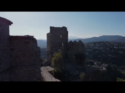
Grimaud Castle is a medieval fortress dating back to at least the 11th century, located in the commune of Grimaud, in the French department of Var. Now in ruins, this monument has been listed as a historic monument by order of 27 December 1996. THE SAINT-ROCH MILL a windmill A windmill has stood on the esplanade since the 16th century. First called the Moulin de la Gardiole, it became the "Saint-Roch" Mill in the 17th century, following the construction of the chapel dedicated to this saint, a few hundred meters away.
It is one of the four windmills in the commune. However, many more mills also produced flour: the water mills. There were 9 of them in the area.
Today, the Pont des Fées is a gem in the middle of the nature of the Massif des Maures. As you look at it, what was its purpose? In the 16th and 17th centuries, it was the aqueduct that supplied the village with water.
Map and restricted areas
Open in the main mapNearby aerodromes
Open aerodromes within 25 km of the spot, heliports included, with their distance and direction from the spot. Near an aerodrome, drone flying is prohibited or height-limited: check the UAS zones map.
| Aerodrome | Type | Distance | Elevation | Difference |
|---|---|---|---|---|
| Sarl R.C.E Heliport | Heliport | 2.6 km E | 6 m | spot 141 m higher |
| Base Hydro-ULM de St Tropez | Seaplane base | 7.1 km E | 0 m | spot 147 m higher |
| La Môle Airport | Aerodrome | 8.4 km S | 18 m | spot 129 m higher |
| Villa Salmanazar Helipad | Heliport | 14 km SE | 101 m | spot 46 m higher |
| Le Luc-Le Cannet Airport | Airport | 16 km NW | 81 m | spot 66 m higher |
Aviation weather (METAR and TAF)
LFMC – Le Luc-Le Cannet Airport VFR
METAR
METAR LFMC 210700Z AUTO 29017KT CAVOK 12/05 Q1017
- Wind
- 290°, 31 km/h
- Visibility
- 10 km or more
- Clouds
- –
- Temperature
- 12 °C, dew point 5 °C
- QNH
- 1017 hPa
- Flight category
- VFR: ceiling > 3,000 ft and visibility > 5 mi
TAF
Weather and Kp index
| Day | Weather | Temp. min. / max. | Wind | Rain | Max Kp |
|---|---|---|---|---|---|
| Sat 21 Nov | Fair | 9° / 18° | 23 km/h W | – | 2 |
| Sun 22 Nov | Partly cloudy | 10° / 16° | 36 km/h W | 9.4 mm | 2 |
| Mon 23 Nov | Fair | 8° / 14° | 41 km/h NW | – | 4 |
| Tue 24 Nov | Cloudy | 5° / 14° | 19 km/h E | 2.8 mm | 2 |
| Wed 25 Nov | Light rain | 9° / 10° | 30 km/h E | 20 mm | – |
| Thu 26 Nov | Cloudy | 8° / 12° | 5 km/h NE | 17 mm | – |
| Fri 27 Nov | Clear sky | 3° / 13° | 7 km/h W | – | – |
Hour by hour: Saturday 21 November
| Time | Weather | Temp. | Wind | Rain | Clouds | Kp |
|---|---|---|---|---|---|---|
| 08:00 | Partly cloudy | 10° | 22 km/h W | – | 86 % | 2 |
| 09:00 | Partly cloudy | 12° | 20 km/h W | – | 98 % | 2 |
| 10:00 | Partly cloudy | 13° | 19 km/h W | – | 97 % | 2 |
| 11:00 | Partly cloudy | 15° | 20 km/h W | – | 85 % | 2 |
| 12:00 | Partly cloudy | 16° | 21 km/h W | – | 53 % | 2 |
| 13:00 | Fair | 17° | 21 km/h W | – | 32 % | 1 |
| 14:00 | Fair | 18° | 22 km/h W | – | 22 % | 1 |
| 15:00 | Fair | 18° | 23 km/h W | – | 30 % | 1 |
| 16:00 | Fair | 16° | 23 km/h W | – | 21 % | 2 |
| 17:00 | Partly cloudy | 14° | 22 km/h W | – | 83 % | 2 |
| 18:00 | Partly cloudy | 12° | 20 km/h W | – | 65 % | 2 |
| 19:00 | Partly cloudy | 10° | 17 km/h W | – | 73 % | 2 |
| 20:00 | Partly cloudy | 9° | 12 km/h W | – | 79 % | 2 |
| 21:00 | Partly cloudy | 9° | 9 km/h W | – | 66 % | 2 |
| 22:00 | Cloudy | 9° | 7 km/h W | – | 100 % | 2 |
Hour by hour: Sunday 22 November
| Time | Weather | Temp. | Wind | Rain | Clouds | Kp |
|---|---|---|---|---|---|---|
| 06:00 | Heavy rain | 11° | 10 km/h NE | 1.5 mm | 100 % | 2 |
| 07:00 | Heavy rain | 11° | 8 km/h E | 1.5 mm | 100 % | 2 |
| 08:00 | Heavy rain | 11° | 14 km/h N | 1.2 mm | 100 % | 2 |
| 09:00 | Heavy rain | 12° | 17 km/h SE | 1.5 mm | 100 % | 2 |
| 10:00 | Rain | 13° | 16 km/h NW | 0.4 mm | 100 % | 2 |
| 11:00 | Partly cloudy | 14° | 18 km/h W | – | 44 % | 2 |
| 12:00 | Partly cloudy | 16° | 29 km/h W | – | 46 % | 2 |
| 13:00 | Partly cloudy | 16° | 33 km/h W | – | 64 % | 2 |
| 14:00 | Clear sky | 16° | 31 km/h W | – | 6 % | 2 |
| 15:00 | Clear sky | 16° | 31 km/h W | – | 2 % | 2 |
| 16:00 | Clear sky | 15° | 30 km/h W | – | 9 % | 2 |
| 17:00 | Clear sky | 14° | 29 km/h W | – | 4 % | 2 |
| 18:00 | Clear sky | 13° | 29 km/h W | – | 6 % | 2 |
| 19:00 | Clear sky | 13° | 30 km/h W | – | 6 % | 2 |
| 20:00 | Clear sky | 12° | 32 km/h W | – | 3 % | 2 |
| 21:00 | Clear sky | 12° | 33 km/h W | – | 12 % | 2 |
| 22:00 | Clear sky | 12° | 34 km/h W | – | 10 % | 2 |
Sunrise and sunset
| Day | Dawn | Sunrise | Golden hour | Sunset | Dusk | Day length |
|---|---|---|---|---|---|---|
| Sat 21 Nov | 07:03 | 07:35 | 07:35–08:18 · 16:21–17:05 | 17:05 | 17:36 | 9 h 30 |
| Sun 22 Nov | 07:05 | 07:36 | 07:36–08:20 · 16:20–17:04 | 17:04 | 17:35 | 9 h 28 |
| Mon 23 Nov | 07:06 | 07:37 | 07:37–08:21 · 16:19–17:04 | 17:04 | 17:35 | 9 h 26 |
| Tue 24 Nov | 07:07 | 07:38 | 07:38–08:23 · 16:19–17:03 | 17:03 | 17:34 | 9 h 24 |
| Wed 25 Nov | 07:08 | 07:39 | 07:39–08:24 · 16:18–17:02 | 17:02 | 17:34 | 9 h 23 |
| Thu 26 Nov | 07:09 | 07:41 | 07:41–08:25 · 16:17–17:02 | 17:02 | 17:33 | 9 h 21 |
| Fri 27 Nov | 07:10 | 07:42 | 07:42–08:26 · 16:17–17:01 | 17:01 | 17:33 | 9 h 19 |




Reviews
Log in to review this spot. Log in · Create a free account
No reviews yet. Share yours!