

The Nivolet Cross

No reviews yet
Have you flown here? Share your experience with other pilots.
+ Write the first reviewDescription
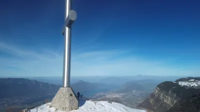
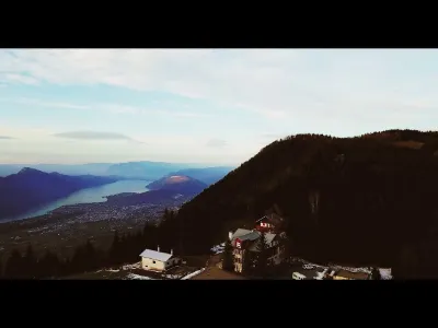
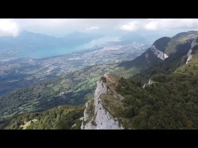
The Nivolet cross is a monumental summit cross installed at the top of the Nivolet (Bauges massif, Prealps, France) and overlooking the city of Chambéry in Savoie. It is located in the municipality of Les Déserts, on the border with Saint-Jean-d'Arvey, at an altitude of 1,547 m.
History On September 15, 1861, the first Nivolet Cross was inaugurated by François-Marie Vibert, Bishop of Maurienne, delegated by Cardinal Billet, who was 78 years old and unable to make the trip himself.
The history of this cross begins when the Chambéry city council decided to cut through the avenue du Comte Vert. To do so, the chapel of the Black Penitents with its calvary and cross had to be demolished.
The prior of the brotherhood, Count Louis de Fernex de Montgex, a retired intendant, gave his agreement on condition that the existing cross be moved to a location visible from the Chambéry valley gap. The location of the Croix des Raforniers on the Dent du Nivolet was chosen for this new monumental cross. On July 31, 1861, Prefect Hippolyte Dieu gave authorization to build the cross. A subscription was opened, of which the count was the main patron. The inhabitants of Les Déserts handled the transport of materials, and Chambéry companies took part in the construction. The cross was to be a metal framework covered with tinplate. On September 15, 1861, the inauguration could take place. In 1867, the arms of the cross were lengthened by one meter. In 1872, the cross's covering was changed. In 1877, the cross was lit up in honor of Pope Pius IX.
On December 22, 1909, a hurricane bent the cross. As the damage was irreparable, another cross had to be built. A committee chaired by the Marquis de la Serraz was formed, with Mr. Abrioud as treasurer. A project was drawn up by Mr. Gotteland, bridge engineer, and Messrs. Dénarié and Bertin, architects. The structure of the cross would be reinforced concrete and its surface covered with aluminum plates. The Grosse company took charge of the construction for the sum of 6,500 francs. The cross is 21.50 m high and sunk 5 m into the ground. Its span is 9.60 m and its circumference 2 m, for a weight of 70 tonnes. The cross, completed in autumn 1910, was inaugurated on Sunday, July 2, 19111 by Vicar General Gavillet in the presence of 3,500 people.
In 1944, the cross was the target of an attack that damaged its base. On July 2, 1960, Mr. Charles Montreuil, president of the committee, inaugurated the illumination of the cross, decided on for the centenary of the annexation of Savoie. As the 1960 installation had been damaged by lightning and vandals, a new installation, financed by EDF, was put in place in 1989 in view of the 1992 Albertville Olympic Games.
For the IGN, this cross is a geodetic site of the French detailed network.
Access The Nivolet cross is accessible on foot only. The most commonly used trail to reach it is the one known as "par les Crêtes", whose starting point is at Le Sire in the La Féclaz ski resort. The total elevation gain does not exceed 140 m since the resort is at roughly the same altitude as the cross, but the walk takes a good hour.
It is also possible to reach it from the Nivolet mountain pasture below, starting from the hamlets of Lovettaz (municipality of Saint-Jean-d'Arvey) or Pragondran (municipality of Verel-Pragondran). An equipped passage (handrails, cables, steps and iron rungs) called "Pas de l'Échelle" allows you to cross a fault in the cliff and reach the final plateau and the cross. A steeper, unequipped variant is possible via the passage known as "la cheminée", located further west. These passages are less frequented than the ridge route because they require more effort as well as a certain amount of caution.
Map and restricted areas
Open in the main mapNearby aerodromes
Open aerodromes within 25 km of the spot, heliports included, with their distance and direction from the spot. Near an aerodrome, drone flying is prohibited or height-limited: check the UAS zones map.
| Aerodrome | Type | Distance | Elevation | Difference |
|---|---|---|---|---|
| Aérodrome de Chambéry Challes-les-Eaux | Aerodrome | 5.9 km S | 297 m | spot 1,229 m higher |
| Centre Hospitalier Heliport | Heliport | 6.9 km SW | 319 m | spot 1,206 m higher |
| Chambéry-Savoie Airport | Airport | 7.2 km W | 237 m | spot 1,288 m higher |
| Hôtel Ariana Heliport | Heliport | 8.0 km NW | 247 m | spot 1,278 m higher |
| La Fullie | Heliport | 13 km E | 1,394 m | spot 131 m higher |
Aviation weather (METAR and TAF)
LFLB – Chambéry-Savoie Airport VFR
METAR
METAR LFLB 210630Z AUTO 22004KT 180V260 9999 FEW048 OVC056 09/08 Q1020 NOSIG
- Wind
- 220°, 7 km/h
- Visibility
- 10 km or more
- Clouds
- Few (1-2/8) at 4,800 ft (1460 m) ; Overcast (8/8) at 5,600 ft (1710 m)
- Temperature
- 9 °C, dew point 8 °C
- QNH
- 1020 hPa
- Flight category
- VFR: ceiling > 3,000 ft and visibility > 5 mi
TAF
TAF LFLB 210200Z 2103/2203 17008KT 9999 BKN050 PROB40 TEMPO 2103/2106 4000 -SHRA SCT040TCU BKN050 TEMPO 2200/2203 4000 RA
| Period (local time) | Change | Wind | Visibility | Weather | Clouds |
|---|---|---|---|---|---|
| 21/11 04:00 → 22/11 04:00 | Initial conditions | 170°, 15 km/h | 10 km or more | Broken (5-7/8) at 5,000 ft (1520 m) | |
| 21/11 04:00 → 21/11 07:00 | Temporarily, probability 40% | 4.0 km | Showers of rain light | Scattered (3-4/8) at 4,000 ft (1220 m) (towering cumulus) ; Broken (5-7/8) at 5,000 ft (1520 m) | |
| 22/11 01:00 → 22/11 04:00 | Temporarily | 4.0 km | Rain |
Weather and Kp index
Sunrise and sunset
| Day | Dawn | Sunrise | Golden hour | Sunset | Dusk | Day length |
|---|---|---|---|---|---|---|
| Sat 21 Nov | 07:11 | 07:44 | 07:44–08:30 · 16:14–17:00 | 17:00 | 17:33 | 9 h 16 |
| Sun 22 Nov | 07:12 | 07:45 | 07:45–08:32 · 16:13–17:00 | 17:00 | 17:32 | 9 h 14 |
| Mon 23 Nov | 07:13 | 07:46 | 07:46–08:33 · 16:12–16:59 | 16:59 | 17:32 | 9 h 12 |
| Tue 24 Nov | 07:15 | 07:48 | 07:48–08:35 · 16:11–16:58 | 16:58 | 17:31 | 9 h 10 |
| Wed 25 Nov | 07:16 | 07:49 | 07:49–08:36 · 16:10–16:57 | 16:57 | 17:30 | 9 h 08 |
| Thu 26 Nov | 07:17 | 07:50 | 07:50–08:37 · 16:09–16:57 | 16:57 | 17:30 | 9 h 06 |
| Fri 27 Nov | 07:18 | 07:51 | 07:51–08:39 · 16:09–16:56 | 16:56 | 17:29 | 9 h 04 |


Reviews
Log in to review this spot. Log in · Create a free account
No reviews yet. Share yours!