

The Abbey of Hautecombe

1 pilot review
“Propriété privée = Décollage et atterrissages sont INTERDITS” — Xtian, 4 years ago
Read the reviews + Write my reviewDescription
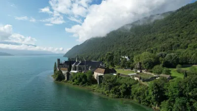
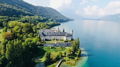
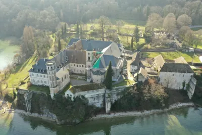
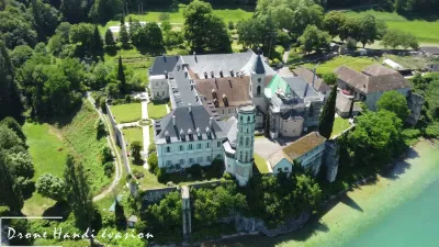
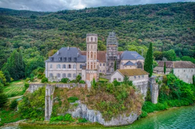
The last king of Italy is buried here The isolation and serenity of a place of prayer that became the necropolis of the princes of Savoy On the winding road from Chambéry, or out on the lake as you approach the abbey, visitors still feel the isolation of this site, chosen by Cistercian monks in the 12th century to found their monastery. A first princess of Savoy was buried in the cloister in 1162. After her, many counts and dukes of Savoy were buried there, as they maintained close ties with the monks of Hautecombe. The abbey became a princely necropolis.
A royal restoration During the French Revolution, the tombs of the princes of Savoy and of noble families were looted and the Gothic decorations destroyed. The abbey, open to the four winds, fell into ruin. It was turned into a faience factory. In 1824, King Charles Felix of Sardinia decided to bring it back to life: he bought the abbey and commissioned its restoration in the style of the day, Troubadour Gothic. The abbey church was covered with sculptures, stucco and painted decoration and once again became the necropolis of the House of Savoy! Upon their deaths, King Charles Felix and his wife Marie-Christine were buried in the church, as were the last king of Italy, Umberto II, in 1983 and his wife Queen Marie-José in 2001.
The Chemin Neuf Community carries on the spiritual vocation of the place After the Cistercian and then Benedictine monks, it is now the Chemin Neuf Community that lives here day to day and carries out missions of hospitality and prayer. It looks after the upkeep and restoration of the monument together with the public authorities, and opens the church to the many visitors to the site.
Find out more and learn about visiting arrangements.
Abbey church of Hautecombe The abbey of Hautecombe in 1674. Borgonio, from the Theatrum Sabaudiae. The abbey in a few dates The influence of Hautecombe Abbey in the history of Savoy and its role as the necropolis of the House of Savoy have made it famous.
12th century Monks from a Haute Combe on the Cessens mountain, northeast of Lac du Bourget, settled on the abbey's present site. Hautecombe Abbey was affiliated with the Cistercian abbey of Clairvaux in 1135. The abbey became Cistercian. The princes of the House of Savoy granted the abbey many privileges and chose it as their burial place.
14th century Count Aymon of Savoy entrusted regional and international artists with the decoration of the church and had the Chapel of the Princes built. The abbey became a princely necropolis.
17th and 18th centuries The convent was restored and enlarged: cloister, dormitory, kitchen, refectory. The roof and stained-glass windows of the church were completely renovated.
French Revolution The royal abbey became "national property". The tombs of the princes of Savoy were looted and the church was turned into a faience factory. The abbey fell into ruin.
1824 King Charles Felix of Sardinia bought the abbey, created the Hautecombe Foundation and had the church renovated in the Neo-Gothic style known as Troubadour by the architect Ernesto Melano. Queen Marie-Christine completed the restoration of the abbey in 1843.
1860 When Savoy was annexed to France, the abbey remained the property of the Hautecombe Foundation and the Royal Apartments remained in the private domain of the House of Savoy.
Today Cistercian and then Benedictine monks were present until 1992. Since then, the Chemin Neuf Community has carried on the abbey's vocation of hospitality and prayer for the Hautecombe Foundation, while overseeing the upkeep and restoration of the monument together with the public authorities. The abbey, listed as a Historic Monument since 1875, is now owned by the Hautecombe Foundation.
Map and restricted areas
Open in the main mapNearby aerodromes
Open aerodromes within 25 km of the spot, heliports included, with their distance and direction from the spot. Near an aerodrome, drone flying is prohibited or height-limited: check the UAS zones map.
| Aerodrome | Type | Distance | Elevation | Difference |
|---|---|---|---|---|
| Lavours | Aerodrome | 6.4 km NW | 234 m | same altitude as the spot |
| Base Hydro-ULM Rhône Lavours | Seaplane base | 7.1 km NW | 239 m | spot 7 m lower |
| Hôtel Ariana Heliport | Heliport | 11 km SE | 247 m | spot 15 m lower |
| Belley - Peyrieu Airfield | Aerodrome | 13 km SW | 225 m | spot 6 m higher |
| Chambéry-Savoie Airport | Airport | 14 km S | 237 m | spot 6 m lower |
Aviation weather (METAR and TAF)
LFLB – Chambéry-Savoie Airport VFR
METAR
METAR LFLB 211100Z AUTO 14003KT 080V200 9999 SCT015 BKN060 12/09 Q1021 NOSIG
- Wind
- 140°, 6 km/h
- Visibility
- 10 km or more
- Clouds
- Scattered (3-4/8) at 1,500 ft (460 m) ; Broken (5-7/8) at 6,000 ft (1830 m)
- Temperature
- 12 °C, dew point 9 °C
- QNH
- 1021 hPa
- Flight category
- VFR: ceiling > 3,000 ft and visibility > 5 mi
TAF
TAF LFLB 210800Z 2109/2209 VRB03KT 9999 SCT050 BECMG 2122/2124 RA BKN050 TEMPO 2203/2209 3000 RA SCT012 BKN020 SCT040TCU BECMG 2205/2207 20010KT
| Period (local time) | Change | Wind | Visibility | Weather | Clouds |
|---|---|---|---|---|---|
| 21/11 10:00 → 21/11 23:00 | Initial conditions | Variable, 6 km/h | 10 km or more | Scattered (3-4/8) at 5,000 ft (1520 m) | |
| 21/11 23:00 → 22/11 06:00 | Becoming | Variable, 6 km/h | 10 km or more | Rain | Broken (5-7/8) at 5,000 ft (1520 m) |
| 22/11 04:00 → 22/11 10:00 | Temporarily | 3.0 km | Rain | Scattered (3-4/8) at 1,200 ft (370 m) ; Broken (5-7/8) at 2,000 ft (610 m) ; Scattered (3-4/8) at 4,000 ft (1220 m) (towering cumulus) | |
| 22/11 06:00 → 22/11 10:00 | Becoming | 200°, 19 km/h | 10 km or more | Rain | Broken (5-7/8) at 5,000 ft (1520 m) |
Weather and Kp index
| Day | Weather | Temp. min. / max. | Wind | Rain | Max Kp |
|---|---|---|---|---|---|
| Sat 21 Nov | Partly cloudy | 8° / 14° | 8 km/h N | – | 2 |
| Sun 22 Nov | Heavy rain | 7° / 10° | 17 km/h S | 38 mm | 2 |
| Mon 23 Nov | Light rain | 7° / 8° | 13 km/h S | 14 mm | 4 |
| Tue 24 Nov | Cloudy | 2° / 7° | 10 km/h NE | 0.2 mm | 2 |
| Wed 25 Nov | Rain | 3° / 4° | 12 km/h NE | 13 mm | – |
| Thu 26 Nov | Cloudy | 2° / 6° | 7 km/h N | 2.3 mm | – |
| Fri 27 Nov | Fair | 1° / 6° | 4 km/h N | – | – |
Hour by hour: Saturday 21 November
| Time | Weather | Temp. | Wind | Rain | Clouds | Kp |
|---|---|---|---|---|---|---|
| 12:00 | Fair | 12° | 3 km/h NE | – | 25 % | 2 |
| 13:00 | Partly cloudy | 13° | 3 km/h N | – | 49 % | 1 |
| 14:00 | Fair | 14° | 5 km/h N | – | 28 % | 1 |
| 15:00 | Partly cloudy | 14° | 8 km/h N | – | 66 % | 1 |
| 16:00 | Partly cloudy | 12° | 6 km/h N | – | 59 % | 2 |
| 17:00 | Partly cloudy | 10° | 5 km/h N | – | 81 % | 2 |
| 18:00 | Partly cloudy | 9° | 4 km/h NE | – | 96 % | 2 |
| 19:00 | Partly cloudy | 9° | 4 km/h NE | – | 88 % | 2 |
| 20:00 | Partly cloudy | 8° | 4 km/h NE | – | 95 % | 2 |
| 21:00 | Partly cloudy | 8° | 4 km/h NE | – | 95 % | 2 |
| 22:00 | Cloudy | 8° | 3 km/h N | – | 95 % | 2 |
Hour by hour: Sunday 22 November
| Time | Weather | Temp. | Wind | Rain | Clouds | Kp |
|---|---|---|---|---|---|---|
| 06:00 | Heavy rain | 8° | 9 km/h NE | 2.5 mm | 100 % | 2 |
| 07:00 | Heavy rain | 8° | 9 km/h NE | 3.1 mm | 100 % | 2 |
| 08:00 | Heavy rain | 8° | 7 km/h N | 2.5 mm | 100 % | 2 |
| 09:00 | Heavy rain | 8° | 6 km/h N | 3.1 mm | 100 % | 2 |
| 10:00 | Heavy rain | 8° | 5 km/h N | 4.1 mm | 100 % | 2 |
| 11:00 | Heavy rain | 8° | 6 km/h S | 1.4 mm | 100 % | 2 |
| 12:00 | Rain | 9° | 9 km/h S | 0.6 mm | 100 % | 2 |
| 13:00 | Heavy rain | 10° | 12 km/h S | 1.8 mm | 99 % | 2 |
| 14:00 | Heavy rain | 10° | 11 km/h S | 1.3 mm | 100 % | 2 |
| 15:00 | Heavy rain | 10° | 14 km/h S | 2.0 mm | 100 % | 2 |
| 16:00 | Light rain | 10° | 17 km/h S | 0.4 mm | 100 % | 2 |
| 17:00 | Showers | 9° | 14 km/h S | 1.0 mm | 85 % | 2 |
| 18:00 | Showers | 8° | 13 km/h S | 0.5 mm | 85 % | 2 |
| 19:00 | Rain | 8° | 12 km/h S | 0.9 mm | 87 % | 2 |
| 20:00 | Heavy rain | 8° | 12 km/h S | 2.0 mm | 100 % | 2 |
| 21:00 | Heavy rain | 8° | 13 km/h S | 1.7 mm | 100 % | 2 |
| 22:00 | Heavy rain | 8° | 15 km/h S | 2.1 mm | 100 % | 2 |
Sunrise and sunset
| Day | Dawn | Sunrise | Golden hour | Sunset | Dusk | Day length |
|---|---|---|---|---|---|---|
| Sat 21 Nov | 07:12 | 07:45 | 07:45–08:31 · 16:14–17:00 | 17:00 | 17:33 | 9 h 15 |
| Sun 22 Nov | 07:13 | 07:46 | 07:46–08:33 · 16:13–17:00 | 17:00 | 17:32 | 9 h 13 |
| Mon 23 Nov | 07:14 | 07:47 | 07:47–08:34 · 16:12–16:59 | 16:59 | 17:32 | 9 h 11 |
| Tue 24 Nov | 07:16 | 07:48 | 07:48–08:36 · 16:11–16:58 | 16:58 | 17:31 | 9 h 09 |
| Wed 25 Nov | 07:17 | 07:50 | 07:50–08:37 · 16:10–16:57 | 16:57 | 17:30 | 9 h 07 |
| Thu 26 Nov | 07:18 | 07:51 | 07:51–08:39 · 16:09–16:57 | 16:57 | 17:30 | 9 h 05 |
| Fri 27 Nov | 07:19 | 07:52 | 07:52–08:40 · 16:08–16:56 | 16:56 | 17:29 | 9 h 03 |
Reviews
Log in to review this spot. Log in · Create a free account
Xtian
Propriété privée = Décollage et atterrissages sont INTERDITS