

Lake Roselend

No reviews yet
Have you flown here? Share your experience with other pilots.
+ Write the first reviewDescription
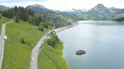
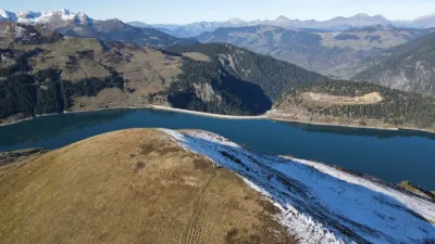
The Roselend dam, together with those of La Gittaz and St Guérin, feeds the La Bâthie power plant. Located in the heart of the high pastures, not far from Mont Blanc, it is a beautiful site for fishing and hiking. It is the 4th highest dam in France. Built between 1955 and 1962, it required 942,368 m3 of concrete, poured at a daily rate of 1,500 to 2,000 m3. It is a buttressed arch-gravity structure (height 150 m, length 804 m). Reservoir surface area: 320 ha. Depth: 130 m. Reservoir volume: 187,000,000 m3. 2,600 workers worked day and night on the site in very harsh conditions. The Chapel of Ste Marie Madeleine was rebuilt on the lakeshore before the dam was filled. The hamlet of Roselend was flooded on 6 May 1960 and 15 of the 54 alpine pastures were submerged. The Route des Grandes Alpes crosses this magnificent alpine pasture area to reach the Tarentaise (outside the snow season - narrow road). This reservoir is a renewable energy reserve equivalent to 500 million Kwh.
Map and restricted areas
Open in the main mapNearby aerodromes
Open aerodromes within 25 km of the spot, heliports included, with their distance and direction from the spot. Near an aerodrome, drone flying is prohibited or height-limited: check the UAS zones map.
| Aerodrome | Type | Distance | Elevation | Difference |
|---|---|---|---|---|
| Altiport de Vaugellaz | Aerodrome | 11 km SE | 2,020 m | spot 473 m lower |
| Megève Altiport | Aerodrome | 16 km N | 1,470 m | spot 77 m higher |
| Crs Alpes Heliport | Heliport | 19 km W | 330 m | spot 1,217 m higher |
| Centre Hospitalier Heliport | Heliport | 19 km W | 335 m | spot 1,212 m higher |
| Mont Blanc Hélicoptères | Heliport | 20 km SE | 2,031 m | spot 484 m lower |
Aviation weather (METAR and TAF)
LFLP – Annecy-Haute-Savoie-Mont Blanc Airport VFR
METAR
METAR LFLP 210630Z AUTO 14005KT 9999 BKN031 BKN052 BKN062 08/07 Q1020 NOSIG
- Wind
- 140°, 9 km/h
- Visibility
- 10 km or more
- Clouds
- Broken (5-7/8) at 3,100 ft (940 m) ; Broken (5-7/8) at 5,200 ft (1580 m) ; Broken (5-7/8) at 6,200 ft (1890 m)
- Temperature
- 8 °C, dew point 7 °C
- QNH
- 1020 hPa
- Flight category
- VFR: ceiling > 3,000 ft and visibility > 5 mi
TAF
TAF LFLP 210200Z 2103/2203 25005KT 9999 BKN040 PROB40 TEMPO 2103/2106 4000 -SHRA SCT025TCU BKN035 TEMPO 2201/2203 4000 RA
| Period (local time) | Change | Wind | Visibility | Weather | Clouds |
|---|---|---|---|---|---|
| 21/11 04:00 → 22/11 04:00 | Initial conditions | 250°, 9 km/h | 10 km or more | Broken (5-7/8) at 4,000 ft (1220 m) | |
| 21/11 04:00 → 21/11 07:00 | Temporarily, probability 40% | 4.0 km | Showers of rain light | Scattered (3-4/8) at 2,500 ft (760 m) (towering cumulus) ; Broken (5-7/8) at 3,500 ft (1070 m) | |
| 22/11 02:00 → 22/11 04:00 | Temporarily | 4.0 km | Rain |
Weather and Kp index
Sunrise and sunset
| Day | Dawn | Sunrise | Golden hour | Sunset | Dusk | Day length |
|---|---|---|---|---|---|---|
| Sat 21 Nov | 07:09 | 07:41 | 07:41–08:28 · 16:11–16:58 | 16:58 | 17:30 | 9 h 16 |
| Sun 22 Nov | 07:10 | 07:43 | 07:43–08:29 · 16:10–16:57 | 16:57 | 17:29 | 9 h 14 |
| Mon 23 Nov | 07:11 | 07:44 | 07:44–08:31 · 16:09–16:56 | 16:56 | 17:29 | 9 h 12 |
| Tue 24 Nov | 07:12 | 07:45 | 07:45–08:32 · 16:08–16:55 | 16:55 | 17:28 | 9 h 10 |
| Wed 25 Nov | 07:13 | 07:46 | 07:46–08:34 · 16:07–16:55 | 16:55 | 17:28 | 9 h 08 |
| Thu 26 Nov | 07:15 | 07:48 | 07:48–08:35 · 16:07–16:54 | 16:54 | 17:27 | 9 h 06 |
| Fri 27 Nov | 07:16 | 07:49 | 07:49–08:37 · 16:06–16:53 | 16:53 | 17:26 | 9 h 04 |


Reviews
Log in to review this spot. Log in · Create a free account
No reviews yet. Share yours!