

Jongieux le Haut

No reviews yet
Have you flown here? Share your experience with other pilots.
+ Write the first reviewDescription
GOOD TO KNOW
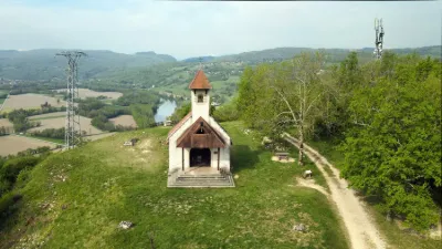
The Chapel is located on the Way of St. James (Chemin de Compostelle) passing through the commune of Jongieux. Set off along this pilgrimage route and discover the landscapes and curiosities of the canton of Yenne.
ABOUT The Chapelle St Romain stands on a hill near a viewpoint overlooking the Rhône plain and the vineyards. A recent building dating from 1995, it was built on the initiative of an association of villagers founded in 1989.
The first stone was blessed by Father Euler and the inauguration took place in 1995 with Bishop Dumoget. It replaces an earlier chapel thought to date from the 6th century, the last traces of which go back to 1930 (cut stones, remains of pointed-arch windows and pillars). Some authors believe that this chapel was in fact the first church of Jongieux, before the church of Jongieux-le-Haut was built in the 17th century. Work was carried out in 1716: rendering, rebuilding of the vault, tiling, plaster. The bell is said to have been bought at that time, but it supposedly flew away on a stormy day and sank into the marshes of Lagneux. This chapel was abandoned during the Revolutionary period.
Before the earlier chapel, there was a Gallo-Roman sanctuary from the 2nd century. It was when a cross was being put in place that people realized the pedestal being used was none other than the slab of a laraire, a small Roman shrine. Following this discovery, excavations were undertaken during the winter of 1938-1939, which uncovered monumental stones and a stele, a white stone from the Rhône quarries at Yenne, dedicated to the Gallic god Silvanus, a god with many functions: god of abundance. This god Silvanus was therefore carved to glorify the vine. The god Silvanus is depicted as follows: " A bearded, long-haired old man with an athletic build, dressed only in a ritual loincloth, holding in his left hand an offering basket filled with fruit and vegetables and carrying, on the right, a bronze cooking pot. On the back, the stele bears the epitaph of a Christian woman with the Germanic name Valho, who died in 504 at the age of 83 and was buried at this spot.
Map and restricted areas
Open in the main mapNearby aerodromes
Open aerodromes within 25 km of the spot, heliports included, with their distance and direction from the spot. Near an aerodrome, drone flying is prohibited or height-limited: check the UAS zones map.
| Aerodrome | Type | Distance | Elevation | Difference |
|---|---|---|---|---|
| Lavours | Aerodrome | 7.4 km N | 234 m | spot 174 m higher |
| Belley - Peyrieu Airfield | Aerodrome | 8.4 km SW | 225 m | spot 183 m higher |
| Base Hydro-ULM Rhône Lavours | Seaplane base | 9.0 km N | 239 m | spot 169 m higher |
| Hôtel Ariana Heliport | Heliport | 11 km SE | 247 m | spot 161 m higher |
| Chambéry-Savoie Airport | Airport | 12 km SE | 237 m | spot 171 m higher |
Aviation weather (METAR and TAF)
LFLB – Chambéry-Savoie Airport VFR
METAR
METAR LFLB 211100Z AUTO 14003KT 080V200 9999 SCT015 BKN060 12/09 Q1021 NOSIG
- Wind
- 140°, 6 km/h
- Visibility
- 10 km or more
- Clouds
- Scattered (3-4/8) at 1,500 ft (460 m) ; Broken (5-7/8) at 6,000 ft (1830 m)
- Temperature
- 12 °C, dew point 9 °C
- QNH
- 1021 hPa
- Flight category
- VFR: ceiling > 3,000 ft and visibility > 5 mi
TAF
TAF LFLB 210800Z 2109/2209 VRB03KT 9999 SCT050 BECMG 2122/2124 RA BKN050 TEMPO 2203/2209 3000 RA SCT012 BKN020 SCT040TCU BECMG 2205/2207 20010KT
| Period (local time) | Change | Wind | Visibility | Weather | Clouds |
|---|---|---|---|---|---|
| 21/11 10:00 → 21/11 23:00 | Initial conditions | Variable, 6 km/h | 10 km or more | Scattered (3-4/8) at 5,000 ft (1520 m) | |
| 21/11 23:00 → 22/11 06:00 | Becoming | Variable, 6 km/h | 10 km or more | Rain | Broken (5-7/8) at 5,000 ft (1520 m) |
| 22/11 04:00 → 22/11 10:00 | Temporarily | 3.0 km | Rain | Scattered (3-4/8) at 1,200 ft (370 m) ; Broken (5-7/8) at 2,000 ft (610 m) ; Scattered (3-4/8) at 4,000 ft (1220 m) (towering cumulus) | |
| 22/11 06:00 → 22/11 10:00 | Becoming | 200°, 19 km/h | 10 km or more | Rain | Broken (5-7/8) at 5,000 ft (1520 m) |
Weather and Kp index
Sunrise and sunset
| Day | Dawn | Sunrise | Golden hour | Sunset | Dusk | Day length |
|---|---|---|---|---|---|---|
| Sat 21 Nov | 07:12 | 07:45 | 07:45–08:31 · 16:14–17:01 | 17:01 | 17:33 | 9 h 16 |
| Sun 22 Nov | 07:13 | 07:46 | 07:46–08:33 · 16:13–17:00 | 17:00 | 17:33 | 9 h 13 |
| Mon 23 Nov | 07:14 | 07:47 | 07:47–08:34 · 16:12–16:59 | 16:59 | 17:32 | 9 h 11 |
| Tue 24 Nov | 07:16 | 07:49 | 07:49–08:36 · 16:11–16:58 | 16:58 | 17:31 | 9 h 09 |
| Wed 25 Nov | 07:17 | 07:50 | 07:50–08:37 · 16:10–16:58 | 16:58 | 17:31 | 9 h 07 |
| Thu 26 Nov | 07:18 | 07:51 | 07:51–08:39 · 16:10–16:57 | 16:57 | 17:30 | 9 h 05 |
| Fri 27 Nov | 07:19 | 07:52 | 07:52–08:40 · 16:09–16:56 | 16:56 | 17:30 | 9 h 04 |

Reviews
Log in to review this spot. Log in · Create a free account
No reviews yet. Share yours!