

Locquirec

No reviews yet
Have you flown here? Share your experience with other pilots.
+ Write the first reviewDescription
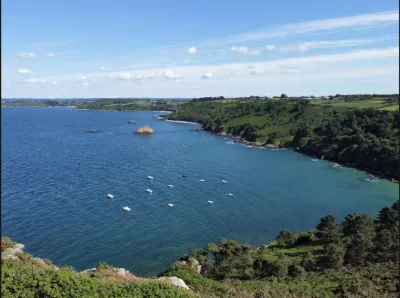
Pors ar Villiec beach is the second beach in the center of Locquirec (200 m away), but it is less in view than the harbor beach because it faces north and is sometimes windier. Partly for this reason, it is a very popular surf spot, even though it is also a favorite with families, as it is larger than the harbor beach and better suited to beach games. After a strong tide or a particular swell, it is often strewn with seaweed, which is cleared fairly quickly since it is close to the center.
To get to this beach from the center of Locquirec, follow the D64 toward the pointes. After the bend, you will find a large free car park on the right near the beach.
Map and restricted areas
Open in the main mapNearby aerodromes
Open aerodromes within 25 km of the spot, heliports included, with their distance and direction from the spot. Near an aerodrome, drone flying is prohibited or height-limited: check the UAS zones map.
| Aerodrome | Type | Distance | Elevation | Difference |
|---|---|---|---|---|
| Centre Hospitalier Heliport | Heliport | 14 km E | 28 m | spot 27 m lower |
| Lannion-Côte de Granit Airport | Airport | 15 km NE | 88 m | spot 87 m lower |
| Morlaix-Ploujean Airport | Airport | 16 km SW | 83 m | spot 82 m lower |
Aviation weather (METAR and TAF)
LFRO – Lannion-Côte de Granit Airport VFR
METAR
METAR LFRO 210700Z AUTO 14007KT CAVOK 05/05 Q1015
- Wind
- 140°, 13 km/h
- Visibility
- 10 km or more
- Clouds
- –
- Temperature
- 5 °C, dew point 5 °C
- QNH
- 1015 hPa
- Flight category
- VFR: ceiling > 3,000 ft and visibility > 5 mi
TAF
Weather and Kp index
| Day | Weather | Temp. min. / max. | Wind | Rain | Max Kp |
|---|---|---|---|---|---|
| Sat 21 Nov | Partly cloudy | 8° / 13° | 33 km/h SE | 2.8 mm | 2 |
| Sun 22 Nov | Cloudy | 10° / 12° | 57 km/h W | 5.9 mm | 2 |
| Mon 23 Nov | Partly cloudy | 10° / 14° | 42 km/h W | 0.3 mm | 4 |
| Tue 24 Nov | Partly cloudy | 6° / 10° | 29 km/h S | – | 2 |
| Wed 25 Nov | Cloudy | 4° / 7° | 18 km/h E | 1.7 mm | – |
| Thu 26 Nov | Fair | 3° / 6° | 15 km/h E | – | – |
| Fri 27 Nov | Cloudy | 3° / 12° | 24 km/h SE | 7.6 mm | – |
Hour by hour: Saturday 21 November
| Time | Weather | Temp. | Wind | Rain | Clouds | Kp |
|---|---|---|---|---|---|---|
| 08:00 | Fog | 8° | 18 km/h S | – | 100 % | 2 |
| 09:00 | Fog | 8° | 18 km/h S | – | 100 % | 2 |
| 10:00 | Fog | 9° | 19 km/h SE | – | 100 % | 2 |
| 11:00 | Fog | 10° | 21 km/h SE | – | 100 % | 2 |
| 12:00 | Cloudy | 11° | 22 km/h SE | – | 93 % | 2 |
| 13:00 | Partly cloudy | 12° | 24 km/h SE | – | 66 % | 1 |
| 14:00 | Cloudy | 13° | 27 km/h SE | – | 90 % | 1 |
| 15:00 | Partly cloudy | 13° | 28 km/h SE | – | 48 % | 1 |
| 16:00 | Fair | 13° | 26 km/h SE | – | 35 % | 2 |
| 17:00 | Partly cloudy | 12° | 27 km/h SE | – | 77 % | 2 |
| 18:00 | Cloudy | 12° | 32 km/h SE | – | 99 % | 2 |
| 19:00 | Cloudy | 12° | 32 km/h SE | – | 100 % | 2 |
| 20:00 | Light rain | 12° | 31 km/h SE | 0.2 mm | 99 % | 2 |
| 21:00 | Heavy rain | 11° | 32 km/h SE | 1.9 mm | 100 % | 2 |
| 22:00 | Rain | 11° | 33 km/h SE | 0.7 mm | 100 % | 2 |
Hour by hour: Sunday 22 November
| Time | Weather | Temp. | Wind | Rain | Clouds | Kp |
|---|---|---|---|---|---|---|
| 06:00 | Cloudy | 12° | 28 km/h SW | – | 93 % | 2 |
| 07:00 | Light rain | 11° | 32 km/h W | 0.3 mm | 100 % | 2 |
| 08:00 | Rain | 11° | 41 km/h W | 0.7 mm | 100 % | 2 |
| 09:00 | Rain | 11° | 52 km/h W | 0.7 mm | 100 % | 2 |
| 10:00 | Rain | 11° | 51 km/h W | 0.5 mm | 100 % | 2 |
| 11:00 | Heavy rain | 11° | 52 km/h W | 1.1 mm | 100 % | 2 |
| 12:00 | Rain | 10° | 53 km/h W | 0.4 mm | 100 % | 2 |
| 13:00 | Cloudy | 11° | 57 km/h W | – | 100 % | 2 |
| 14:00 | Cloudy | 12° | 54 km/h W | – | 100 % | 2 |
| 15:00 | Cloudy | 12° | 55 km/h W | – | 100 % | 2 |
| 16:00 | Cloudy | 12° | 54 km/h W | – | 100 % | 2 |
| 17:00 | Partly cloudy | 12° | 52 km/h W | – | 100 % | 2 |
| 18:00 | Cloudy | 12° | 50 km/h W | – | 100 % | 2 |
| 19:00 | Cloudy | 12° | 49 km/h W | – | 98 % | 2 |
| 20:00 | Partly cloudy | 11° | 48 km/h W | – | 77 % | 2 |
| 21:00 | Fair | 11° | 46 km/h W | – | 35 % | 2 |
| 22:00 | Fair | 11° | 44 km/h W | – | 31 % | 2 |
Sunrise and sunset
| Day | Dawn | Sunrise | Golden hour | Sunset | Dusk | Day length |
|---|---|---|---|---|---|---|
| Sat 21 Nov | 07:57 | 08:32 | 08:32–09:23 · 16:38–17:29 | 17:29 | 18:04 | 8 h 56 |
| Sun 22 Nov | 07:59 | 08:34 | 08:34–09:25 · 16:37–17:28 | 17:28 | 18:03 | 8 h 54 |
| Mon 23 Nov | 08:00 | 08:35 | 08:35–09:26 · 16:36–17:27 | 17:27 | 18:02 | 8 h 51 |
| Tue 24 Nov | 08:01 | 08:37 | 08:37–09:28 · 16:35–17:26 | 17:26 | 18:01 | 8 h 49 |
| Wed 25 Nov | 08:03 | 08:38 | 08:38–09:30 · 16:34–17:25 | 17:25 | 18:01 | 8 h 47 |
| Thu 26 Nov | 08:04 | 08:39 | 08:39–09:31 · 16:33–17:24 | 17:24 | 18:00 | 8 h 45 |
| Fri 27 Nov | 08:05 | 08:41 | 08:41–09:33 · 16:32–17:24 | 17:24 | 17:59 | 8 h 43 |





Reviews
Log in to review this spot. Log in · Create a free account
No reviews yet. Share yours!