

The Montagne de Lure

No reviews yet
Have you flown here? Share your experience with other pilots.
+ Write the first reviewDescription
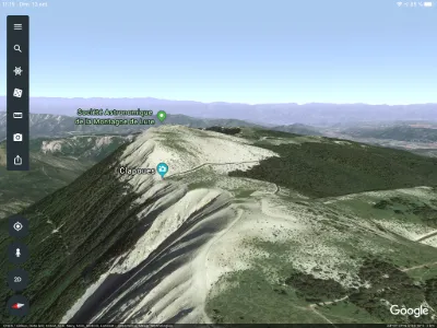
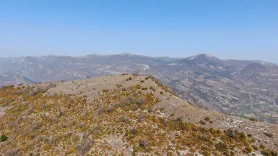
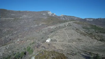
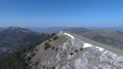
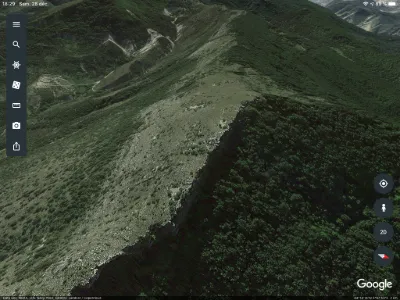
Standing at 1,826 meters above sea level, the Montagne de Lure is the highest peak in the region. A little lower than Mont Ventoux, it shares with it the chalky whiteness of its summit. You might think eternal snow had settled there. Here, in summer as in winter, the slopes are visited by nature lovers. You can go hiking, cycling or cross-country skiing, as well as air sports such as gliding, paragliding and hang gliding.
Located between the Alps and Provence, the Montagne de Lure has a great diversity of landscapes and species from one end of the range to the other. The Pas de la Graille pass lets you link the Jabron Valley to the Pays de Forcalquier via Saint-Étienne-les-Orgues. Let yourself be won over by one of the most beautiful 360° viewpoints:
to the east, the Préalpes de Haute-Provence, the Grandes Alpes to the southeast, the massifs around the Verdon, the Rochers des Mées and the Durance plain to the south, the Luberon ranges to the west, Mont Ventoux to the north, the Préalpes of the Drôme provençale, the Dévoluy, the Vercors and the Écrins. At 1,597 meters above sea level, this road is of course closed during the winter period. In winter, this little paradise is home to the Station de Lure, a family resort for children and beginners. This is where you can discover the oldest ski resort in the Alpes de Haute Provence department: people have been skiing here since 1937…
Map and restricted areas
Open in the main mapNearby aerodromes
Open aerodromes within 25 km of the spot, heliports included, with their distance and direction from the spot. Near an aerodrome, drone flying is prohibited or height-limited: check the UAS zones map.
| Aerodrome | Type | Distance | Elevation | Difference |
|---|---|---|---|---|
| Altisurface de Banon | Aerodrome | 14 km SW | 1,135 m | spot 584 m higher |
| Aérodrome de Château-Arnoux - Saint-Auban | Aerodrome | 17 km SE | 460 m | spot 1,259 m higher |
| Aérodrome de Sistéron-Vaumeilh | Aerodrome | 21 km NE | 540 m | spot 1,179 m higher |
Aviation weather (METAR and TAF)
No METAR station within 50 km.
Weather and Kp index
| Day | Weather | Temp. min. / max. | Wind | Rain | Max Kp |
|---|---|---|---|---|---|
| Sat 21 Nov | Fair | 1° / 9° | 9 km/h N | 0.2 mm | 2 |
| Sun 22 Nov | Fair | 1° / 7° | 26 km/h NW | 25 mm | 2 |
| Mon 23 Nov | Cloudy | -0° / 4° | 26 km/h NW | – | 4 |
| Tue 24 Nov | Cloudy | -2° / 6° | 14 km/h N | 2.5 mm | 2 |
| Wed 25 Nov | Snow | -2° / 2° | 8 km/h E | 31 mm | – |
| Thu 26 Nov | Partly cloudy | -5° / 1° | 4 km/h NW | 0.2 mm | – |
| Fri 27 Nov | Partly cloudy | -7° / 2° | 6 km/h NW | – | – |
Hour by hour: Saturday 21 November
| Time | Weather | Temp. | Wind | Rain | Clouds | Kp |
|---|---|---|---|---|---|---|
| 12:00 | Fair | 7° | 9 km/h N | – | 26 % | 2 |
| 13:00 | Fair | 8° | 7 km/h N | – | 16 % | 1 |
| 14:00 | Fair | 9° | 6 km/h N | – | 20 % | 1 |
| 15:00 | Partly cloudy | 9° | 7 km/h NW | – | 62 % | 1 |
| 16:00 | Partly cloudy | 8° | 8 km/h S | – | 41 % | 2 |
| 17:00 | Partly cloudy | 5° | 5 km/h SW | – | 86 % | 2 |
| 18:00 | Partly cloudy | 3° | 5 km/h W | – | 72 % | 2 |
| 19:00 | Partly cloudy | 2° | 6 km/h W | – | 91 % | 2 |
| 20:00 | Partly cloudy | 1° | 5 km/h SW | – | 94 % | 2 |
| 21:00 | Cloudy | 1° | 4 km/h SE | – | 100 % | 2 |
| 22:00 | Cloudy | 1° | 5 km/h SE | – | 100 % | 2 |
Hour by hour: Sunday 22 November
| Time | Weather | Temp. | Wind | Rain | Clouds | Kp |
|---|---|---|---|---|---|---|
| 06:00 | Heavy rain | 4° | 16 km/h S | 3.5 mm | 100 % | 2 |
| 07:00 | Heavy rain | 4° | 15 km/h S | 4.7 mm | 100 % | 2 |
| 08:00 | Heavy rain | 5° | 18 km/h S | 2.9 mm | 100 % | 2 |
| 09:00 | Heavy rain | 5° | 13 km/h SW | 1.0 mm | 100 % | 2 |
| 10:00 | Light rain | 5° | 15 km/h W | 0.4 mm | 100 % | 2 |
| 11:00 | Showers | 6° | 20 km/h NW | 0.3 mm | 70 % | 2 |
| 12:00 | Partly cloudy | 6° | 19 km/h NW | – | 68 % | 2 |
| 13:00 | Fair | 7° | 21 km/h NW | – | 16 % | 2 |
| 14:00 | Showers | 7° | 24 km/h NW | 0.1 mm | 24 % | 2 |
| 15:00 | Showers | 6° | 26 km/h NW | 0.1 mm | 22 % | 2 |
| 16:00 | Clear sky | 5° | 23 km/h NW | – | 9 % | 2 |
| 17:00 | Fair | 4° | 25 km/h NW | – | 18 % | 2 |
| 18:00 | Showers | 3° | 23 km/h NW | 0.1 mm | 43 % | 2 |
| 19:00 | Fair | 2° | 19 km/h NW | – | 28 % | 2 |
| 20:00 | Sleet | 2° | 19 km/h NW | 0.2 mm | 62 % | 2 |
| 21:00 | Sleet | 2° | 19 km/h NW | 0.1 mm | 63 % | 2 |
| 22:00 | Cloudy | 1° | 18 km/h NW | – | 96 % | 2 |
Sunrise and sunset
| Day | Dawn | Sunrise | Golden hour | Sunset | Dusk | Day length |
|---|---|---|---|---|---|---|
| Sat 21 Nov | 07:08 | 07:40 | 07:40–08:25 · 16:21–17:05 | 17:05 | 17:37 | 9 h 25 |
| Sun 22 Nov | 07:09 | 07:41 | 07:41–08:26 · 16:20–17:05 | 17:05 | 17:36 | 9 h 23 |
| Mon 23 Nov | 07:11 | 07:42 | 07:42–08:27 · 16:19–17:04 | 17:04 | 17:36 | 9 h 21 |
| Tue 24 Nov | 07:12 | 07:44 | 07:44–08:29 · 16:18–17:03 | 17:03 | 17:35 | 9 h 19 |
| Wed 25 Nov | 07:13 | 07:45 | 07:45–08:30 · 16:17–17:03 | 17:03 | 17:35 | 9 h 17 |
| Thu 26 Nov | 07:14 | 07:46 | 07:46–08:32 · 16:17–17:02 | 17:02 | 17:34 | 9 h 16 |
| Fri 27 Nov | 07:15 | 07:47 | 07:47–08:33 · 16:16–17:02 | 17:02 | 17:34 | 9 h 14 |

Reviews
Log in to review this spot. Log in · Create a free account
No reviews yet. Share yours!