

Portbail

No reviews yet
Have you flown here? Share your experience with other pilots.
+ Write the first reviewDescription
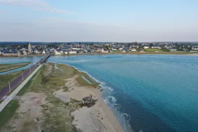
This little haven is a well-known landscape in the Cotentin: crossed from side to side by the bridge of XIII arches, at the foot of the Church of Notre-Dame, it is split in two from north to south. During spring tides, the water rises above the height of the piers and reaches the parapet of the bridge. It is the ideal spot to watch, under the bridge, the strength of the current and its reversal: "la renverse". With each rising tide, the sea works its way inland, where it mixes with the fresh water of the rivers. The haven thus allows an exceptional fauna and flora to develop. At the far end of the Port-Bail estuary, on the road from Omonville to Varreville, there is a tidal gate. Its purpose is to stop sea water from flowing inland and destroying crops because of the salt in the water. It closes automatically with the rising tide and opens at low tide. The Havre de Port-Bail-sur-Mer, a true natural jewel of the Cotentin, offers a constantly changing show as the tides go by. This unique site attracts lovers of authentic landscapes as well as bird-watching enthusiasts: many migratory birds stop over here, taking advantage of the rich mudflats and salt meadows. Depending on the season, it is not unusual to see elegant avocets, egrets, shelducks or even spoonbills, which find a peaceful haven here.
Walks along the haven, on foot or by bike, let you discover a mosaic of preserved natural environments: dunes, marshes, wet meadows and reed beds make up a remarkable ecosystem shaped by water and wind. The emblematic bridge of XIII arches offers a stunning view over the whole site, especially at sunrise or sunset, when the light makes the landscapes even more beautiful.
Port-Bail-sur-Mer is also an ideal starting point for water activities: kayaking, paddleboarding or boat trips let you explore the estuary in a different way, as close to nature as possible. The most curious can also try shore fishing at spring tides, looking for shellfish and crustaceans on the vast expanses uncovered by the sea.
Throughout the year, guided tours and activities are offered to help you better understand how the haven works, its history and its ecological challenges. The Tourist Office is at your disposal to advise you on the best walks and to help you discover all the secrets of this exceptional site.
Map and restricted areas
Open in the main mapNearby aerodromes
Open aerodromes within 25 km of the spot, heliports included, with their distance and direction from the spot. Near an aerodrome, drone flying is prohibited or height-limited: check the UAS zones map.
| Aerodrome | Type | Distance | Elevation | Difference |
|---|---|---|---|---|
| Aérodrome de Lessay | Aerodrome | 20 km SE | 28 m | spot 20 m lower |
Aviation weather (METAR and TAF)
EGJJ – Jersey Airport VFR
METAR
METAR EGJJ 210650Z 18003KT 9999 FEW015 10/09 Q1016
- Wind
- 180°, 6 km/h
- Visibility
- 10 km or more
- Clouds
- Few (1-2/8) at 1,500 ft (460 m)
- Temperature
- 10 °C, dew point 9 °C
- QNH
- 1016 hPa
- Flight category
- VFR: ceiling > 3,000 ft and visibility > 5 mi
TAF
TAF EGJJ 210500Z 2106/2115 22003KT 9999 FEW015 BECMG 2107/2109 14010KT PROB40 TEMPO 2108/2113 1500 BR BKN002 PROB30 TEMPO 2110/2112 0200 FG BKN000
| Period (local time) | Change | Wind | Visibility | Weather | Clouds |
|---|---|---|---|---|---|
| 21/11 07:00 → 21/11 08:00 | Initial conditions | 220°, 6 km/h | 10 km or more | Few (1-2/8) at 1,500 ft (460 m) | |
| 21/11 08:00 → 21/11 16:00 | Becoming | 140°, 19 km/h | 10 km or more | Few (1-2/8) at 1,500 ft (460 m) | |
| 21/11 09:00 → 21/11 14:00 | Temporarily, probability 40% | 1.5 km | Mist | Broken (5-7/8) at 200 ft (60 m) | |
| 21/11 11:00 → 21/11 13:00 | Temporarily, probability 30% | 200 m | Fog | Broken (5-7/8) |
Weather and Kp index
Sunrise and sunset
| Day | Dawn | Sunrise | Golden hour | Sunset | Dusk | Day length |
|---|---|---|---|---|---|---|
| Sat 21 Nov | 07:51 | 08:27 | 08:27–09:18 · 16:27–17:19 | 17:19 | 17:54 | 8 h 51 |
| Sun 22 Nov | 07:53 | 08:28 | 08:28–09:20 · 16:26–17:18 | 17:18 | 17:53 | 8 h 49 |
| Mon 23 Nov | 07:54 | 08:30 | 08:30–09:22 · 16:25–17:17 | 17:17 | 17:52 | 8 h 47 |
| Tue 24 Nov | 07:55 | 08:31 | 08:31–09:24 · 16:23–17:16 | 17:16 | 17:52 | 8 h 44 |
| Wed 25 Nov | 07:57 | 08:33 | 08:33–09:25 · 16:22–17:15 | 17:15 | 17:51 | 8 h 42 |
| Thu 26 Nov | 07:58 | 08:34 | 08:34–09:27 · 16:21–17:14 | 17:14 | 17:50 | 8 h 40 |
| Fri 27 Nov | 07:59 | 08:35 | 08:35–09:29 · 16:20–17:13 | 17:13 | 17:50 | 8 h 38 |



Reviews
Log in to review this spot. Log in · Create a free account
No reviews yet. Share yours!