

Mont Besnéville
No reviews yet
Have you flown here? Share your experience with other pilots.
+ Write the first reviewDescription
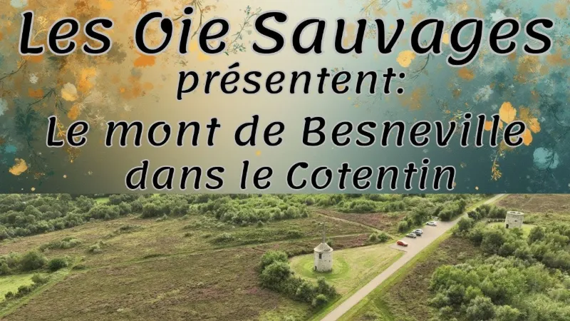
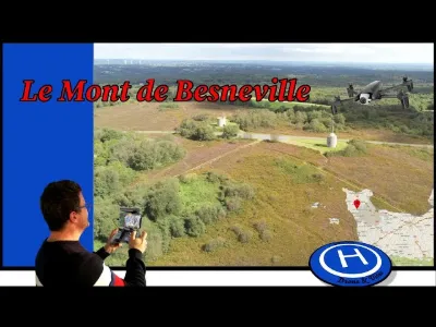
Among heather and gorse, the Mont de Besneville reaches an altitude of 116 m. It offers an exceptional 360° view over the bocage countryside, the coast and the Channel Islands. The hill is topped by three old windmills. One was converted into a chapel after the Second World War, and another has an orientation table offering a unique panorama. Many trails invite you to hike through the heather and moorland. Picnic table, FFRP hiking route, orientation table. The Mont de Besneville is a true haven of nature and tranquility, ideal for fans of outdoor walks, panoramas and rural heritage. Overlooking the Cotentin landscape, it is an emblematic landmark for anyone wanting to escape into the heart of the Norman moorlands. The richness of the site lies as much in its biodiversity as in its history. The marked trails, accessible to hikers of all levels, wind through a mosaic of heather, gorse and grassland, offering a changing palette of colors through the seasons. In spring and summer, the moorland comes alive with birdsong and the blooming of plants typical of acidic environments, while butterflies and insects thrive in this protected environment. The summit of the mount, easily reached on foot, reveals an exceptional panorama over the bocage countryside, the beaches of the Cotentin and, in clear weather, the Channel Islands on the horizon. The orientation table, set up on one of the old windmills, makes it easy to identify the main landmarks of the landscape. It is a perfect spot for photographers, contemplative souls and anyone wanting to take a break in front of the vastness.
Map and restricted areas
Open in the main mapNearby aerodromes
Open aerodromes within 25 km of the spot, heliports included, with their distance and direction from the spot. Near an aerodrome, drone flying is prohibited or height-limited: check the UAS zones map.
| Aerodrome | Type | Distance | Elevation | Difference |
|---|---|---|---|---|
| Aérodrome de Lessay | Aerodrome | 16 km SE | 28 m | spot 18 m lower |
Aviation weather (METAR and TAF)
LFRC – Cherbourg-Maupertus Airport MVFR
METAR
METAR LFRC 210630Z AUTO 18006KT 7000 NSC 05/05 Q1016 TEMPO 0300 FG VV///
- Wind
- 180°, 11 km/h
- Visibility
- 7 km
- Clouds
- –
- Temperature
- 5 °C, dew point 5 °C
- QNH
- 1016 hPa
- Flight category
- MVFR: ceiling 1,000–3,000 ft or visibility 3–5 mi
TAF
TAF LFRC 210500Z 2106/2115 VRB05KT 9999 SCT020 BECMG 2106/2108 15010KT 3000 BR BKN003 PROB40 TEMPO 2106/2110 0300 FG VV/// BECMG 2110/2112 9999 NSW BECMG 2113/2115 BKN006
| Period (local time) | Change | Wind | Visibility | Weather | Clouds |
|---|---|---|---|---|---|
| 21/11 07:00 → 21/11 16:00 | Initial conditions | Variable, 9 km/h | 10 km or more | Scattered (3-4/8) at 2,000 ft (610 m) | |
| 21/11 07:00 → 21/11 11:00 | Becoming | 150°, 19 km/h | 3.0 km | Mist | Broken (5-7/8) at 300 ft (90 m) |
| 21/11 07:00 → 21/11 11:00 | Temporarily, probability 40% | 300 m | Fog | ||
| 21/11 11:00 → 21/11 14:00 | Becoming | 150°, 19 km/h | 10 km or more | No significant weather | Broken (5-7/8) at 300 ft (90 m) |
| 21/11 14:00 → 21/11 16:00 | Becoming | 150°, 19 km/h | 10 km or more | No significant weather | Broken (5-7/8) at 600 ft (180 m) |
Weather and Kp index
Sunrise and sunset
| Day | Dawn | Sunrise | Golden hour | Sunset | Dusk | Day length |
|---|---|---|---|---|---|---|
| Sat 21 Nov | 07:51 | 08:26 | 08:26–09:18 · 16:27–17:18 | 17:18 | 17:54 | 8 h 51 |
| Sun 22 Nov | 07:52 | 08:28 | 08:28–09:20 · 16:25–17:17 | 17:17 | 17:53 | 8 h 49 |
| Mon 23 Nov | 07:53 | 08:29 | 08:29–09:21 · 16:24–17:16 | 17:16 | 17:52 | 8 h 47 |
| Tue 24 Nov | 07:55 | 08:31 | 08:31–09:23 · 16:23–17:15 | 17:15 | 17:51 | 8 h 44 |
| Wed 25 Nov | 07:56 | 08:32 | 08:32–09:25 · 16:22–17:15 | 17:15 | 17:51 | 8 h 42 |
| Thu 26 Nov | 07:57 | 08:34 | 08:34–09:26 · 16:21–17:14 | 17:14 | 17:50 | 8 h 40 |
| Fri 27 Nov | 07:59 | 08:35 | 08:35–09:28 · 16:20–17:13 | 17:13 | 17:49 | 8 h 38 |

Reviews
Log in to review this spot. Log in · Create a free account
No reviews yet. Share yours!