

Bretteville sur Ay

No reviews yet
Have you flown here? Share your experience with other pilots.
+ Write the first reviewDescription
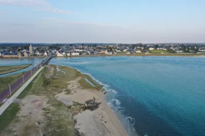
A few kilometers north of Lessay, Bretteville-sur-Ay is a small village of 400 inhabitants facing the English Channel, with an economy centered on oyster farming and market gardening. Even though Betteville sur Ay isn't known as a seaside destination, its population is multiplied by four in the summer season. A destination for green tourism.
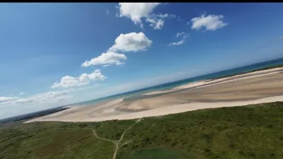
There is a large beach at Bretteville sur Ay with several access points. It is a vast, adjoining sandy beach stretching over several kilometers between the havens of Surville to the north (the neighboring town is Glatigny) and Saint Germain sur Ay to the south. With a very gentle slope, it is safe for children. It is also very popular for shore fishing and sand yachting. A beach appreciated for its calm and unspoiled character.
A few kilometers to the south, Saint Germain sur Ay has a shoreline that continues on from Bretteville. There is a beach supervised in summer. About thirty kilometers away, Agon-Coutainville is one of the main seaside destinations in the area.
Map and restricted areas
Open in the main mapNearby aerodromes
Open aerodromes within 25 km of the spot, heliports included, with their distance and direction from the spot. Near an aerodrome, drone flying is prohibited or height-limited: check the UAS zones map.
| Aerodrome | Type | Distance | Elevation | Difference |
|---|---|---|---|---|
| Aérodrome de Lessay | Aerodrome | 13 km SE | 28 m | spot 20 m lower |
Aviation weather (METAR and TAF)
EGJJ – Jersey Airport VFR
METAR
METAR EGJJ 210650Z 18003KT 9999 FEW015 10/09 Q1016
- Wind
- 180°, 6 km/h
- Visibility
- 10 km or more
- Clouds
- Few (1-2/8) at 1,500 ft (460 m)
- Temperature
- 10 °C, dew point 9 °C
- QNH
- 1016 hPa
- Flight category
- VFR: ceiling > 3,000 ft and visibility > 5 mi
TAF
TAF EGJJ 210500Z 2106/2115 22003KT 9999 FEW015 BECMG 2107/2109 14010KT PROB40 TEMPO 2108/2113 1500 BR BKN002 PROB30 TEMPO 2110/2112 0200 FG BKN000
| Period (local time) | Change | Wind | Visibility | Weather | Clouds |
|---|---|---|---|---|---|
| 21/11 07:00 → 21/11 08:00 | Initial conditions | 220°, 6 km/h | 10 km or more | Few (1-2/8) at 1,500 ft (460 m) | |
| 21/11 08:00 → 21/11 16:00 | Becoming | 140°, 19 km/h | 10 km or more | Few (1-2/8) at 1,500 ft (460 m) | |
| 21/11 09:00 → 21/11 14:00 | Temporarily, probability 40% | 1.5 km | Mist | Broken (5-7/8) at 200 ft (60 m) | |
| 21/11 11:00 → 21/11 13:00 | Temporarily, probability 30% | 200 m | Fog | Broken (5-7/8) |
Weather and Kp index
Sunrise and sunset
| Day | Dawn | Sunrise | Golden hour | Sunset | Dusk | Day length |
|---|---|---|---|---|---|---|
| Sat 21 Nov | 07:51 | 08:26 | 08:26–09:18 · 16:27–17:19 | 17:19 | 17:54 | 8 h 52 |
| Sun 22 Nov | 07:52 | 08:28 | 08:28–09:20 · 16:26–17:18 | 17:18 | 17:53 | 8 h 50 |
| Mon 23 Nov | 07:54 | 08:29 | 08:29–09:21 · 16:25–17:17 | 17:17 | 17:53 | 8 h 47 |
| Tue 24 Nov | 07:55 | 08:31 | 08:31–09:23 · 16:24–17:16 | 17:16 | 17:52 | 8 h 45 |
| Wed 25 Nov | 07:56 | 08:32 | 08:32–09:25 · 16:23–17:15 | 17:15 | 17:51 | 8 h 43 |
| Thu 26 Nov | 07:58 | 08:34 | 08:34–09:26 · 16:22–17:14 | 17:14 | 17:50 | 8 h 40 |
| Fri 27 Nov | 07:59 | 08:35 | 08:35–09:28 · 16:21–17:14 | 17:14 | 17:50 | 8 h 38 |




Reviews
Log in to review this spot. Log in · Create a free account
No reviews yet. Share yours!