

Carteret, old church beach

No reviews yet
Have you flown here? Share your experience with other pilots.
+ Write the first reviewDescription
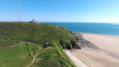
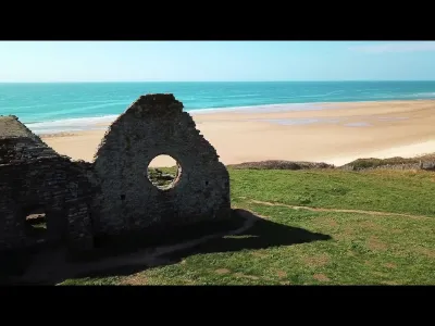
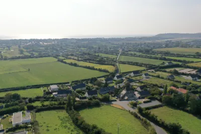
Between Cap de Carteret and the Baubigny dune massif, the old church was built in the 12th century on the cliff. It is dedicated to Saint Germain the Scot, who evangelized the Cotentin in the 5th century. Reworked in the 15th century, the church was already in poor condition when, threatened by the sea, it was abandoned between 1686 and 1689. Partly demolished, its stones were used to enlarge the Saint-Louis church, then the parish church of Carteret. According to local legend, the old church was built near the original village of Carteret, destroyed by the tidal wave of 709 or swallowed up by the sands. The old village keeps all its mystery, as no trace of it has ever been found. At the end of the 19th century, with the fashion for sea bathing, Carteret became a very popular seaside resort. Many visitors walked the customs officers' path and came to admire the ruins of the old church and the panorama it offers.
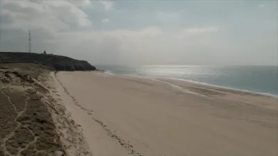
Beach North of Cap de Carteret, wild and immense (it stretches all the way to Pointe du Rozel), it is a prime spot for sand yachting, speed sailing and surfing. You can stroll peacefully through the dunes, which are owned by the Conservatoire du Littoral and are among the largest dunes in Europe!
Because of the dangerous sea currents, swimming is prohibited.
Map and restricted areas
Open in the main mapNearby aerodromes
Open aerodromes within 25 km of the spot, heliports included, with their distance and direction from the spot. Near an aerodrome, drone flying is prohibited or height-limited: check the UAS zones map.
| Aerodrome | Type | Distance | Elevation | Difference |
|---|---|---|---|---|
| Flamanville Heliport | Heliport | 17 km N | 82 m | spot 36 m lower |
Aviation weather (METAR and TAF)
EGJJ – Jersey Airport VFR
METAR
METAR EGJJ 210720Z 17003KT 140V210 9999 FEW012 10/09 Q1016
- Wind
- 170°, 6 km/h
- Visibility
- 10 km or more
- Clouds
- Few (1-2/8) at 1,200 ft (370 m)
- Temperature
- 10 °C, dew point 9 °C
- QNH
- 1016 hPa
- Flight category
- VFR: ceiling > 3,000 ft and visibility > 5 mi
TAF
TAF EGJJ 210500Z 2106/2115 22003KT 9999 FEW015 BECMG 2107/2109 14010KT PROB40 TEMPO 2108/2113 1500 BR BKN002 PROB30 TEMPO 2110/2112 0200 FG BKN000
| Period (local time) | Change | Wind | Visibility | Weather | Clouds |
|---|---|---|---|---|---|
| 21/11 07:00 → 21/11 08:00 | Initial conditions | 220°, 6 km/h | 10 km or more | Few (1-2/8) at 1,500 ft (460 m) | |
| 21/11 08:00 → 21/11 16:00 | Becoming | 140°, 19 km/h | 10 km or more | Few (1-2/8) at 1,500 ft (460 m) | |
| 21/11 09:00 → 21/11 14:00 | Temporarily, probability 40% | 1.5 km | Mist | Broken (5-7/8) at 200 ft (60 m) | |
| 21/11 11:00 → 21/11 13:00 | Temporarily, probability 30% | 200 m | Fog | Broken (5-7/8) |
Weather and Kp index
| Day | Weather | Temp. min. / max. | Wind | Rain | Max Kp |
|---|---|---|---|---|---|
| Sat 21 Nov | Cloudy | 8° / 12° | 31 km/h SE | 0.4 mm | 2 |
| Sun 22 Nov | Heavy rain | 10° / 12° | 65 km/h W | 36 mm | 2 |
| Mon 23 Nov | Light rain | 10° / 12° | 31 km/h NW | 9.0 mm | 4 |
| Tue 24 Nov | Partly cloudy | 5° / 11° | 27 km/h S | – | 2 |
| Wed 25 Nov | Cloudy | 3° / 6° | 34 km/h E | – | – |
| Thu 26 Nov | Partly cloudy | 4° / 6° | 23 km/h E | – | – |
| Fri 27 Nov | Rain | 2° / 11° | 32 km/h SE | 4.0 mm | – |
Hour by hour: Saturday 21 November
| Time | Weather | Temp. | Wind | Rain | Clouds | Kp |
|---|---|---|---|---|---|---|
| 08:00 | Fog | 8° | 13 km/h E | – | 98 % | 2 |
| 09:00 | Fog | 9° | 14 km/h SE | – | 82 % | 2 |
| 10:00 | Fog | 10° | 21 km/h S | – | 89 % | 2 |
| 11:00 | Fog | 10° | 20 km/h SE | – | 87 % | 2 |
| 12:00 | Fog | 10° | 21 km/h SE | – | 100 % | 2 |
| 13:00 | Cloudy | 10° | 22 km/h SE | – | 100 % | 1 |
| 14:00 | Cloudy | 11° | 23 km/h SE | – | 92 % | 1 |
| 15:00 | Partly cloudy | 12° | 23 km/h SE | – | 63 % | 1 |
| 16:00 | Partly cloudy | 12° | 25 km/h SE | – | 43 % | 2 |
| 17:00 | Cloudy | 11° | 27 km/h SE | – | 97 % | 2 |
| 18:00 | Cloudy | 11° | 29 km/h SE | – | 93 % | 2 |
| 19:00 | Cloudy | 10° | 31 km/h SE | – | 100 % | 2 |
| 20:00 | Cloudy | 10° | 31 km/h SE | – | 100 % | 2 |
| 21:00 | Cloudy | 10° | 30 km/h E | – | 100 % | 2 |
| 22:00 | Light rain | 10° | 30 km/h E | 0.1 mm | 100 % | 2 |
Hour by hour: Sunday 22 November
| Time | Weather | Temp. | Wind | Rain | Clouds | Kp |
|---|---|---|---|---|---|---|
| 06:00 | Heavy rain | 10° | 31 km/h E | 1.1 mm | 100 % | 2 |
| 07:00 | Rain | 10° | 29 km/h E | 0.6 mm | 100 % | 2 |
| 08:00 | Rain | 10° | 28 km/h E | 1.0 mm | 100 % | 2 |
| 09:00 | Heavy rain | 10° | 27 km/h E | 3.3 mm | 100 % | 2 |
| 10:00 | Heavy rain | 10° | 29 km/h E | 2.5 mm | 100 % | 2 |
| 11:00 | Heavy rain | 10° | 25 km/h E | 1.5 mm | 100 % | 2 |
| 12:00 | Heavy rain | 10° | 20 km/h E | 2.5 mm | 100 % | 2 |
| 13:00 | Heavy rain | 12° | 42 km/h W | 3.1 mm | 100 % | 2 |
| 14:00 | Heavy rain | 12° | 51 km/h W | 1.8 mm | 100 % | 2 |
| 15:00 | Rain | 12° | 50 km/h W | 0.6 mm | 100 % | 2 |
| 16:00 | Rain | 12° | 57 km/h W | 0.6 mm | 100 % | 2 |
| 17:00 | Rain | 12° | 57 km/h W | 0.6 mm | 100 % | 2 |
| 18:00 | Rain | 12° | 61 km/h W | 0.6 mm | 100 % | 2 |
| 19:00 | Rain | 12° | 65 km/h W | 0.5 mm | 100 % | 2 |
| 20:00 | Heavy rain | 11° | 31 km/h N | 1.1 mm | 100 % | 2 |
| 21:00 | Heavy rain | 11° | 30 km/h N | 1.4 mm | 100 % | 2 |
| 22:00 | Rain | 11° | 22 km/h N | 0.5 mm | 100 % | 2 |
Sunrise and sunset
| Day | Dawn | Sunrise | Golden hour | Sunset | Dusk | Day length |
|---|---|---|---|---|---|---|
| Sat 21 Nov | 07:52 | 08:27 | 08:27–09:19 · 16:27–17:19 | 17:19 | 17:54 | 8 h 51 |
| Sun 22 Nov | 07:53 | 08:29 | 08:29–09:21 · 16:26–17:18 | 17:18 | 17:54 | 8 h 49 |
| Mon 23 Nov | 07:54 | 08:30 | 08:30–09:23 · 16:25–17:17 | 17:17 | 17:53 | 8 h 46 |
| Tue 24 Nov | 07:56 | 08:32 | 08:32–09:24 · 16:24–17:16 | 17:16 | 17:52 | 8 h 44 |
| Wed 25 Nov | 07:57 | 08:33 | 08:33–09:26 · 16:22–17:15 | 17:15 | 17:51 | 8 h 42 |
| Thu 26 Nov | 07:58 | 08:35 | 08:35–09:28 · 16:21–17:14 | 17:14 | 17:51 | 8 h 39 |
| Fri 27 Nov | 08:00 | 08:36 | 08:36–09:29 · 16:20–17:14 | 17:14 | 17:50 | 8 h 37 |

Reviews
Log in to review this spot. Log in · Create a free account
No reviews yet. Share yours!